

Fort Lupin

No reviews yet
Have you flown here? Share your experience with other pilots.
+ Write the first reviewDescription
Fort Lupin.
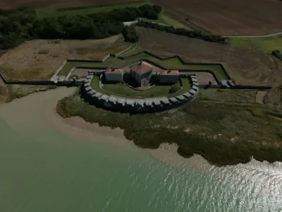
The construction of Fort Lupin was decided in 1683 by Louis XIV to complete the defenses of the Rochefort arsenal. The first plans were drawn by the engineer François Ferry, who submitted them to Vauban. Considering his subordinate's project too costly, Vauban scaled it down and proposed building a smaller fort. Louis XIV accepted this latter project. Work began in 1685 and was completed in 1689, at the start of the War of the League of Augsburg.
Fort Lupin is built on the standard plan established by Vauban for low-battery towers. This horseshoe-shaped battery has 22 gun embrasures. On the land side, the fort is defended by a covered way with two re-entrant places of arms. A bridge crosses the water-filled moat.
At the center, the three-level tower contains: a powder magazine and an arsenal on the ground floor, a chapel on the first floor, and a hoarding at the top. The tower is set diagonally and protected by a dry moat on the battery side. . Two barracks of four rooms each, pierced with arrow slits on the land side, occupy both sides of the tower. A guardhouse, an oven and latrines complete the work.
Although threatened with destruction under the First Empire, Fort Lupin still exists and is very well preserved; the tower's hoarding is the only element that has disappeared.
Decommissioned by the State in 1950, it was sold to private owners and has been listed as a Historic Monument since 1950. It is currently open to visitors on request.
Map and restricted areas
Open in the main mapNearby aerodromes
Open aerodromes within 25 km of the spot, heliports included, with their distance and direction from the spot. Near an aerodrome, drone flying is prohibited or height-limited: check the UAS zones map.
| Aerodrome | Type | Distance | Elevation | Difference |
|---|---|---|---|---|
| Rochefort-Saint-Agnant (BA 721) Airport | Airport | 8.7 km SE | 18 m | spot 16 m lower |
| Aérodrome de Marennes - Le Bournet | Aerodrome | 15 km S | 5 m | same altitude as the spot |
| St Pierre d'Oléron Airfield | Aerodrome | 22 km W | 6 m | same altitude as the spot |
| Centre Hospitalier Heliport | Heliport | 24 km N | 15 m | spot 13 m lower |
Aviation weather (METAR and TAF)
LFBH – La Rochelle-Île de Ré Airport IFR
METAR
METAR LFBH 211130Z AUTO 12012KT 9999 BKN007 13/12 Q1015 BECMG NSC
- Wind
- 120°, 22 km/h
- Visibility
- 10 km or more
- Clouds
- Broken (5-7/8) at 700 ft (210 m)
- Temperature
- 13 °C, dew point 12 °C
- QNH
- 1015 hPa
- Flight category
- IFR: ceiling 500–1,000 ft or visibility 1–3 mi
TAF
TAF LFBH 210500Z 2106/2206 13005KT 3000 BR OVC002 TEMPO 2106/2110 0300 FG VV/// BECMG 2110/2113 CAVOK TEMPO 2116/2119 4000 -RA BECMG 2119/2121 4000 -RA BKN012 TEMPO 2121/2201 2500 DZRA BKN004 OVC012 TEMPO 2201/2203 16020G35KT 2500 RA BKN004 SCT030CB FM220300 25015G25KT 9999 SCT015 TEMPO 2203/2206 25020G40KT 3000 SHRA BKN020CB
| Period (local time) | Change | Wind | Visibility | Weather | Clouds |
|---|---|---|---|---|---|
| 21/11 07:00 → 21/11 11:00 | Initial conditions | 130°, 9 km/h | 3.0 km | Mist | Overcast (8/8) at 200 ft (60 m) |
| 21/11 07:00 → 21/11 11:00 | Temporarily | 300 m | Fog | ||
| 21/11 11:00 → 21/11 20:00 | Becoming | 130°, 9 km/h | 10 km or more | No significant weather | No significant cloud |
| 21/11 17:00 → 21/11 20:00 | Temporarily | 4.0 km | Rain light | ||
| 21/11 20:00 → 22/11 04:00 | Becoming | 130°, 9 km/h | 4.0 km | Rain light | Broken (5-7/8) at 1,200 ft (370 m) |
| 21/11 22:00 → 22/11 02:00 | Temporarily | 2.5 km | Drizzle ; rain | Broken (5-7/8) at 400 ft (120 m) ; Overcast (8/8) at 1,200 ft (370 m) | |
| 22/11 02:00 → 22/11 04:00 | Temporarily | 160°, 37 km/h, gusts 65 km/h | 2.5 km | Rain | Broken (5-7/8) at 400 ft (120 m) ; Scattered (3-4/8) at 3,000 ft (910 m) (cumulonimbus) |
| 22/11 04:00 → 22/11 07:00 | From | 250°, 28 km/h, gusts 46 km/h | 10 km or more | Scattered (3-4/8) at 1,500 ft (460 m) | |
| 22/11 04:00 → 22/11 07:00 | Temporarily | 250°, 37 km/h, gusts 74 km/h | 3.0 km | Showers of rain | Broken (5-7/8) at 2,000 ft (610 m) (cumulonimbus) |
Weather and Kp index
| Day | Weather | Temp. min. / max. | Wind | Rain | Max Kp |
|---|---|---|---|---|---|
| Sat 21 Nov | Cloudy | 12° / 14° | 28 km/h SE | 5.5 mm | 2 |
| Sun 22 Nov | Fair | 12° / 14° | 50 km/h W | 15 mm | 2 |
| Mon 23 Nov | Partly cloudy | 8° / 13° | 31 km/h NW | 0.1 mm | 4 |
| Tue 24 Nov | Cloudy | 7° / 10° | 17 km/h SE | 4.9 mm | 2 |
| Wed 25 Nov | Partly cloudy | 9° / 13° | 19 km/h SE | 2.9 mm | – |
| Thu 26 Nov | Cloudy | 6° / 9° | 12 km/h NE | 0.7 mm | – |
| Fri 27 Nov | Clear sky | 7° / 11° | 18 km/h SE | 0.9 mm | – |
Hour by hour: Saturday 21 November
| Time | Weather | Temp. | Wind | Rain | Clouds | Kp |
|---|---|---|---|---|---|---|
| 12:00 | Cloudy | 13° | 21 km/h SE | – | 100 % | 2 |
| 13:00 | Cloudy | 14° | 21 km/h SE | – | 100 % | 1 |
| 14:00 | Partly cloudy | 14° | 19 km/h SE | – | 100 % | 1 |
| 15:00 | Cloudy | 14° | 21 km/h SE | – | 100 % | 1 |
| 16:00 | Cloudy | 14° | 23 km/h SE | – | 100 % | 2 |
| 17:00 | Rain | 14° | 23 km/h SE | 0.8 mm | 100 % | 2 |
| 18:00 | Heavy rain | 13° | 22 km/h SE | 1.1 mm | 100 % | 2 |
| 19:00 | Heavy rain | 13° | 21 km/h SE | 1.1 mm | 100 % | 2 |
| 20:00 | Rain | 12° | 22 km/h SE | 0.5 mm | 100 % | 2 |
| 21:00 | Rain | 12° | 23 km/h SE | 0.4 mm | 100 % | 2 |
| 22:00 | Rain | 12° | 28 km/h SE | 0.6 mm | 100 % | 2 |
Hour by hour: Sunday 22 November
| Time | Weather | Temp. | Wind | Rain | Clouds | Kp |
|---|---|---|---|---|---|---|
| 06:00 | Light rain | 14° | 42 km/h W | 0.1 mm | 100 % | 2 |
| 07:00 | Showers | 13° | 50 km/h W | 0.3 mm | 73 % | 2 |
| 08:00 | Showers | 12° | 44 km/h W | 0.6 mm | 46 % | 2 |
| 09:00 | Showers | 13° | 40 km/h W | 0.1 mm | 36 % | 2 |
| 10:00 | Showers | 14° | 45 km/h W | 0.4 mm | 52 % | 2 |
| 11:00 | Fair | 13° | 44 km/h W | – | 35 % | 2 |
| 12:00 | Clear sky | 14° | 44 km/h W | – | 7 % | 2 |
| 13:00 | Fair | 14° | 41 km/h W | – | 25 % | 2 |
| 14:00 | Showers | 14° | 48 km/h W | 0.2 mm | 57 % | 2 |
| 15:00 | Partly cloudy | 14° | 49 km/h W | – | 62 % | 2 |
| 16:00 | Fair | 14° | 40 km/h W | – | 27 % | 2 |
| 17:00 | Fair | 13° | 40 km/h W | – | 21 % | 2 |
| 18:00 | Fair | 13° | 36 km/h W | – | 27 % | 2 |
| 19:00 | Fair | 13° | 36 km/h W | – | 34 % | 2 |
| 20:00 | Showers | 13° | 31 km/h W | 0.1 mm | 29 % | 2 |
| 21:00 | Fair | 13° | 33 km/h W | – | 28 % | 2 |
| 22:00 | Clear sky | 13° | 32 km/h W | – | 7 % | 2 |
Sunrise and sunset
| Day | Dawn | Sunrise | Golden hour | Sunset | Dusk | Day length |
|---|---|---|---|---|---|---|
| Sat 21 Nov | 07:40 | 08:13 | 08:13–09:00 · 16:40–17:27 | 17:27 | 18:00 | 9 h 14 |
| Sun 22 Nov | 07:41 | 08:14 | 08:14–09:01 · 16:39–17:26 | 17:26 | 17:59 | 9 h 12 |
| Mon 23 Nov | 07:42 | 08:15 | 08:15–09:03 · 16:38–17:26 | 17:26 | 17:59 | 9 h 10 |
| Tue 24 Nov | 07:44 | 08:17 | 08:17–09:04 · 16:38–17:25 | 17:25 | 17:58 | 9 h 08 |
| Wed 25 Nov | 07:45 | 08:18 | 08:18–09:06 · 16:37–17:24 | 17:24 | 17:57 | 9 h 06 |
| Thu 26 Nov | 07:46 | 08:19 | 08:19–09:07 · 16:36–17:24 | 17:24 | 17:57 | 9 h 04 |
| Fri 27 Nov | 07:47 | 08:20 | 08:20–09:08 · 16:35–17:23 | 17:23 | 17:56 | 9 h 02 |



Reviews
Log in to review this spot. Log in · Create a free account
No reviews yet. Share yours!