

Pont d'Arc Valley



Description
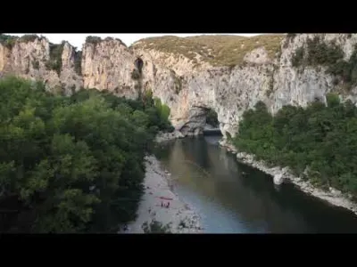
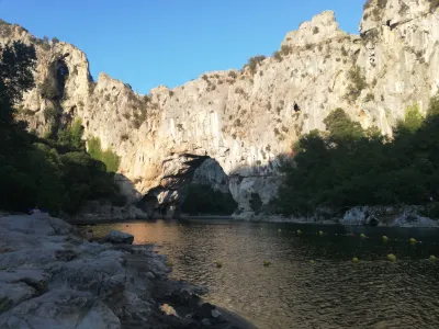
Probably the only place where you can shoot the "Pont d'Arc"! You must not get close to the arch of the Pont (# 150 m) On the other hand, the flight height is barely restricted, so you can go up to 100 m for a beautiful view of the valley. You must keep it in line of sight so you don't hit the cliff face, which rises much higher than the 100 m allowed. The car park is close by; in season you can park early in the morning or late in the day. That's also preferable so you don't fly over the canoes.
Map and restricted areas
Open in the main mapNearby aerodromes
Open aerodromes within 25 km of the spot, heliports included, with their distance and direction from the spot. Near an aerodrome, drone flying is prohibited or height-limited: check the UAS zones map.
| Aerodrome | Type | Distance | Elevation | Difference |
|---|---|---|---|---|
| Ruoms Airport | Aerodrome | 9.3 km NW | 110 m | spot 22 m lower |
| Aubenas-Ardèche Méridional Airport | Airport | 18 km N | 281 m | spot 193 m lower |
| Aérodrome de Pierrelatte | Aerodrome | 25 km E | 60 m | spot 28 m higher |
Aviation weather (METAR and TAF)
LFMO – Orange-Caritat (BA 115) Air Base VFR
METAR
METAR LFMO 211100Z AUTO 25004KT 200V330 CAVOK 13/09 Q1020 NOSIG
- Wind
- 250°, 7 km/h
- Visibility
- 10 km or more
- Clouds
- –
- Temperature
- 13 °C, dew point 9 °C
- QNH
- 1020 hPa
- Flight category
- VFR: ceiling > 3,000 ft and visibility > 5 mi
TAF
TAF LFMO 210800Z 2109/2209 32003KT CAVOK TX16/2115Z TN12/2201Z TEMPO 2121/2209 4000 RA BECMG 2201/2203 13015G25KT
| Period (local time) | Change | Wind | Visibility | Weather | Clouds |
|---|---|---|---|---|---|
| 21/11 10:00 → 22/11 02:00 | Initial conditions | 320°, 6 km/h | 10 km or more | No significant cloud | |
| 21/11 22:00 → 22/11 10:00 | Temporarily | 4.0 km | Rain | ||
| 22/11 02:00 → 22/11 10:00 | Becoming | 130°, 28 km/h, gusts 46 km/h | 10 km or more | No significant cloud |
Weather and Kp index
Sunrise and sunset
| Day | Dawn | Sunrise | Golden hour | Sunset | Dusk | Day length |
|---|---|---|---|---|---|---|
| Sat 21 Nov | 07:14 | 07:46 | 07:46–08:31 · 16:25–17:10 | 17:10 | 17:42 | 9 h 24 |
| Sun 22 Nov | 07:16 | 07:47 | 07:47–08:33 · 16:24–17:10 | 17:10 | 17:41 | 9 h 22 |
| Mon 23 Nov | 07:17 | 07:49 | 07:49–08:34 · 16:23–17:09 | 17:09 | 17:41 | 9 h 20 |
| Tue 24 Nov | 07:18 | 07:50 | 07:50–08:35 · 16:23–17:08 | 17:08 | 17:40 | 9 h 18 |
| Wed 25 Nov | 07:19 | 07:51 | 07:51–08:37 · 16:22–17:08 | 17:08 | 17:40 | 9 h 16 |
| Thu 26 Nov | 07:20 | 07:52 | 07:52–08:38 · 16:21–17:07 | 17:07 | 17:39 | 9 h 14 |
| Fri 27 Nov | 07:21 | 07:54 | 07:54–08:40 · 16:20–17:06 | 17:06 | 17:39 | 9 h 12 |
Reviews
Log in to review this spot. Log in · Create a free account
astrogillou
Belle vidéo, bravo🙂