

Pointe du Grouin Sud, Mont Saint-Michel Bay in the 50

No reviews yet
Have you flown here? Share your experience with other pilots.
+ Write the first reviewDescription
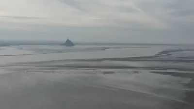
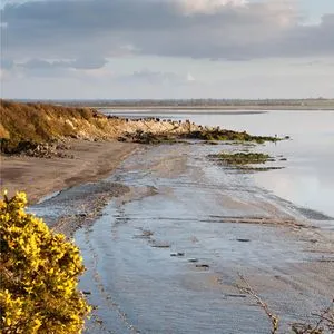
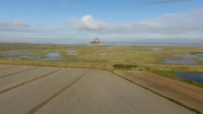
Listed as a UNESCO World Heritage Site, the bay of Mont Saint-Michel is, on its Normandy side, a wild territory made up mainly of the estuaries of two coastal rivers, the Sée and the Sélune. Beyond them, dunes, beaches and back-shore marshes form the transition to the high cliffs of Champeaux that close off the bay to the north. In this environment, the Pointe du Grouin du Sud is a fantastic gateway to understanding this landscape that seems unchanging.
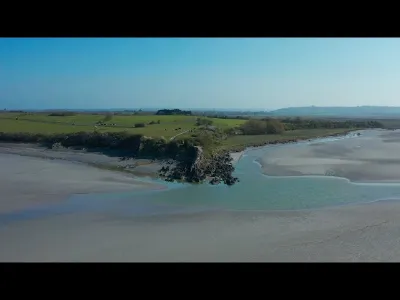
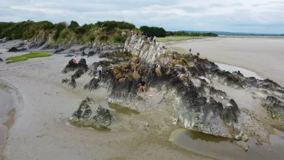
The point is made up of the oldest rocks in the bay. These rocks now form a slender headland that marks the boundary between the estuaries of the Sée and the Sélune and the vast expanses of the sands of the Grande baie. Covered in orange lichens of the genus xanthoria and deeply eaten away by salt, this headland is also a fantastic vantage point for watching the bay's great natural phenomenon, the tidal bore. An exceptional expression of the strongest tides in Europe, the tidal bore surges up the banks of the river channels with the incoming flow in a wave 20 to 70 cm high. The phenomenon is only visible during spring tides with a coefficient above 90.
At each spring tide, between the Grouin du Sud and the Pointe de Roche Torin, up to 200 million cubic meters of seawater and sediment flow into the estuary zone.
Map and restricted areas
Open in the main mapNearby aerodromes
Open aerodromes within 25 km of the spot, heliports included, with their distance and direction from the spot. Near an aerodrome, drone flying is prohibited or height-limited: check the UAS zones map.
| Aerodrome | Type | Distance | Elevation | Difference |
|---|---|---|---|---|
| Le Val St Père | Aerodrome | 3.0 km E | 8 m | spot 10 m higher |
| Avranches Heliport | Heliport | 8.5 km NE | 11 m | spot 6 m higher |
| Centre Hospitalier J. Monod Heliport | Heliport | 24 km NW | 51 m | spot 33 m lower |
Aviation weather (METAR and TAF)
LFRD – Dinard-Pleurtuit-Saint-Malo Airport LIFR
METAR
METAR LFRD 211300Z AUTO 13007KT 090V160 9000 OVC003 10/10 Q1014 BECMG BKN007
- Wind
- 130°, 13 km/h
- Visibility
- 9 km
- Clouds
- Overcast (8/8) at 300 ft (90 m)
- Temperature
- 10 °C, dew point 10 °C
- QNH
- 1014 hPa
- Flight category
- LIFR: ceiling < 500 ft or visibility < 1 mi
TAF
TAF LFRD 211100Z 2112/2212 15010KT 3000 BR OVC003 TEMPO 2112/2113 0900 FG VV/// BECMG 2113/2115 9999 NSW BKN007 TEMPO 2119/2203 14015G25KT BECMG 2119/2121 BKN012 TEMPO 2120/2209 2000 RA BKN007 PROB30 TEMPO 2200/2204 1200 -TSRA BKN003 BKN040CB BECMG 2204/2206 BKN020 BECMG 2207/2209 27020G30KT PROB40 TEMPO 2209/2212 28025G40KT 4000 SHRA BKN012
| Period (local time) | Change | Wind | Visibility | Weather | Clouds |
|---|---|---|---|---|---|
| 21/11 13:00 → 21/11 14:00 | Initial conditions | 150°, 19 km/h | 3.0 km | Mist | Overcast (8/8) at 300 ft (90 m) |
| 21/11 13:00 → 21/11 14:00 | Temporarily | 900 m | Fog | ||
| 21/11 14:00 → 21/11 20:00 | Becoming | 150°, 19 km/h | 10 km or more | No significant weather | Broken (5-7/8) at 700 ft (210 m) |
| 21/11 20:00 → 22/11 04:00 | Temporarily | 140°, 28 km/h, gusts 46 km/h | |||
| 21/11 20:00 → 22/11 05:00 | Becoming | 150°, 19 km/h | 10 km or more | No significant weather | Broken (5-7/8) at 1,200 ft (370 m) |
| 21/11 21:00 → 22/11 10:00 | Temporarily | 2.0 km | Rain | Broken (5-7/8) at 700 ft (210 m) | |
| 22/11 01:00 → 22/11 05:00 | Temporarily, probability 30% | 1.2 km | Thunderstorm rain light | Broken (5-7/8) at 300 ft (90 m) ; Broken (5-7/8) at 4,000 ft (1220 m) (cumulonimbus) | |
| 22/11 05:00 → 22/11 08:00 | Becoming | 150°, 19 km/h | 10 km or more | No significant weather | Broken (5-7/8) at 2,000 ft (610 m) |
| 22/11 08:00 → 22/11 13:00 | Becoming | 270°, 37 km/h, gusts 56 km/h | 10 km or more | No significant weather | Broken (5-7/8) at 2,000 ft (610 m) |
| 22/11 10:00 → 22/11 13:00 | Temporarily, probability 40% | 280°, 46 km/h, gusts 74 km/h | 4.0 km | Showers of rain | Broken (5-7/8) at 1,200 ft (370 m) |
Weather and Kp index
Sunrise and sunset
| Day | Dawn | Sunrise | Golden hour | Sunset | Dusk | Day length |
|---|---|---|---|---|---|---|
| Sat 21 Nov | 07:48 | 08:23 | 08:23–09:14 · 16:29–17:20 | 17:20 | 17:55 | 8 h 56 |
| Sun 22 Nov | 07:50 | 08:25 | 08:25–09:16 · 16:28–17:19 | 17:19 | 17:54 | 8 h 54 |
| Mon 23 Nov | 07:51 | 08:26 | 08:26–09:17 · 16:27–17:18 | 17:18 | 17:53 | 8 h 52 |
| Tue 24 Nov | 07:52 | 08:28 | 08:28–09:19 · 16:26–17:17 | 17:17 | 17:53 | 8 h 49 |
| Wed 25 Nov | 07:54 | 08:29 | 08:29–09:21 · 16:25–17:17 | 17:17 | 17:52 | 8 h 47 |
| Thu 26 Nov | 07:55 | 08:30 | 08:30–09:22 · 16:24–17:16 | 17:16 | 17:51 | 8 h 45 |
| Fri 27 Nov | 07:56 | 08:32 | 08:32–09:24 · 16:23–17:15 | 17:15 | 17:51 | 8 h 43 |
Reviews
Log in to review this spot. Log in · Create a free account
No reviews yet. Share yours!