

Boulbon

No reviews yet
Have you flown here? Share your experience with other pilots.
+ Write the first reviewDescription
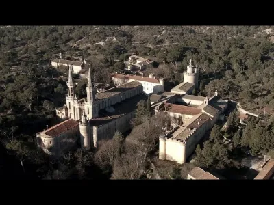
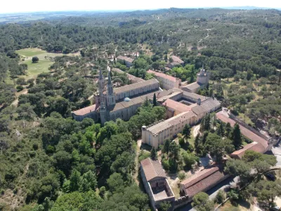
Located on a strategic trade and political route, overlooking the Rhône valley, at the border between the County of Provence and the Kingdom of France and crossing important roads of the time, the château de Boulbon was considered from its construction as a sentinel of Provence.
The oldest part of the château is probably the keep, the central rectangular tower dating back to the 11th century. The curtain wall, surrounding the keep and perfectly following the rock, dates from the 13th century, while the machicolations seem later (14th century). The latter, decorated with trefoil motifs, are similar to those crowning the royal château of Tarascon. It was only at the end of the 14th century that the lords' residence and the large terrace on the west side were built.
In the 17th century the château saw the development of its terraced gardens and the carriage road leading to the North gate.
Gaston de Raousset-Boulbon, owner of the château in the 19th century The château de Boulbon has belonged to many different owners since its construction. Raymond de Turenne and King René are examples in the 15th century. In 1608, the lordship of Boulbon was raised to a county. Then, in 1784, it passed to the Raousset-Boulbon family, who kept it until the 19th century. From the beginning of the 19th century, the château itself was no longer habitable. Gaston de Raousset-Boulbon, after squandering the family fortune, tried to settle in French Algeria, then being colonized, and later was a key figure in the founding of the Republic of Sonora in Mexico in the 1850s, before being shot there. The last count of Boulbon, Gaston de Raousset, died in Boulbon without direct descendants in 1956. The château currently belongs to the Bonaparte-Wyse family.
Architecture The whole listed site is now in ruins, mainly because of the looting it suffered from the moment it ceased to be occupied.
The keep originally had four levels, one of which is recessed, built directly into the rock.
In the main body of the château, the lord's residence, built in the 14th century, consists of a vast building of two floors under an attic, housing no fewer than 30 rooms.
The remains of a double-flight staircase are still visible in the central part, from one of the south gardens. A water buffet and remains of carved rockwork decoration are also visible there.
Traces of a fairly elaborate water supply system are still visible all along the site. From a spring tapped in the 15th century, a network of glazed terracotta pipes (a few pieces are located to the left of the entrance to the estate) brought water to the living quarters, where it flowed into small settling basins. On the remaining walls of the lord's residence, you can make out the channel that housed the pipes. The overflow ran below the terraces into wash houses.
Maintenance work is still ongoing, in particular to consolidate the walls, the 17th-century arches, and to explore the small fort.
Additional information The site is still private and visiting the ruins of the castle is not recommended for safety reasons.
The site sometimes hosts festive events, such as evenings of wall illumination by the local association Boulbon à l'Encre Sympathique.
Map and restricted areas
Open in the main mapNearby aerodromes
Open aerodromes within 25 km of the spot, heliports included, with their distance and direction from the spot. Near an aerodrome, drone flying is prohibited or height-limited: check the UAS zones map.
| Aerodrome | Type | Distance | Elevation | Difference |
|---|---|---|---|---|
| Centre Hospitalier Heliport | Heliport | 10 km NE | 21 m | spot 30 m higher |
| Aérodrome d'Avignon-Pujaut | Aerodrome | 16 km N | 45 m | spot 6 m higher |
| Avignon-Caumont Airport | Airport | 17 km E | 38 m | spot 14 m higher |
| Le Mazet De Romanin Airfield | Aerodrome | 19 km SE | 118 m | spot 67 m lower |
| Nîmes Courbessac Airport | Aerodrome | 23 km W | 60 m | spot 9 m lower |
Aviation weather (METAR and TAF)
LFMV – Avignon-Caumont Airport VFR
METAR
METAR LFMV 210900Z AUTO 00000KT CAVOK 08/07 Q1021 NOSIG
- Wind
- Calm
- Visibility
- 10 km or more
- Clouds
- –
- Temperature
- 8 °C, dew point 7 °C
- QNH
- 1021 hPa
- Flight category
- VFR: ceiling > 3,000 ft and visibility > 5 mi
TAF
TAF LFMV 210800Z 2109/2209 VRB03KT CAVOK TEMPO 2119/2209 4000 SHRA BKN012 BKN025TCU BECMG 2121/2123 12010KT
| Period (local time) | Change | Wind | Visibility | Weather | Clouds |
|---|---|---|---|---|---|
| 21/11 10:00 → 21/11 22:00 | Initial conditions | Variable, 6 km/h | 10 km or more | No significant weather | No significant cloud |
| 21/11 20:00 → 22/11 10:00 | Temporarily | 4.0 km | Showers of rain | Broken (5-7/8) at 1,200 ft (370 m) ; Broken (5-7/8) at 2,500 ft (760 m) (towering cumulus) | |
| 21/11 22:00 → 22/11 10:00 | Becoming | 120°, 19 km/h | 10 km or more | No significant weather | No significant cloud |
Weather and Kp index
Sunrise and sunset
| Day | Dawn | Sunrise | Golden hour | Sunset | Dusk | Day length |
|---|---|---|---|---|---|---|
| Sat 21 Nov | 07:12 | 07:43 | 07:43–08:28 · 16:26–17:11 | 17:11 | 17:42 | 9 h 27 |
| Sun 22 Nov | 07:13 | 07:45 | 07:45–08:29 · 16:25–17:10 | 17:10 | 17:41 | 9 h 25 |
| Mon 23 Nov | 07:14 | 07:46 | 07:46–08:31 · 16:24–17:09 | 17:09 | 17:41 | 9 h 23 |
| Tue 24 Nov | 07:16 | 07:47 | 07:47–08:32 · 16:24–17:09 | 17:09 | 17:40 | 9 h 21 |
| Wed 25 Nov | 07:17 | 07:48 | 07:48–08:34 · 16:23–17:08 | 17:08 | 17:40 | 9 h 19 |
| Thu 26 Nov | 07:18 | 07:50 | 07:50–08:35 · 16:22–17:07 | 17:07 | 17:39 | 9 h 17 |
| Fri 27 Nov | 07:19 | 07:51 | 07:51–08:36 · 16:21–17:07 | 17:07 | 17:39 | 9 h 16 |



Reviews
Log in to review this spot. Log in · Create a free account
No reviews yet. Share yours!