

Aigues Mortes

No reviews yet
Have you flown here? Share your experience with other pilots.
+ Write the first reviewDescription
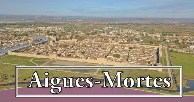
Aigues-Mortes, in Occitan Aigas-Mòrtas, in Provençal Aigua Morta, is a French commune of the Petite Camargue, located at the southern tip of the Gard department, in the Occitanie region.
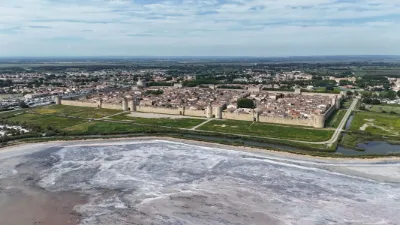
It is renowned for its ramparts and its arena, called the Plan des Théâtres and used for Camargue bull races, and is also sadly famous for the Massacre of the Italians that took place in August 1893. The commune's architectural heritage includes three buildings protected as historic monuments: the Hôtel de Grailhe, listed in 1994, the chapel of the Château de Roquelaure, listed in 2007, and four houses, registered in 1903, 1949 and 1993 respectively.
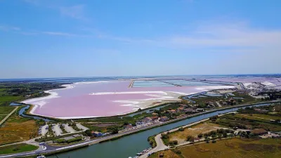
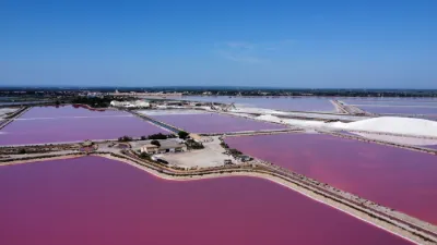
The Salins d'Aigues-Mortes, which operate the Peccais marsh, emblematic of Camargue salt production, are also located within the commune.
Its inhabitants are called Aigues-Mortais and Aigues-Mortaises, and aigamortencs in Occitan. The commune's territory is made up of part of the wet plain and the ponds of the Petite Camargue, the largest of which are the étang du Roy to the southeast, the étang de la Ville immediately south of Aigues-Mortes, part of the étang de Caitives, the rest of which lies in Saint-Laurent-d'Aigouze, the étang de la Marette to the southwest of the town, and about 63 hectares of the étang de Mauguio to the west.
To the southwest, it is separated from the Gulf of Lion (Mediterranean Sea) by the commune of Le Grau-du-Roi. Aigues-Mortes is nevertheless connected to the sea by the Grau-du-Roi canal. The communes of Saint-Laurent-d'Aigouze and Le Grau-du-Roi therefore border Aigues-Mortes.
To the west, the commune touches Mauguio (Hérault) at a corner of its boundary, brushing it at the pointe de la Radelle in the étang de Mauguio. To the southeast, it shares a border with Les Saintes-Maries-de-la-Mer over about 800 m.
The whole southern half of the commune is occupied by salt works, ponds and marshes, which are also largely dominant in the northern part. As a result, there are only very few hamlets: Corbière, mas du Bosquet, mas du grand Môle, mas du Petit Chaumont and mazet de Bel-Air1.
Aigues-Mortes is one of the 81 member communes of the Schéma de cohérence territoriale (Scot) du Sud du Gard and is also one of the 34 communes of the pays Vidourle-Camargue. Aigues-Mortes is also one of the four "Loi littoral" communes of the Scot du Sud du Gard.
Gallician is located in the heart of the Petite Camargue, at the foot of the Costières plateau, on the banks of the Canal du Rhône à Sète and the étang de Scamandre.
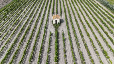
With about 1,000 inhabitants, Gallician lives mainly from winegrowing - AOC Costières-de-Nîmes - its main activity, to which fishing and the "sagne", that is, reed cutting, can also be added. With a marina and a boating stopover, Gallician lies on the banks of the Canal du Rhône à Sète, a canal used by both tourist boats and barges. The Bas-Rhône Languedoc irrigation canal runs north of the hamlet. The Vauvert-Gallician greenway follows it for 7 km between these two localities.
The Scamandre regional nature reserve is located at the place called Les Iscles, in the territory of the hamlet of Gallician. Throughout the feudal period, the marshes were the property of the Baron of Posquières-Vauvert, but the inhabitants of the commune held some rights of use there, notably for harvesting reeds and fishing.
In the 1770s-80s, a family from Vauvert, the "Gallissian" family, set up a hut on the road from Saint-Gilles to Aigues-Mortes, at the edge of the marshes at the junction of the ditch coming from the mas de Beck. On the 1800 Cassini map, this ditch is named "Val Gallissian", which confirms the presence of the Gallissian family's properties at this place. The creation of the navigation canal and the bridge at the end of the 18th century favored the development of agricultural, craft and commercial activities at Gallissian.
At the end of the 19th century, the land registry administrators changed the spelling of Gallissian to "Gallician"1.
Map and restricted areas
Open in the main mapNearby aerodromes
Open aerodromes within 25 km of the spot, heliports included, with their distance and direction from the spot. Near an aerodrome, drone flying is prohibited or height-limited: check the UAS zones map.
| Aerodrome | Type | Distance | Elevation | Difference |
|---|---|---|---|---|
| Aérodrome de Montpellier - Candillargues | Aerodrome | 10 km NW | 2 m | same altitude as the spot |
| Montpellier-Méditerranée Airport | Airport | 18 km W | 5 m | same altitude as the spot |
| Le Corum Heliport | Heliport | 25 km W | 54 m | spot 52 m lower |
Aviation weather (METAR and TAF)
LFMT – Montpellier-Méditerranée Airport VFR
METAR
METAR LFMT 210630Z AUTO 28004KT CAVOK 11/08 Q1020 NOSIG
- Wind
- 280°, 7 km/h
- Visibility
- 10 km or more
- Clouds
- –
- Temperature
- 11 °C, dew point 8 °C
- QNH
- 1020 hPa
- Flight category
- VFR: ceiling > 3,000 ft and visibility > 5 mi
TAF
TAF LFMT 210200Z 2103/2203 27010KT 9999 FEW050 BECMG 2109/2112 07010KT BECMG 2119/2121 03010KT BKN010
| Period (local time) | Change | Wind | Visibility | Weather | Clouds |
|---|---|---|---|---|---|
| 21/11 04:00 → 21/11 10:00 | Initial conditions | 270°, 19 km/h | 10 km or more | Few (1-2/8) at 5,000 ft (1520 m) | |
| 21/11 10:00 → 21/11 20:00 | Becoming | 070°, 19 km/h | 10 km or more | Few (1-2/8) at 5,000 ft (1520 m) | |
| 21/11 20:00 → 22/11 04:00 | Becoming | 030°, 19 km/h | 10 km or more | Broken (5-7/8) at 1,000 ft (300 m) |
Weather and Kp index
| Day | Weather | Temp. min. / max. | Wind | Rain | Max Kp |
|---|---|---|---|---|---|
| Sat 21 Nov | Partly cloudy | 9° / 16° | 20 km/h NE | 0.3 mm | 2 |
| Sun 22 Nov | Partly cloudy | 12° / 16° | 40 km/h W | 1.3 mm | 2 |
| Mon 23 Nov | Fair | 10° / 15° | 32 km/h W | – | 4 |
| Tue 24 Nov | Cloudy | 5° / 10° | 11 km/h NE | 11 mm | 2 |
| Wed 25 Nov | Rain | 8° / 12° | 33 km/h E | 58 mm | – |
| Thu 26 Nov | Clear sky | 4° / 12° | 4 km/h N | – | – |
| Fri 27 Nov | Clear sky | 4° / 11° | 6 km/h N | – | – |
Hour by hour: Saturday 21 November
| Time | Weather | Temp. | Wind | Rain | Clouds | Kp |
|---|---|---|---|---|---|---|
| 08:00 | Cloudy | 9° | 6 km/h N | – | 99 % | 2 |
| 09:00 | Cloudy | 10° | 6 km/h NE | – | 98 % | 2 |
| 10:00 | Cloudy | 11° | 8 km/h N | – | 99 % | 2 |
| 11:00 | Partly cloudy | 13° | 6 km/h NW | – | 78 % | 2 |
| 12:00 | Partly cloudy | 14° | 6 km/h NW | – | 74 % | 2 |
| 13:00 | Partly cloudy | 15° | 4 km/h NE | – | 88 % | 1 |
| 14:00 | Partly cloudy | 16° | 4 km/h E | – | 80 % | 1 |
| 15:00 | Partly cloudy | 16° | 6 km/h E | – | 50 % | 1 |
| 16:00 | Partly cloudy | 16° | 10 km/h E | – | 77 % | 2 |
| 17:00 | Cloudy | 13° | 13 km/h E | – | 98 % | 2 |
| 18:00 | Cloudy | 12° | 15 km/h E | – | 88 % | 2 |
| 19:00 | Cloudy | 12° | 16 km/h E | – | 98 % | 2 |
| 20:00 | Cloudy | 12° | 17 km/h E | – | 98 % | 2 |
| 21:00 | Cloudy | 12° | 19 km/h E | – | 100 % | 2 |
| 22:00 | Light rain | 12° | 20 km/h NE | 0.3 mm | 100 % | 2 |
Hour by hour: Sunday 22 November
| Time | Weather | Temp. | Wind | Rain | Clouds | Kp |
|---|---|---|---|---|---|---|
| 06:00 | Cloudy | 15° | 16 km/h SW | – | 100 % | 2 |
| 07:00 | Cloudy | 14° | 15 km/h W | – | 91 % | 2 |
| 08:00 | Partly cloudy | 13° | 18 km/h W | – | 59 % | 2 |
| 09:00 | Showers | 14° | 27 km/h W | 0.1 mm | 72 % | 2 |
| 10:00 | Cloudy | 15° | 31 km/h W | – | 98 % | 2 |
| 11:00 | Partly cloudy | 15° | 33 km/h W | – | 45 % | 2 |
| 12:00 | Fair | 16° | 40 km/h W | – | 28 % | 2 |
| 13:00 | Partly cloudy | 16° | 37 km/h W | – | 41 % | 2 |
| 14:00 | Fair | 16° | 39 km/h W | – | 23 % | 2 |
| 15:00 | Fair | 15° | 39 km/h W | – | 27 % | 2 |
| 16:00 | Fair | 14° | 36 km/h W | – | 27 % | 2 |
| 17:00 | Fair | 14° | 31 km/h W | – | 32 % | 2 |
| 18:00 | Partly cloudy | 13° | 29 km/h W | – | 79 % | 2 |
| 19:00 | Partly cloudy | 13° | 31 km/h W | – | 43 % | 2 |
| 20:00 | Partly cloudy | 13° | 31 km/h W | – | 59 % | 2 |
| 21:00 | Partly cloudy | 12° | 31 km/h W | – | 50 % | 2 |
| 22:00 | Fair | 12° | 28 km/h W | – | 34 % | 2 |
Sunrise and sunset
| Day | Dawn | Sunrise | Golden hour | Sunset | Dusk | Day length |
|---|---|---|---|---|---|---|
| Sat 21 Nov | 07:13 | 07:45 | 07:45–08:29 · 16:29–17:14 | 17:14 | 17:45 | 9 h 28 |
| Sun 22 Nov | 07:15 | 07:46 | 07:46–08:30 · 16:28–17:13 | 17:13 | 17:44 | 9 h 26 |
| Mon 23 Nov | 07:16 | 07:47 | 07:47–08:32 · 16:28–17:12 | 17:12 | 17:44 | 9 h 24 |
| Tue 24 Nov | 07:17 | 07:48 | 07:48–08:33 · 16:27–17:12 | 17:12 | 17:43 | 9 h 23 |
| Wed 25 Nov | 07:18 | 07:50 | 07:50–08:34 · 16:26–17:11 | 17:11 | 17:42 | 9 h 21 |
| Thu 26 Nov | 07:19 | 07:51 | 07:51–08:36 · 16:25–17:10 | 17:10 | 17:42 | 9 h 19 |
| Fri 27 Nov | 07:20 | 07:52 | 07:52–08:37 · 16:25–17:10 | 17:10 | 17:42 | 9 h 17 |

Reviews
Log in to review this spot. Log in · Create a free account
No reviews yet. Share yours!