

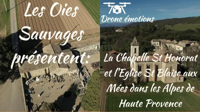
Les Mées, the Chapelle Saint Honorat and the Saint Blaise church
No reviews yet
Have you flown here? Share your experience with other pilots.
+ Write the first reviewDescription
The Saint-Honorat chapel, or Saint-Blaise Priory, is a Romanesque chapel located at the place called Les Petits Camps in Les Mées, in the French department of Alpes-de-Haute-Provence. The first mention of this priory is given by Bartel: a benefice or rural priory under the patronage of Saint Blaise in agro Mediarum, dependent on the mensa of the abbey of Boscodon. Féraud makes it the parish church of Plan-des-Mées. Abbayes et Prieurés also make it dependent on Boscodon, the Saint-Blaise priory of Palleirosc, dependent on Boscaudon. G. Barruol makes it a dependency of the Order of the Temple in the middle of the 13th century and describes it as follows: the church of this establishment, under the title of Saint-Blaise.
According to a few brief records, this chapel was the parish church of Plan-des-Mées. This is what is stated on 9 November 1891 during a pastoral visit: rural chapel St-Honorat, former parish church, in ruins, and reaffirmed in 1894: rural chapel, the former church of St-Honorat. Repairs seem to have been carried out, because in 1899: Saint-Honorat chapel, former parish church, several centuries old. Mass 3 or 4 times a year. R. Collier gives the description: the Saint-Honorat chapel, near Paillerols (a district of Les Mées), which must once have depended on the abbey of Boscodon, to which the Paillerols estate belonged, shows Romanesque structures; the nave, the arms of the false transept and the flat chevet are covered with semicircular vaults. A fine, massive monolithic tympanum, carved with an anchored cross, surmounts the west door; the window frames and the pilasters may also date back to the 13th century1.
The building has been listed as a historic monument since 20 January 19832
Architecture The chapel is well preserved but abandoned. It is a cruciform building from the early 13th century. The nave, the arms of the false transept and the sanctuary, where the original table altar is still in place, are covered with semicircular vaults. Two doors give access to the building: the west one, which borders the public road, is topped by a powerful monolithic lintel and a false tympanum decorated with a beautiful anchored cross in bas-relief…; the south one connects the nave with the cemetery, which now extends widely around the monument; a single bay, widely splayed toward the inside, lights the building.
The Church of St Blaise In 1870, the church was built to replace that of Saint-Honorat, which had become too small. It is dedicated to Saint Blaise, the patron saint of the hamlet of Dabisse, and placed under the patronage of the "Sacré-Coeur". Of pure Gothic style, the church depends on the monastery of Paillerols, and is thus attached to Boscodon.
The twelve stained-glass windows depict various figures and motifs. The central window of the choir shows Christ, with the Virgin Mary on his right and Saint Joseph on his left. The other two windows of the choir depict Saint Henry (in memory of Henri Raibaud L'ange, former Mayor of Les Mées and a major donor) and Saint Louis, King of France. The windows of the nave depict the apostles, and the window of the side chapel shows two saints: Stephen and Charles Borromeo. The church also has a rose window decorated with stained glass above its forecourt.
Map and restricted areas
Open in the main mapNearby aerodromes
Open aerodromes within 25 km of the spot, heliports included, with their distance and direction from the spot. Near an aerodrome, drone flying is prohibited or height-limited: check the UAS zones map.
| Aerodrome | Type | Distance | Elevation | Difference |
|---|---|---|---|---|
| Aérodrome de Château-Arnoux - Saint-Auban | Aerodrome | 11 km NE | 460 m | spot 83 m lower |
| Puimoisson Airfield | Aerodrome | 21 km SE | 769 m | spot 392 m lower |
Aviation weather (METAR and TAF)
No METAR station within 50 km.
Weather and Kp index
Sunrise and sunset
| Day | Dawn | Sunrise | Golden hour | Sunset | Dusk | Day length |
|---|---|---|---|---|---|---|
| Sat 21 Nov | 07:07 | 07:39 | 07:39–08:23 · 16:21–17:05 | 17:05 | 17:37 | 9 h 26 |
| Sun 22 Nov | 07:09 | 07:40 | 07:40–08:25 · 16:20–17:05 | 17:05 | 17:36 | 9 h 24 |
| Mon 23 Nov | 07:10 | 07:41 | 07:41–08:26 · 16:19–17:04 | 17:04 | 17:36 | 9 h 22 |
| Tue 24 Nov | 07:11 | 07:43 | 07:43–08:28 · 16:18–17:03 | 17:03 | 17:35 | 9 h 20 |
| Wed 25 Nov | 07:12 | 07:44 | 07:44–08:29 · 16:17–17:03 | 17:03 | 17:35 | 9 h 18 |
| Thu 26 Nov | 07:13 | 07:45 | 07:45–08:30 · 16:17–17:02 | 17:02 | 17:34 | 9 h 17 |
| Fri 27 Nov | 07:14 | 07:46 | 07:46–08:32 · 16:16–17:02 | 17:02 | 17:34 | 9 h 15 |


Reviews
Log in to review this spot. Log in · Create a free account
No reviews yet. Share yours!