

Gignac la Nerthe, La Chapelle St Michel

No reviews yet
Have you flown here? Share your experience with other pilots.
+ Write the first reviewDescription
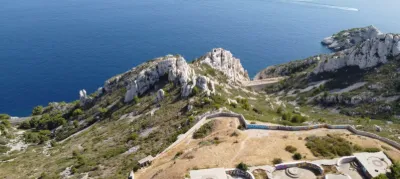
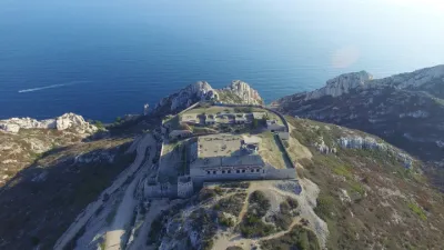
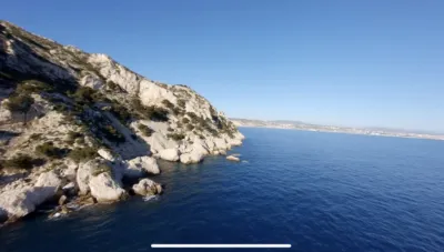
Although it stands on the hill a few steps from Gignac-la-Nerthe, anchored on a rocky outcrop, the chapel is in the municipality of Le Rove. Dating from the 12th and 13th centuries, it marks the early beginnings of the Provençal Gothic style. The fortified chapel of the castle, of which only a section of wall remains, it was known as "Sainte-Marthe & Saint-Michel" and belonged to the Templars, who held a military commandery here. The Hospitallers of Jerusalem settled there after the Templars abandoned the site in 1309. In 1388, Raymond de Turenne spared it while he destroyed everything around it: houses, castle and ramparts. The small bell tower dates from the 17th century. Unused since the 18th century and restored in 1874, it has been listed as a historic monument since 29 July 1977. Today, it overlooks the protected natural area of "la Côte Bleue" and is part of the Natura 2000 programme "Côte bleue - Chaîne de l'Estaque". It also overlooks the motorway and is immersed in the endless ballet of planes landing at Marignane. Hiking trails criss-cross the massif… and so do the EDF pylons.
Easy and quick access. Park in Gignac, rue Honoré Daumier. Four steps and the hill is yours once you have crossed the bridge under the motorway. The draille, a narrow, steep path, is more of a workout if you want to climb straight up; otherwise, the DFCI tracks lead there at a leisurely pace. Good shoes and poles may be useful, as some tracks are stony.
Map and restricted areas
Open in the main mapNearby aerodromes
Open aerodromes within 25 km of the spot, heliports included, with their distance and direction from the spot. Near an aerodrome, drone flying is prohibited or height-limited: check the UAS zones map.
| Aerodrome | Type | Distance | Elevation | Difference |
|---|---|---|---|---|
| Marseille Provence Airport | Major airport | 6.3 km N | 23 m | spot 82 m higher |
| Berre/Marignane Seaplane Base | Seaplane base | 7.6 km N | 2 m | spot 103 m higher |
| Nord Heliport | Heliport | 10 km E | 187 m | spot 82 m lower |
| Marseille Hydro | Seaplane base | 13 km SE | 0 m | spot 105 m higher |
| Base Hydro-ULM "Henri Fabre" | Seaplane base | 13 km W | 0 m | spot 105 m higher |
Aviation weather (METAR and TAF)
LFML – Marseille Provence Airport VFR
METAR
METAR LFML 211130Z AUTO VRB02KT 9999 2600 NSC 15/08 Q1019 NOSIG
- Wind
- Variable, 4 km/h
- Visibility
- 10 km or more
- Clouds
- –
- Temperature
- 15 °C, dew point 8 °C
- QNH
- 1019 hPa
- Flight category
- VFR: ceiling > 3,000 ft and visibility > 5 mi
TAF
TAF LFML 210800Z 2109/2215 VRB03KT CAVOK TX17/2117Z TN13/2205Z BECMG 2116/2118 12010KT BECMG 2119/2121 -SHRA TEMPO 2120/2209 4000 SHRA BKN012 BKN025TCU BECMG 2208/2210 26020G35KT NSW
| Period (local time) | Change | Wind | Visibility | Weather | Clouds |
|---|---|---|---|---|---|
| 21/11 10:00 → 21/11 17:00 | Initial conditions | Variable, 6 km/h | 10 km or more | No significant cloud | |
| 21/11 17:00 → 21/11 20:00 | Becoming | 120°, 19 km/h | 10 km or more | No significant cloud | |
| 21/11 20:00 → 22/11 09:00 | Becoming | 120°, 19 km/h | 10 km or more | Showers of rain light | No significant cloud |
| 21/11 21:00 → 22/11 10:00 | Temporarily | 4.0 km | Showers of rain | Broken (5-7/8) at 1,200 ft (370 m) ; Broken (5-7/8) at 2,500 ft (760 m) (towering cumulus) | |
| 22/11 09:00 → 22/11 16:00 | Becoming | 260°, 37 km/h, gusts 65 km/h | 10 km or more | No significant weather | No significant cloud |
Weather and Kp index
Sunrise and sunset
| Day | Dawn | Sunrise | Golden hour | Sunset | Dusk | Day length |
|---|---|---|---|---|---|---|
| Sat 21 Nov | 07:09 | 07:40 | 07:40–08:24 · 16:26–17:10 | 17:10 | 17:41 | 9 h 29 |
| Sun 22 Nov | 07:10 | 07:41 | 07:41–08:25 · 16:25–17:09 | 17:09 | 17:40 | 9 h 27 |
| Mon 23 Nov | 07:11 | 07:42 | 07:42–08:27 · 16:24–17:08 | 17:08 | 17:40 | 9 h 26 |
| Tue 24 Nov | 07:12 | 07:44 | 07:44–08:28 · 16:23–17:08 | 17:08 | 17:39 | 9 h 24 |
| Wed 25 Nov | 07:13 | 07:45 | 07:45–08:29 · 16:23–17:07 | 17:07 | 17:39 | 9 h 22 |
| Thu 26 Nov | 07:14 | 07:46 | 07:46–08:31 · 16:22–17:07 | 17:07 | 17:38 | 9 h 20 |
| Fri 27 Nov | 07:16 | 07:47 | 07:47–08:32 · 16:21–17:06 | 17:06 | 17:38 | 9 h 19 |



Reviews
Log in to review this spot. Log in · Create a free account
No reviews yet. Share yours!