Skip to content
Unusual

Haut des beaux monts
Oise

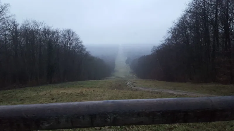
Haut des beaux monts – photo 1

No reviews yet

Have you flown here? Share your experience with other pilots.

+ Write the first review

Description

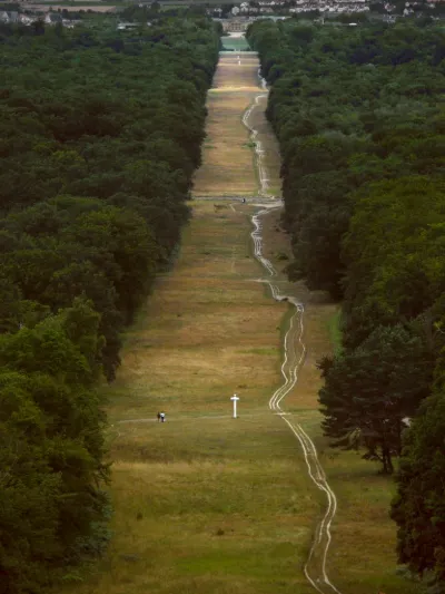
A view over the whole descent of the Beaux Monts facing the Compiègne palace. Magnificent sunset.

Automatic translation.

Map and restricted areas

Open in the main map

Nearby aerodromes

Open aerodromes within 25 km of the spot, heliports included, with their distance and direction from the spot. Near an aerodrome, drone flying is prohibited or height-limited: check the UAS zones map.

Aerodrome Type Distance ElevationDifference
Compiègne Margny Airfield Aerodrome 6.3 km NW 96 mspot 43 m lower
Centre Hospitalier Heliport Heliport 6.6 km W 33 mspot 20 m higher
Base ULM de Taillefontaine Aerodrome 17 km SE 145 mspot 92 m lower

Indicative list: it does not replace official aeronautical information.

Aviation weather (METAR and TAF)

No METAR station within 50 km.

METAR and TAF from NOAA (Aviation Weather Center), for guidance only: they do not replace flight planning with official sources (SIA, Météo-France). Nearest station that issues a METAR, not necessarily the nearest aerodrome.

Plan the light

Weather and Kp index

Loading forecast…

Sunrise and sunset

Local times at the spot (UTC+01:00). The golden hour, the warm, low light sought after for photos and videos, runs from sunrise until the sun reaches 6° above the horizon, and in the evening from 6° until sunset.

Day Dawn Sunrise Golden hour Sunset Dusk Day length
Sat 21 Nov07:33 08:09 08:09–09:00 · 16:08–17:00 17:00 17:368 h 51
Sun 22 Nov07:34 08:10 08:10–09:02 · 16:07–16:59 16:59 17:358 h 49
Mon 23 Nov07:36 08:12 08:12–09:04 · 16:06–16:58 16:58 17:348 h 46
Tue 24 Nov07:37 08:13 08:13–09:06 · 16:05–16:57 16:57 17:338 h 44
Wed 25 Nov07:38 08:14 08:14–09:07 · 16:04–16:56 16:56 17:328 h 41
Thu 26 Nov07:40 08:16 08:16–09:09 · 16:03–16:56 16:56 17:328 h 39
Fri 27 Nov07:41 08:17 08:17–09:11 · 16:02–16:55 16:55 17:318 h 37

Nearby on Wikipedia

  • Clairière de lArmistice · 2.8 km away
  • Ligne de démarcation · 2.8 km away

    La ligne de démarcation (en allemand Demarkationslinie, parfois contracté en Dema-Linie voire en DemaÉric Alary, La Ligne de démarcation : 1940-1944, éd. Perrin, Paris, 2003, 429 , .) est en France, pendant la Seconde Guerre mondiale, la limite entre la zone occupée par l'Armée allemande et la zone (...)

  • Armistice du 22 juin 1940 · 2.8 km away

    L’armistice du 22 juin 1940 est une convention signée en forêt de Compiègne entre le représentant du Troisième Reich allemand et celui du gouvernement français de Philippe Pétain afin de mettre fin aux hostilités ouvertes par la déclaration de guerre de la France envers l'Allemagne le , marquées (...)

  • Armistice de 1918 · 2.8 km away

    L’armistice de 1918, signé le à , sur le site Herodote.net, consulté le 18 janvier 2010., sur le site cheminsdememoire.gouv.fr., marque la fin des combats de la Première Guerre mondiale (1914-1918), la victoire des Alliés et la défaite totale de l'Allemagne, mais il ne s'agit pas d'une capitulation (...)

  • Golf de Compiègne · 2.9 km away

    Le Golf de Compiègne est situé à Compiègne (Oise). Il a été dessiné par l'architecte britannique Smith. (...)

Articles found by GeoNames from the spot's position.

Nearby spots

Reviews

Log in to review this spot. Log in · Create a free account

No reviews yet. Share yours!

Connection to the site lost. Trying again…

The site is not responding. Trying again in seconds.

The site is no longer responding.

The site has been updated. Reloading the page…

This page has expired.

Resuming failed. Please reload the page.

The site is no longer responding.