

Île des Allivoz

No reviews yet
Have you flown here? Share your experience with other pilots.
+ Write the first reviewDescription
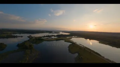
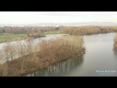
Several beaches are available around this island, and most are well suited for taking off with a drone (flat terrain, clear sky). On weekdays during the holidays you may find a few people in the morning and at midday, but more rarely in the afternoon. In terms of restrictions, this zone is limited to a maximum altitude of 30 meters. You need to stay within a perimeter of about 600 meters of the island so as not to fly over the quarry located a little further away or run into one of the high-voltage lines around the lake. In short, it's best to stay over the water, but that already lets you capture some fairly interesting shots.
Map and restricted areas
Open in the main mapNearby aerodromes
Open aerodromes within 25 km of the spot, heliports included, with their distance and direction from the spot. Near an aerodrome, drone flying is prohibited or height-limited: check the UAS zones map.
| Aerodrome | Type | Distance | Elevation | Difference |
|---|---|---|---|---|
| Lyon-Bron Airport | Airport | 8.3 km S | 201 m | spot 29 m lower |
| Hôpital Edouard-Herriot Heliport | Heliport | 9.4 km SW | 199 m | spot 27 m lower |
| Lyon Saint-Exupéry Airport | Major airport | 11 km SE | 250 m | spot 78 m lower |
| Aérodrome de Lyon - Corbas | Aerodrome | 17 km S | 198 m | spot 26 m lower |
| Aérodrome de Pérouges - Meximieux | Aerodrome | 18 km NE | 214 m | spot 42 m lower |
Aviation weather (METAR and TAF)
LFLY – Lyon-Bron Airport VFR
METAR
METAR LFLY 211000Z AUTO 13004KT 100V160 9999 FEW002 12/10 Q1021 NOSIG
- Wind
- 130°, 7 km/h
- Visibility
- 10 km or more
- Clouds
- Few (1-2/8) at 200 ft (60 m)
- Temperature
- 12 °C, dew point 10 °C
- QNH
- 1021 hPa
- Flight category
- VFR: ceiling > 3,000 ft and visibility > 5 mi
TAF
TAF LFLY 210500Z 2106/2206 15006KT CAVOK PROB40 TEMPO 2106/2108 5000 -RA BKN040 TEMPO 2200/2205 4000 RA OVC035 PROB40 TEMPO 2203/2206 15015KT BKN014
| Period (local time) | Change | Wind | Visibility | Weather | Clouds |
|---|---|---|---|---|---|
| 21/11 07:00 → 22/11 07:00 | Initial conditions | 150°, 11 km/h | 10 km or more | No significant weather | No significant cloud |
| 21/11 07:00 → 21/11 09:00 | Temporarily, probability 40% | 5 km | Rain light | Broken (5-7/8) at 4,000 ft (1220 m) | |
| 22/11 01:00 → 22/11 06:00 | Temporarily | 4.0 km | Rain | Overcast (8/8) at 3,500 ft (1070 m) | |
| 22/11 04:00 → 22/11 07:00 | Temporarily, probability 40% | 150°, 28 km/h | Broken (5-7/8) at 1,400 ft (430 m) |
Weather and Kp index
| Day | Weather | Temp. min. / max. | Wind | Rain | Max Kp |
|---|---|---|---|---|---|
| Sat 21 Nov | Partly cloudy | 7° / 13° | 8 km/h SE | – | 2 |
| Sun 22 Nov | Heavy rain | 8° / 12° | 23 km/h SE | 22 mm | 2 |
| Mon 23 Nov | Cloudy | 4° / 10° | 21 km/h W | 4.0 mm | 4 |
| Tue 24 Nov | Cloudy | -1° / 4° | 12 km/h N | – | 2 |
| Wed 25 Nov | Heavy rain | 3° / 5° | 11 km/h SE | 19 mm | – |
| Thu 26 Nov | Cloudy | 4° / 8° | 9 km/h SE | 7.0 mm | – |
| Fri 27 Nov | Cloudy | 3° / 6° | 3 km/h SE | – | – |
Hour by hour: Saturday 21 November
| Time | Weather | Temp. | Wind | Rain | Clouds | Kp |
|---|---|---|---|---|---|---|
| 11:00 | Partly cloudy | 10° | 7 km/h E | – | 51 % | 2 |
| 12:00 | Partly cloudy | 11° | 7 km/h E | – | 51 % | 2 |
| 13:00 | Partly cloudy | 12° | 7 km/h SE | – | 47 % | 1 |
| 14:00 | Partly cloudy | 13° | 6 km/h SE | – | 48 % | 1 |
| 15:00 | Partly cloudy | 13° | 5 km/h SE | – | 90 % | 1 |
| 16:00 | Partly cloudy | 12° | 2 km/h E | – | 84 % | 2 |
| 17:00 | Partly cloudy | 10° | 3 km/h N | – | 96 % | 2 |
| 18:00 | Partly cloudy | 9° | 4 km/h NE | – | 99 % | 2 |
| 19:00 | Partly cloudy | 8° | 5 km/h NE | – | 97 % | 2 |
| 20:00 | Partly cloudy | 8° | 2 km/h N | – | 98 % | 2 |
| 21:00 | Partly cloudy | 8° | 3 km/h E | – | 98 % | 2 |
| 22:00 | Cloudy | 7° | 6 km/h E | – | 98 % | 2 |
Hour by hour: Sunday 22 November
| Time | Weather | Temp. | Wind | Rain | Clouds | Kp |
|---|---|---|---|---|---|---|
| 06:00 | Heavy rain | 8° | 17 km/h SE | 3.6 mm | 100 % | 2 |
| 07:00 | Heavy rain | 8° | 21 km/h SE | 1.9 mm | 100 % | 2 |
| 08:00 | Heavy rain | 8° | 23 km/h SE | 1.4 mm | 100 % | 2 |
| 09:00 | Heavy rain | 8° | 18 km/h SE | 1.4 mm | 100 % | 2 |
| 10:00 | Light rain | 10° | 12 km/h SW | 0.2 mm | 100 % | 2 |
| 11:00 | Cloudy | 11° | 12 km/h W | – | 99 % | 2 |
| 12:00 | Heavy rain | 11° | 13 km/h SW | 2.1 mm | 98 % | 2 |
| 13:00 | Heavy rain | 10° | 15 km/h S | 3.4 mm | 100 % | 2 |
| 14:00 | Cloudy | 11° | 16 km/h SW | – | 87 % | 2 |
| 15:00 | Partly cloudy | 12° | 21 km/h W | – | 81 % | 2 |
| 16:00 | Partly cloudy | 12° | 19 km/h W | – | 77 % | 2 |
| 17:00 | Partly cloudy | 11° | 18 km/h W | – | 56 % | 2 |
| 18:00 | Partly cloudy | 10° | 17 km/h W | – | 70 % | 2 |
| 19:00 | Partly cloudy | 10° | 17 km/h SW | – | 68 % | 2 |
| 20:00 | Heavy rain | 9° | 21 km/h W | 1.0 mm | 99 % | 2 |
| 21:00 | Light rain | 9° | 20 km/h W | 0.4 mm | 99 % | 2 |
| 22:00 | Cloudy | 9° | 22 km/h W | – | 98 % | 2 |
Sunrise and sunset
| Day | Dawn | Sunrise | Golden hour | Sunset | Dusk | Day length |
|---|---|---|---|---|---|---|
| Sat 21 Nov | 07:15 | 07:48 | 07:48–08:35 · 16:17–17:04 | 17:04 | 17:36 | 9 h 15 |
| Sun 22 Nov | 07:17 | 07:49 | 07:49–08:36 · 16:16–17:03 | 17:03 | 17:36 | 9 h 13 |
| Mon 23 Nov | 07:18 | 07:51 | 07:51–08:38 · 16:15–17:02 | 17:02 | 17:35 | 9 h 11 |
| Tue 24 Nov | 07:19 | 07:52 | 07:52–08:39 · 16:14–17:01 | 17:01 | 17:34 | 9 h 09 |
| Wed 25 Nov | 07:20 | 07:53 | 07:53–08:41 · 16:13–17:01 | 17:01 | 17:34 | 9 h 07 |
| Thu 26 Nov | 07:21 | 07:55 | 07:55–08:42 · 16:13–17:00 | 17:00 | 17:33 | 9 h 05 |
| Fri 27 Nov | 07:23 | 07:56 | 07:56–08:44 · 16:12–17:00 | 17:00 | 17:33 | 9 h 03 |




Reviews
Log in to review this spot. Log in · Create a free account
No reviews yet. Share yours!