Skip to content
Water

Black Lake Mine
Canada

Black Lake Mine – photo 1

No reviews yet

Have you flown here? Share your experience with other pilots.

+ Write the first review

Description

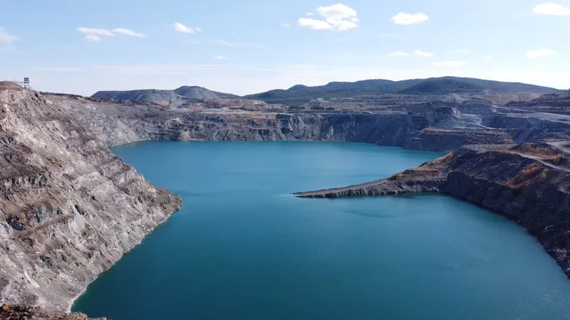
Former Black Lake mine turned into a lake. Windy, but a great spot with magnificent natural colors!

Automatic translation.

Aviation weather (METAR and TAF)

CWHV · 49 km NE ?

METAR

Observed 21/11 07:00 · 59 min ago

METAR CWHV 211200Z AUTO 13003KT 05/04 RMK AO1 SLP269 T00530037 53012

Wind
130°, 6 km/h
Visibility
–
Clouds
–
Temperature
5 °C, dew point 4 °C
Flight category
Unknown category

TAF

This station does not issue a TAF (or none is currently valid).

METAR and TAF from NOAA (Aviation Weather Center), for guidance only: they do not replace flight planning with official sources (SIA, Météo-France). Nearest station that issues a METAR, not necessarily the nearest aerodrome.

Plan the light

Weather and Kp index

Loading forecast…

Sunrise and sunset

Local times at the spot (UTC−05:00). The golden hour, the warm, low light sought after for photos and videos, runs from sunrise until the sun reaches 6° above the horizon, and in the evening from 6° until sunset.

Day Dawn Sunrise Golden hour Sunset Dusk Day length
Sat 21 Nov06:22 06:55 06:55–07:42 · 15:21–16:08 16:08 16:419 h 13
Sun 22 Nov06:23 06:56 06:56–07:43 · 15:20–16:07 16:07 16:409 h 11
Mon 23 Nov06:24 06:57 06:57–07:45 · 15:19–16:07 16:07 16:409 h 09
Tue 24 Nov06:25 06:58 06:58–07:46 · 15:18–16:06 16:06 16:399 h 07
Wed 25 Nov06:27 07:00 07:00–07:48 · 15:17–16:05 16:05 16:389 h 05
Thu 26 Nov06:28 07:01 07:01–07:49 · 15:17–16:05 16:05 16:389 h 03
Fri 27 Nov06:29 07:02 07:02–07:50 · 15:16–16:04 16:04 16:379 h 01

Nearby on Wikipedia

  • Black Lake · 0.1 km away

    Black Lake est un arrondissement de la ville québécoise de Thetford Mines, dans le sud de la province de Québec. Jusqu'au , Black Lake était une petite ville peuplée d'environ habitants. À cette date, les villes de Black Lake et de Thetford Mines, la municipalité de Pontbriand, la municipalité du (...)

  • Rivière Blanche (Thetford Mines) · 3.1 km away

    La rivière Blanche est un affluent de la rivière Bécancour, laquelle se déverse dans le fleuve Saint-Laurent. La rivière Blanche coule dans la municipalité de Thetford Mines, dans la municipalité régionale de comté (MRC) de Les Appalaches, dans la région administrative du Chaudière-Appalaches, au (...)

  • Réserve écologique de la Serpentine-de-Coleraine · 4.7 km away

    La réserve écologique de la Serpentine-de-Coleraine est située à Saint-Joseph-de-Coleraine près de Thetford Mines. C'est l'une des rares réserves écologiques où la visite est autorisée au grand public. La réserve protège plusieurs groupements forestiers rares au Québec (...)

  • Saint-Joseph-de-Coleraine · 7.3 km away

    Saint-Joseph-de-Coleraine est une municipalité du Québec située dans la municipalité régionale de comté de Appalaches et dans la région administrative de Chaudière-Appalaches. (...)

  • Les Appalaches · 7.6 km away

    Les Appalaches est une municipalité régionale de comté (MRC) du Québec dans la région de la Chaudière-Appalaches. Jusqu'au , elle était nommée « MRC de l'Amiante ». La ville principale est Thetford Mines et les municipalités locales constituant la MRC sont souvent référées collectivement par (...)

Articles found by GeoNames from the spot's position.

Nearby spots

Reviews

Log in to review this spot. Log in · Create a free account

No reviews yet. Share yours!

Connection to the site lost. Trying again…

The site is not responding. Trying again in seconds.

The site is no longer responding.

The site has been updated. Reloading the page…

This page has expired.

Resuming failed. Please reload the page.

The site is no longer responding.