

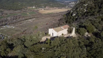
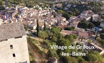
Gréoux les Bains, the Chapelle Notre Dame des Œufs.

No reviews yet
Have you flown here? Share your experience with other pilots.
+ Write the first reviewDescription
NOTRE-DAME DES ŒUFS Located on a hill on the left bank of the Verdon, facing the village of Gréoux, the site of Aurafrède was once a small fiefdom in its own right, later falling into the hands of the lords of Gréoux.
Located on a hill on the left bank of the Verdon, facing the village of Gréoux, the site of Aurafrède was once a small fiefdom in its own right, later falling into the hands of the lords of Gréoux. Etymologically, the place seems to take its name from the cold wind, a climatic feature due to the Verdon gorges. From the 15th century onward, the community of the place (Aurafrigida in the 13th century) was completely wiped out. All traces of life and human occupation disappeared, except for Notre-Dame d'Aurafrède, also called the Chapel of the Eggs or the Sanctuary of the Heights.
The history of the site, which is the highest and most rugged part of the territory of Gréoux, has been little studied. The expression found in a register of the diocese of Riez, "Prior Ecclesie Beate Marie de Aura Frigida", indicates a devotion to the Virgin Mary that may explain a legend long attached to this small religious building, which was once the object of a pagan cult.
Access to the sanctuary, an essential hiking destination, starts from Gréoux via rugged, winding paths. It is also possible, after crossing the bridge over the Verdon, to take a stretch of drivable road and finish on foot to discover a dazzling panorama and the building, the object of a pagan-Christian cult.
The preservation of Notre-Dame des Œufs, as we see it today, is to the credit of the "Amis de Gréoux". Thanks to a subscription, the association was able to restore the chapel and return it to worship.
Two pilgrimages take place there, on March 25 and September 8. These dates are no coincidence. The first, which is the day of the Annunciation, the announcement of the divine motherhood, can be moved if it falls during Lent. The second is the Nativity of the Virgin. To simplify things and encourage pilgrims to attend, the first celebration was held on Easter Monday, the first day after the end of the fast.
The chapel is a modest rectangular building about ten meters long by five wide, covered with a rubble barrel vault reinforced by a transverse arch of dressed stone. It is lit only by the basket-handle arched door topped with an oculus and by an arrow slit. The ruins of a hermitage are attached to its south side. Its last inhabitant, an eccentric man named Faure, claimed to be Louis XVII, escaped from the Temple.
The Sanctuary of the Heights is above all, following a very ancient rite widely condemned by the Church, a sanctuary of Fertility. During the spring pilgrimage, women wishing for a child would climb to the chapel carrying an egg in each hand. Once they reached the sanctuary, they would swallow one and bury the other. If they found it again in the fall, they were fertile.
It is not uncommon to find eggs at this site. It is even more common to find pleas there, requests concerning health and happiness, or thanks for a birth.
Map and restricted areas
Open in the main mapNearby aerodromes
Open aerodromes within 25 km of the spot, heliports included, with their distance and direction from the spot. Near an aerodrome, drone flying is prohibited or height-limited: check the UAS zones map.
| Aerodrome | Type | Distance | Elevation | Difference |
|---|---|---|---|---|
| Aérodrome de Vinon | Aerodrome | 11 km W | 275 m | spot 68 m higher |
| Puimoisson Airfield | Aerodrome | 24 km NE | 769 m | spot 426 m lower |
Aviation weather (METAR and TAF)
No METAR station within 50 km.
Weather and Kp index
Sunrise and sunset
| Day | Dawn | Sunrise | Golden hour | Sunset | Dusk | Day length |
|---|---|---|---|---|---|---|
| Sat 21 Nov | 07:07 | 07:38 | 07:38–08:23 · 16:22–17:06 | 17:06 | 17:37 | 9 h 27 |
| Sun 22 Nov | 07:08 | 07:40 | 07:40–08:24 · 16:21–17:05 | 17:05 | 17:37 | 9 h 25 |
| Mon 23 Nov | 07:09 | 07:41 | 07:41–08:25 · 16:20–17:05 | 17:05 | 17:36 | 9 h 23 |
| Tue 24 Nov | 07:10 | 07:42 | 07:42–08:27 · 16:19–17:04 | 17:04 | 17:36 | 9 h 22 |
| Wed 25 Nov | 07:12 | 07:43 | 07:43–08:28 · 16:18–17:03 | 17:03 | 17:35 | 9 h 20 |
| Thu 26 Nov | 07:13 | 07:44 | 07:44–08:30 · 16:18–17:03 | 17:03 | 17:35 | 9 h 18 |
| Fri 27 Nov | 07:14 | 07:46 | 07:46–08:31 · 16:17–17:02 | 17:02 | 17:34 | 9 h 16 |

Reviews
Log in to review this spot. Log in · Create a free account
No reviews yet. Share yours!