

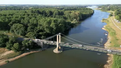
Pruniers Liberation Bridge
No reviews yet
Have you flown here? Share your experience with other pilots.
+ Write the first reviewDescription
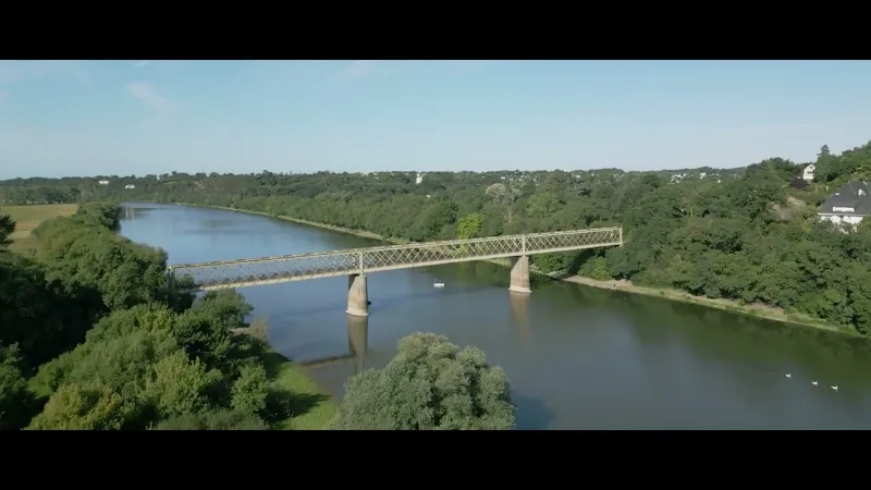
The Pruniers Bridge, also called the Petit Anjou bridge, is an engineering structure originally built for rail, spanning the Maine River at Bouchemaine, downstream from the city of Angers in Maine-et-Loire, France.
The bridge was built in 1908 to carry the secondary meter-gauge railway line of the departmental network known as the Petit Anjou, between Angers and Candé.
On August 8, 1944, the Allied troops, commanded by General Patton, arrived near Angers. The day before, German forces had blown up all the bridges across the Maine. Two young Frenchmen, Louis Bordier and Pierre-Yves Labbe, went to Saint-Jean-de-Linières, where the American forces were stationed, to inform them that the Pruniers bridge had not yet been destroyed by the enemy. However, the Germans had placed a wagon packed with explosives in the middle of the bridge so they could blow it up. Thanks to the information gathered, the Americans neutralized the German guard and took possession of the viaduct. This allowed the Allied forces to cross the Maine and attack the enemy troops from behind. Angers thus avoided an aerial bombardment. The German occupying forces withdrew very briefly to the commune of Sainte-Gemmes-sur-Loire, where they were dislodged after violent fighting caused by a German counterattack, which failed but cost the lives of more than a hundred American infantrymen.
The Angers - Candé line was permanently closed on August 20, 1947. The bridge is now reserved for pedestrians and cyclists.
Towards the end of the 1980s, a stele was erected on the left bank in tribute to the American troops who liberated Angers in 1944. On August 7, 1994, two other steles were erected on the right bank (esplanade Louis Bordier) in tribute to General Patton's soldiers and to the French Resistance.
- - - - - - - - - - - - - - - - - - - - - - - - - - - - - - - - - - - - - - - - - - - - - - - - - - - - - - - - - - - - - - - - - - - - - - - - - - - - - Spot: @47.4442533,-0.598458,17 Wiki: https://fr.wikipedia.org/wiki/Pont_de_Pruniers Gear: Dji Mini 3 Pro .Music: Arise - Roman P. (Artlist.io)
Map and restricted areas
Open in the main mapNearby aerodromes
Open aerodromes within 25 km of the spot, heliports included, with their distance and direction from the spot. Near an aerodrome, drone flying is prohibited or height-limited: check the UAS zones map.
| Aerodrome | Type | Distance | Elevation | Difference |
|---|---|---|---|---|
| Centre Hospitalier Heliport | Heliport | 6.0 km NE | 45 m | spot 32 m lower |
| Aérodrome privé de Soucelles | Aerodrome | 20 km NE | 78 m | spot 64 m lower |
| Angers-Loire Airport | Airport | 25 km NE | 59 m | spot 46 m lower |
Aviation weather (METAR and TAF)
LFJR – Angers-Loire Airport LIFR
METAR
METAR LFJR 211100Z AUTO 12008KT 1800 1400 R26/1900U BR OVC002 10/10 Q1017
- Wind
- 120°, 15 km/h
- Visibility
- 1.8 km
- Weather
- Mist
- Clouds
- Overcast (8/8) at 200 ft (60 m)
- Temperature
- 10 °C, dew point 10 °C
- QNH
- 1017 hPa
- Flight category
- LIFR: ceiling < 500 ft or visibility < 1 mi
TAF
Weather and Kp index
Sunrise and sunset
| Day | Dawn | Sunrise | Golden hour | Sunset | Dusk | Day length |
|---|---|---|---|---|---|---|
| Sat 21 Nov | 07:42 | 08:16 | 08:16–09:05 · 16:32–17:21 | 17:21 | 17:55 | 9 h 05 |
| Sun 22 Nov | 07:43 | 08:17 | 08:17–09:06 · 16:31–17:20 | 17:20 | 17:54 | 9 h 02 |
| Mon 23 Nov | 07:44 | 08:18 | 08:18–09:08 · 16:30–17:19 | 17:19 | 17:53 | 9 h 00 |
| Tue 24 Nov | 07:46 | 08:20 | 08:20–09:09 · 16:29–17:18 | 17:18 | 17:52 | 8 h 58 |
| Wed 25 Nov | 07:47 | 08:21 | 08:21–09:11 · 16:28–17:17 | 17:17 | 17:52 | 8 h 56 |
| Thu 26 Nov | 07:48 | 08:23 | 08:23–09:12 · 16:27–17:17 | 17:17 | 17:51 | 8 h 54 |
| Fri 27 Nov | 07:49 | 08:24 | 08:24–09:14 · 16:26–17:16 | 17:16 | 17:51 | 8 h 52 |


Reviews
Log in to review this spot. Log in · Create a free account
No reviews yet. Share yours!