

Water
Etrez Arboretum
No reviews yet
Have you flown here? Share your experience with other pilots.
+ Write the first reviewDescription
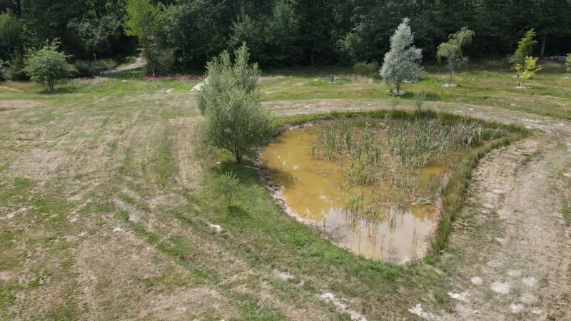
A 3-hectare wooded area less than 2 km from the village of Etrez. It is both a place for walks and picnics for young and old, and a place dedicated to the conservation of tree and shrub species.
Before reaching the site, you will come across the "Children's Hedge", created in 1991 by all the schoolchildren of the municipality, which features 25 different species of trees.
Map and restricted areas
Open in the main mapNearby aerodromes
Open aerodromes within 25 km of the spot, heliports included, with their distance and direction from the spot. Near an aerodrome, drone flying is prohibited or height-limited: check the UAS zones map.
| Aerodrome | Type | Distance | Elevation | Difference |
|---|---|---|---|---|
| Base Hydro-ULM de Montrevel-en-Bresse | Seaplane base | 3.7 km W | 189 m | spot 30 m higher |
| Bourg-Ceyzériat Airport | Aerodrome | 18 km SE | 261 m | spot 42 m lower |
| Hôtel Georges Blanc Heliport | Heliport | 21 km SW | 199 m | spot 20 m higher |
| Crottet-Le Bief ULM | Aerodrome | 24 km W | 182 m | spot 37 m higher |
Aviation weather (METAR and TAF)
No METAR station within 50 km.
Weather and Kp index
Sunrise and sunset
| Day | Dawn | Sunrise | Golden hour | Sunset | Dusk | Day length |
|---|---|---|---|---|---|---|
| Sat 21 Nov | 07:16 | 07:49 | 07:49–08:36 · 16:14–17:01 | 17:01 | 17:34 | 9 h 12 |
| Sun 22 Nov | 07:17 | 07:50 | 07:50–08:38 · 16:13–17:00 | 17:00 | 17:34 | 9 h 10 |
| Mon 23 Nov | 07:18 | 07:52 | 07:52–08:39 · 16:12–17:00 | 17:00 | 17:33 | 9 h 07 |
| Tue 24 Nov | 07:20 | 07:53 | 07:53–08:41 · 16:11–16:59 | 16:59 | 17:32 | 9 h 05 |
| Wed 25 Nov | 07:21 | 07:54 | 07:54–08:42 · 16:10–16:58 | 16:58 | 17:32 | 9 h 03 |
| Thu 26 Nov | 07:22 | 07:56 | 07:56–08:44 · 16:09–16:57 | 16:57 | 17:31 | 9 h 01 |
| Fri 27 Nov | 07:23 | 07:57 | 07:57–08:45 · 16:08–16:57 | 16:57 | 17:30 | 8 h 59 |



Reviews
Log in to review this spot. Log in · Create a free account
No reviews yet. Share yours!