

The Brégnier Cordon dam

No reviews yet
Have you flown here? Share your experience with other pilots.
+ Write the first reviewDescription
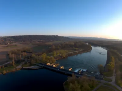
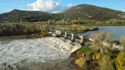
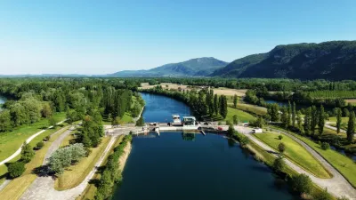
The Brégnier-Cordon hydroelectric power plant, which works together with the Champagneux dam, is part of the development of the same name, begun in 1977 and put into service in 1985 by the Compagnie Nationale du Rhône. Built by the Entreprise Fougerolle, it was completed in 1984.
The plant is located in the municipality of Brégnier-Cordon. It is reached by a small road from the hamlet of Petit Glandieu, which crosses the right arm of the Rhône, i.e. the Brégnier-Cordon diversion canal, joining the îles des Sables. The "open-air" plant is equipped with two bulb units; it is completed by a floating debris outlet on the left bank. The CNR/Oasis database lists four bridges (Compagnie Nationale du Rhône roads): the upstream bridge of the plant, over the headrace canal, carrying the road leading to the plant; the downstream bridge of the plant, over the tailrace canal (a two-span slab bridge, 48 m long and 6.60 m wide, in reinforced concrete); and two single-span bridges over the floating debris outlet (one over the headrace canal and one over the tailrace canal).
Map and restricted areas
Open in the main mapNearby aerodromes
Open aerodromes within 25 km of the spot, heliports included, with their distance and direction from the spot. Near an aerodrome, drone flying is prohibited or height-limited: check the UAS zones map.
| Aerodrome | Type | Distance | Elevation | Difference |
|---|---|---|---|---|
| Belley - Peyrieu Airfield | Aerodrome | 6.8 km N | 225 m | spot 9 m lower |
| Hôtel Le Château Heliport | Heliport | 11 km SW | 387 m | spot 171 m lower |
| St Jean D'avelanne Airfield | Aerodrome | 14 km S | 294 m | spot 77 m lower |
| Morestel Airport | Aerodrome | 17 km W | 245 m | spot 28 m lower |
| Chambéry-Savoie Airport | Airport | 17 km E | 237 m | spot 21 m lower |
Aviation weather (METAR and TAF)
LFLB – Chambéry-Savoie Airport VFR
METAR
METAR LFLB 211100Z AUTO 14003KT 080V200 9999 SCT015 BKN060 12/09 Q1021 NOSIG
- Wind
- 140°, 6 km/h
- Visibility
- 10 km or more
- Clouds
- Scattered (3-4/8) at 1,500 ft (460 m) ; Broken (5-7/8) at 6,000 ft (1830 m)
- Temperature
- 12 °C, dew point 9 °C
- QNH
- 1021 hPa
- Flight category
- VFR: ceiling > 3,000 ft and visibility > 5 mi
TAF
TAF LFLB 210800Z 2109/2209 VRB03KT 9999 SCT050 BECMG 2122/2124 RA BKN050 TEMPO 2203/2209 3000 RA SCT012 BKN020 SCT040TCU BECMG 2205/2207 20010KT
| Period (local time) | Change | Wind | Visibility | Weather | Clouds |
|---|---|---|---|---|---|
| 21/11 10:00 → 21/11 23:00 | Initial conditions | Variable, 6 km/h | 10 km or more | Scattered (3-4/8) at 5,000 ft (1520 m) | |
| 21/11 23:00 → 22/11 06:00 | Becoming | Variable, 6 km/h | 10 km or more | Rain | Broken (5-7/8) at 5,000 ft (1520 m) |
| 22/11 04:00 → 22/11 10:00 | Temporarily | 3.0 km | Rain | Scattered (3-4/8) at 1,200 ft (370 m) ; Broken (5-7/8) at 2,000 ft (610 m) ; Scattered (3-4/8) at 4,000 ft (1220 m) (towering cumulus) | |
| 22/11 06:00 → 22/11 10:00 | Becoming | 200°, 19 km/h | 10 km or more | Rain | Broken (5-7/8) at 5,000 ft (1520 m) |
Weather and Kp index
Sunrise and sunset
| Day | Dawn | Sunrise | Golden hour | Sunset | Dusk | Day length |
|---|---|---|---|---|---|---|
| Sat 21 Nov | 07:12 | 07:45 | 07:45–08:31 · 16:15–17:02 | 17:02 | 17:34 | 9 h 16 |
| Sun 22 Nov | 07:14 | 07:46 | 07:46–08:33 · 16:14–17:01 | 17:01 | 17:33 | 9 h 14 |
| Mon 23 Nov | 07:15 | 07:48 | 07:48–08:34 · 16:13–17:00 | 17:00 | 17:33 | 9 h 12 |
| Tue 24 Nov | 07:16 | 07:49 | 07:49–08:36 · 16:12–16:59 | 16:59 | 17:32 | 9 h 10 |
| Wed 25 Nov | 07:17 | 07:50 | 07:50–08:37 · 16:11–16:59 | 16:59 | 17:32 | 9 h 08 |
| Thu 26 Nov | 07:18 | 07:51 | 07:51–08:39 · 16:11–16:58 | 16:58 | 17:31 | 9 h 06 |
| Fri 27 Nov | 07:19 | 07:53 | 07:53–08:40 · 16:10–16:57 | 16:57 | 17:30 | 9 h 04 |



Reviews
Log in to review this spot. Log in · Create a free account
No reviews yet. Share yours!