

Lac d'Arfeuille
No reviews yet
Have you flown here? Share your experience with other pilots.
+ Write the first reviewDescription
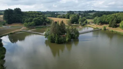
Located north of the town of Saint-Yrieix-la-Perche, Lac d’Arfeuille covers an area of about 15 hectares.
Sports, leisure and relaxation by the water This large body of water close to town lets water sports fans come and cool off windsurfing, canoeing, pedal boating, or simply swimming. On hot summer days, young and old can enjoy the beach and soak up the sun.
Walkers can also enjoy the path that goes around the lake. The more athletic will appreciate the ten or so stations of the fitness trail.
Finally, the shores of Lac d'Arfeuille offer greenery and cool shade for a picnic with family, as a couple or with friends.
Walking trail: from Lac d'Arfeuille to La Rochette A hiking trail starts next to the beach car park. It is a 7km loop (about 2h30 of walking) that goes around the lake and climbs up to the place called La Rochette, where there is a statue of the famous Aréduis, founder of the monastery (see the article on Saint-Yrieix-la-Perche).
To find out the exact route, ask at the Saint-Yrieix-la-Perche tourist office.
Getting to the lake Lac d'Arfeuille is located in the northern part of the town of Saint-Yrieix-la-Perche, near the D704 road towards Nexon. Going further Just on the north side of the lake, the curious can visit the "Village de la Porcelaine"; If you haven't done so yet, the medieval center of Saint-Yrieix-la-Perche is worth discovering.
Map and restricted areas
Open in the main mapNearby aerodromes
Open aerodromes within 25 km of the spot, heliports included, with their distance and direction from the spot. Near an aerodrome, drone flying is prohibited or height-limited: check the UAS zones map.
| Aerodrome | Type | Distance | Elevation | Difference |
|---|---|---|---|---|
| Centre Hospitalier La Perche Heliport | Heliport | 1.1 km S | 359 m | spot 12 m lower |
Aviation weather (METAR and TAF)
LFBL – Limoges Airport LIFR
METAR
METAR LFBL 211100Z AUTO 16008KT 130V190 9999 OVC004 09/09 Q1018 BECMG NSC
- Wind
- 160°, 15 km/h
- Visibility
- 10 km or more
- Clouds
- Overcast (8/8) at 400 ft (120 m)
- Temperature
- 9 °C, dew point 9 °C
- QNH
- 1018 hPa
- Flight category
- LIFR: ceiling < 500 ft or visibility < 1 mi
TAF
TAF LFBL 211100Z 2112/2212 15010KT 9999 OVC004 BECMG 2112/2114 CAVOK TEMPO 2121/2124 4000 -RA BKN030 TEMPO 2200/2206 2000 RA OVC005 FM220600 23010KT 9999 BKN015 TEMPO 2206/2212 26015G30KT 3000 SHRA BKN015TCU PROB30 TEMPO 2206/2212 26020G40KT 1000 TSRA BKN010 BKN015CB
| Period (local time) | Change | Wind | Visibility | Weather | Clouds |
|---|---|---|---|---|---|
| 21/11 13:00 → 22/11 13:00 | Initial conditions | 150°, 19 km/h | 10 km or more | Overcast (8/8) at 400 ft (120 m) | |
| 21/11 13:00 → 22/11 07:00 | Becoming | 150°, 19 km/h | 10 km or more | No significant weather | No significant cloud |
| 21/11 22:00 → 22/11 01:00 | Temporarily | 4.0 km | Rain light | Broken (5-7/8) at 3,000 ft (910 m) | |
| 22/11 01:00 → 22/11 07:00 | Temporarily | 2.0 km | Rain | Overcast (8/8) at 500 ft (150 m) | |
| 22/11 07:00 → 22/11 13:00 | From | 230°, 19 km/h | 10 km or more | Broken (5-7/8) at 1,500 ft (460 m) | |
| 22/11 07:00 → 22/11 13:00 | Temporarily | 260°, 28 km/h, gusts 56 km/h | 3.0 km | Showers of rain | Broken (5-7/8) at 1,500 ft (460 m) (towering cumulus) |
| 22/11 07:00 → 22/11 13:00 | Temporarily, probability 30% | 260°, 37 km/h, gusts 74 km/h | 1,000 m | Thunderstorm rain | Broken (5-7/8) at 1,000 ft (300 m) ; Broken (5-7/8) at 1,500 ft (460 m) (cumulonimbus) |
Weather and Kp index
Sunrise and sunset
| Day | Dawn | Sunrise | Golden hour | Sunset | Dusk | Day length |
|---|---|---|---|---|---|---|
| Sat 21 Nov | 07:30 | 08:02 | 08:02–08:49 · 16:33–17:20 | 17:20 | 17:52 | 9 h 17 |
| Sun 22 Nov | 07:31 | 08:04 | 08:04–08:50 · 16:32–17:19 | 17:19 | 17:52 | 9 h 15 |
| Mon 23 Nov | 07:32 | 08:05 | 08:05–08:52 · 16:31–17:18 | 17:18 | 17:51 | 9 h 13 |
| Tue 24 Nov | 07:34 | 08:06 | 08:06–08:53 · 16:31–17:17 | 17:17 | 17:50 | 9 h 11 |
| Wed 25 Nov | 07:35 | 08:08 | 08:08–08:55 · 16:30–17:17 | 17:17 | 17:50 | 9 h 09 |
| Thu 26 Nov | 07:36 | 08:09 | 08:09–08:56 · 16:29–17:16 | 17:16 | 17:49 | 9 h 07 |
| Fri 27 Nov | 07:37 | 08:10 | 08:10–08:58 · 16:28–17:16 | 17:16 | 17:49 | 9 h 05 |

Reviews
Log in to review this spot. Log in · Create a free account
No reviews yet. Share yours!