

Le Gouffre - Etang Salé - Ile de La Réunion
No reviews yet
Have you flown here? Share your experience with other pilots.
+ Write the first reviewDescription
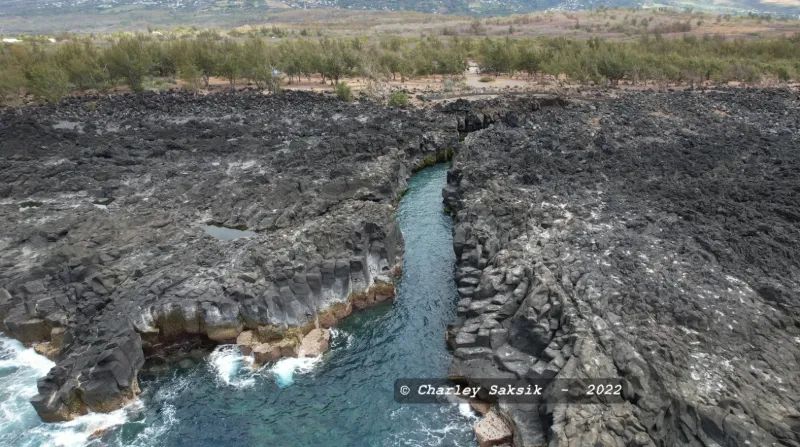
Le Gouffre On the southwest coast of La Réunion, at Etang-Salé, Le Gouffre is a long corridor of volcanic rock where the waves end their run in spectacular fashion. When the sea is rough, the waves crashing in are spectacular. You can walk from the Gouffre both to the south and to the north. This site, known to be very dangerous when the sea is rough, is protected by a barrier that must not be crossed. There are regularly fatal accidents caused by recklessness.
Map and restricted areas
Open in the main mapNearby aerodromes
Open aerodromes within 25 km of the spot, heliports included, with their distance and direction from the spot. Near an aerodrome, drone flying is prohibited or height-limited: check the UAS zones map.
| Aerodrome | Type | Distance | Elevation | Difference |
|---|---|---|---|---|
| Pierrefonds Airport | Airport | 9.7 km SE | 18 m | spot 6 m lower |
Aviation weather (METAR and TAF)
FMEP – Pierrefonds Airport VFR
METAR
METAR FMEP 171330Z AUTO 29008KT 9999 OVC064 28/22 Q1016 NOSIG
- Wind
- 290°, 15 km/h
- Visibility
- 10 km or more
- Clouds
- Overcast (8/8) at 6,400 ft (1950 m)
- Temperature
- 28 °C, dew point 22 °C
- QNH
- 1016 hPa
- Flight category
- VFR: ceiling > 3,000 ft and visibility > 5 mi
TAF
TAF FMEP 171100Z 1712/1721 28012KT 9999 BKN060 BECMG 1712/1714 12008KT BECMG 1715/1717 VRB03KT
| Period (local time) | Change | Wind | Visibility | Weather | Clouds |
|---|---|---|---|---|---|
| 17/11 16:00 → 18/11 01:00 | Initial conditions | 280°, 22 km/h | 10 km or more | Broken (5-7/8) at 6,000 ft (1830 m) | |
| 17/11 16:00 → 17/11 19:00 | Becoming | 120°, 15 km/h | 10 km or more | Broken (5-7/8) at 6,000 ft (1830 m) | |
| 17/11 19:00 → 18/11 01:00 | Becoming | Variable, 6 km/h | 10 km or more | Broken (5-7/8) at 6,000 ft (1830 m) |
Weather and Kp index
Sunrise and sunset
| Day | Dawn | Sunrise | Golden hour | Sunset | Dusk | Day length |
|---|---|---|---|---|---|---|
| Tue 17 Nov | 05:05 | 05:29 | 05:29–06:00 · 18:07–18:38 | 18:38 | 19:02 | 13 h 09 |
| Wed 18 Nov | 05:05 | 05:29 | 05:29–06:00 · 18:08–18:39 | 18:39 | 19:03 | 13 h 10 |
| Thu 19 Nov | 05:04 | 05:28 | 05:28–06:00 · 18:08–18:40 | 18:40 | 19:04 | 13 h 11 |
| Fri 20 Nov | 05:04 | 05:28 | 05:28–06:00 · 18:09–18:40 | 18:40 | 19:04 | 13 h 12 |
| Sat 21 Nov | 05:04 | 05:28 | 05:28–05:59 · 18:09–18:41 | 18:41 | 19:05 | 13 h 12 |
| Sun 22 Nov | 05:04 | 05:28 | 05:28–05:59 · 18:10–18:42 | 18:42 | 19:06 | 13 h 13 |
| Mon 23 Nov | 05:04 | 05:28 | 05:28–05:59 · 18:11–18:42 | 18:42 | 19:06 | 13 h 14 |



Reviews
Log in to review this spot. Log in · Create a free account
No reviews yet. Share yours!