

Fontaine de Vaucluse Castle
No reviews yet
Have you flown here? Share your experience with other pilots.
+ Write the first reviewDescription
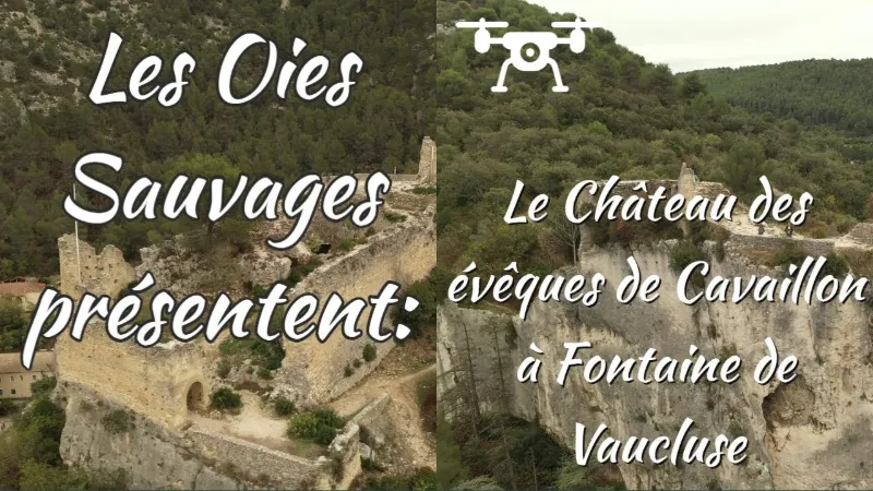
The fortress is said to have been built before the year 1000 by the monks of Saint Victor to protect the tomb of Saint-Veran, an important pilgrimage site. A castrum is mentioned in the deed of donation of 1034. In 1253, the castle is mentioned as the property of the bishop of Cavaillon, lord of the place, who held it as a fief from the count of Toulouse; Bishop Philippe de Cabassole, a friend of Petrarch, often stayed at the castle, which overlooks the Fontaine and the village. The castle became the property of the Sagnet family, Lords of Vaucluse, in the 15th century and was destroyed in the 16th century by the soldiers of the Baron des Adrets. The current castle dates back to the early 13th century: it is a rectangle measuring 49 by 22 meters. A rounded tower reinforces the north-west corner. The wall, preceded by a wide dry moat, is pierced with arrow slits. The entrance was protected by a barbican. An inventory drawn up in 1414 says that it had a chapel, a keep, armories, a guardroom and a cistern.
Map and restricted areas
Open in the main mapNearby aerodromes
Open aerodromes within 25 km of the spot, heliports included, with their distance and direction from the spot. Near an aerodrome, drone flying is prohibited or height-limited: check the UAS zones map.
| Aerodrome | Type | Distance | Elevation | Difference |
|---|---|---|---|---|
| Aérodrome de Carpentras | Aerodrome | 13 km N | 120 m | spot 25 m lower |
| Hôtel La Coquillade Heliport | Heliport | 16 km E | 249 m | spot 154 m lower |
| Centre De Secours Heliport | Heliport | 16 km NW | 87 m | spot 8 m higher |
| Avignon-Caumont Airport | Airport | 18 km W | 38 m | spot 57 m higher |
Aviation weather (METAR and TAF)
LFMV – Avignon-Caumont Airport VFR
METAR
METAR LFMV 210630Z AUTO VRB01KT CAVOK 05/04 Q1020 NOSIG
- Wind
- Variable, 2 km/h
- Visibility
- 10 km or more
- Clouds
- –
- Temperature
- 5 °C, dew point 4 °C
- QNH
- 1020 hPa
- Flight category
- VFR: ceiling > 3,000 ft and visibility > 5 mi
TAF
TAF LFMV 210200Z 2103/2203 VRB03KT CAVOK BECMG 2119/2121 13010KT -RA BKN020 PROB40 TEMPO 2122/2203 13015G25KT 4000 RA BKN012 BKN025
| Period (local time) | Change | Wind | Visibility | Weather | Clouds |
|---|---|---|---|---|---|
| 21/11 04:00 → 21/11 20:00 | Initial conditions | Variable, 6 km/h | 10 km or more | No significant weather | No significant cloud |
| 21/11 20:00 → 22/11 04:00 | Becoming | 130°, 19 km/h | 10 km or more | Rain light | Broken (5-7/8) at 2,000 ft (610 m) |
| 21/11 23:00 → 22/11 04:00 | Temporarily, probability 40% | 130°, 28 km/h, gusts 46 km/h | 4.0 km | Rain | Broken (5-7/8) at 1,200 ft (370 m) ; Broken (5-7/8) at 2,500 ft (760 m) |
Weather and Kp index
Sunrise and sunset
| Day | Dawn | Sunrise | Golden hour | Sunset | Dusk | Day length |
|---|---|---|---|---|---|---|
| Sat 21 Nov | 07:10 | 07:42 | 07:42–08:26 · 16:24–17:09 | 17:09 | 17:40 | 9 h 26 |
| Sun 22 Nov | 07:12 | 07:43 | 07:43–08:28 · 16:23–17:08 | 17:08 | 17:40 | 9 h 24 |
| Mon 23 Nov | 07:13 | 07:44 | 07:44–08:29 · 16:22–17:07 | 17:07 | 17:39 | 9 h 22 |
| Tue 24 Nov | 07:14 | 07:46 | 07:46–08:31 · 16:22–17:07 | 17:07 | 17:38 | 9 h 21 |
| Wed 25 Nov | 07:15 | 07:47 | 07:47–08:32 · 16:21–17:06 | 17:06 | 17:38 | 9 h 19 |
| Thu 26 Nov | 07:16 | 07:48 | 07:48–08:33 · 16:20–17:05 | 17:05 | 17:37 | 9 h 17 |
| Fri 27 Nov | 07:17 | 07:49 | 07:49–08:35 · 16:19–17:05 | 17:05 | 17:37 | 9 h 15 |
Reviews
Log in to review this spot. Log in · Create a free account
No reviews yet. Share yours!