

Mountain
Route FV500
No reviews yet
Have you flown here? Share your experience with other pilots.
+ Write the first reviewDescription
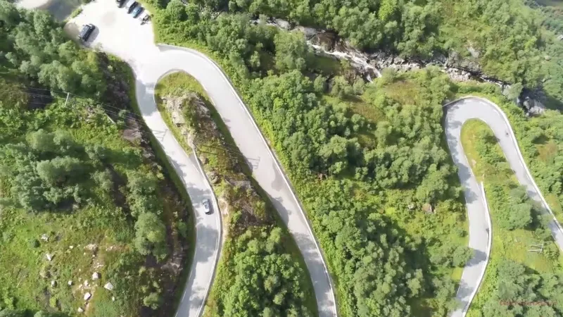
Head to the village of Lysebotn, where the narrow Lysevegen Fv500 road (closed in winter) winds up the east side of the fjord in 27 hairpin bends. That's nearly 900 m of elevation gain in less than 15 km! Once on the plateau, the road crosses a mineral, almost lunar landscape of tundra and granite, between rocky massifs and small mountain lakes, with a few sheep roaming about. There is no other sign of life for kilometers, apart from small piles of votive stones, similar to cairns… Absolutely striking.
Map and restricted areas
Open in the main mapWeather and Kp index
Sunrise and sunset
| Day | Dawn | Sunrise | Golden hour | Sunset | Dusk | Day length |
|---|---|---|---|---|---|---|
| Sat 21 Nov | 07:51 | 08:40 | 08:40–10:00 · 14:38–15:59 | 15:59 | 16:48 | 7 h 19 |
| Sun 22 Nov | 07:53 | 08:42 | 08:42–10:04 · 14:35–15:57 | 15:57 | 16:46 | 7 h 15 |
| Mon 23 Nov | 07:55 | 08:44 | 08:44–10:07 · 14:33–15:55 | 15:55 | 16:45 | 7 h 11 |
| Tue 24 Nov | 07:57 | 08:46 | 08:46–10:10 · 14:30–15:54 | 15:54 | 16:43 | 7 h 07 |
| Wed 25 Nov | 07:59 | 08:48 | 08:48–10:13 · 14:27–15:52 | 15:52 | 16:42 | 7 h 03 |
| Thu 26 Nov | 08:00 | 08:51 | 08:51–10:17 · 14:25–15:51 | 15:51 | 16:41 | 7 h 00 |
| Fri 27 Nov | 08:02 | 08:53 | 08:53–10:20 · 14:22–15:49 | 15:49 | 16:40 | 6 h 56 |
Reviews
Log in to review this spot. Log in · Create a free account
No reviews yet. Share yours!