

Carry le Rouet
No reviews yet
Have you flown here? Share your experience with other pilots.
+ Write the first reviewDescription
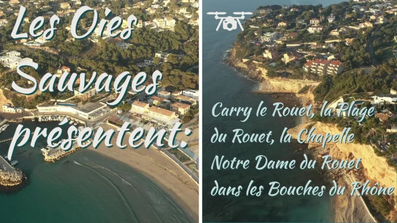
In a natural cove with turquoise colors, this is the largest beach in the town, with a sandy part and a pebble part. It is partially reserved for sun loungers (private beaches). It is also a surf spot in winter.
The Rouet beach is the largest beach in Carry-le-Rouet and therefore the busiest. Fully equipped with showers and restrooms, it has a lifeguard station in summer and is accessible and equipped for people with reduced mobility. It is a sandy beach that's very pleasant for children, who can wade a long way out and enjoy their favorite beach games or take swimming lessons given by lifeguards. A diving center nearby will take you to discover the underwater world of the Côte Bleue, or if you prefer to be out on the water, kayak rentals are available. Restaurants and bars are within easy reach of the beach, and those who like lounging in the sun in comfort can rent mattresses to make the most of their day by the sea. Accessible for disabled visitors Public parking.
Map and restricted areas
Open in the main mapNearby aerodromes
Open aerodromes within 25 km of the spot, heliports included, with their distance and direction from the spot. Near an aerodrome, drone flying is prohibited or height-limited: check the UAS zones map.
| Aerodrome | Type | Distance | Elevation | Difference |
|---|---|---|---|---|
| Marseille Provence Airport | Major airport | 12 km N | 23 m | spot 11 m lower |
| Base Hydro-ULM "Henri Fabre" | Seaplane base | 13 km NW | 0 m | spot 11 m higher |
| Berre/Marignane Seaplane Base | Seaplane base | 13 km N | 2 m | spot 10 m higher |
| Marseille Hydro | Seaplane base | 14 km E | 0 m | spot 11 m higher |
| Centre De Secours Heliport | Heliport | 15 km NW | 41 m | spot 30 m lower |
Aviation weather (METAR and TAF)
LFML – Marseille Provence Airport VFR
METAR
METAR LFML 210630Z AUTO VRB03KT CAVOK 08/06 Q1020 NOSIG
- Wind
- Variable, 6 km/h
- Visibility
- 10 km or more
- Clouds
- –
- Temperature
- 8 °C, dew point 6 °C
- QNH
- 1020 hPa
- Flight category
- VFR: ceiling > 3,000 ft and visibility > 5 mi
TAF
TAF LFML 210200Z 2103/2209 VRB05KT CAVOK TX18/2115Z TN08/2107Z BECMG 2119/2121 11010KT -RA BKN025 PROB40 TEMPO 2121/2209 16015G25KT 4000 RA BKN012 BKN025
| Period (local time) | Change | Wind | Visibility | Weather | Clouds |
|---|---|---|---|---|---|
| 21/11 04:00 → 21/11 20:00 | Initial conditions | Variable, 9 km/h | 10 km or more | No significant cloud | |
| 21/11 20:00 → 22/11 10:00 | Becoming | 110°, 19 km/h | 10 km or more | Rain light | Broken (5-7/8) at 2,500 ft (760 m) |
| 21/11 22:00 → 22/11 10:00 | Temporarily, probability 40% | 160°, 28 km/h, gusts 46 km/h | 4.0 km | Rain | Broken (5-7/8) at 1,200 ft (370 m) ; Broken (5-7/8) at 2,500 ft (760 m) |
Weather and Kp index
Sunrise and sunset
| Day | Dawn | Sunrise | Golden hour | Sunset | Dusk | Day length |
|---|---|---|---|---|---|---|
| Sat 21 Nov | 07:09 | 07:40 | 07:40–08:24 · 16:26–17:10 | 17:10 | 17:41 | 9 h 30 |
| Sun 22 Nov | 07:10 | 07:41 | 07:41–08:25 · 16:25–17:10 | 17:10 | 17:41 | 9 h 28 |
| Mon 23 Nov | 07:11 | 07:42 | 07:42–08:27 · 16:25–17:09 | 17:09 | 17:40 | 9 h 26 |
| Tue 24 Nov | 07:12 | 07:44 | 07:44–08:28 · 16:24–17:08 | 17:08 | 17:40 | 9 h 24 |
| Wed 25 Nov | 07:13 | 07:45 | 07:45–08:29 · 16:23–17:08 | 17:08 | 17:39 | 9 h 22 |
| Thu 26 Nov | 07:15 | 07:46 | 07:46–08:31 · 16:22–17:07 | 17:07 | 17:39 | 9 h 21 |
| Fri 27 Nov | 07:16 | 07:47 | 07:47–08:32 · 16:22–17:07 | 17:07 | 17:38 | 9 h 19 |




Reviews
Log in to review this spot. Log in · Create a free account
No reviews yet. Share yours!