

Punta de Teno

No reviews yet
Have you flown here? Share your experience with other pilots.
+ Write the first reviewDescription
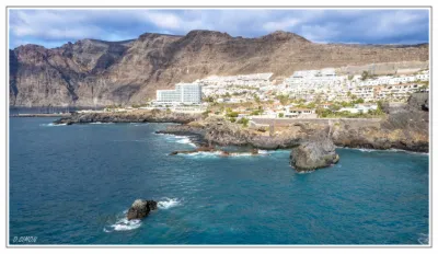
The Punta de Teno drone spot in Tenerife is a magnificent place to fly a drone and capture spectacular footage. Located at the northwestern tip of the island of Tenerife, in Spain, Punta de Teno is a rocky headland with breathtaking scenery.
When you fly your drone over Punta de Teno, you can enjoy an unobstructed view of the Atlantic Ocean and the steep cliffs lining the coast. The crystal-clear waters, unique rock formations and secluded beaches create incredible filming opportunities.
The spot also offers a great variety of landscapes. You can fly over the sheer cliffs and admire the power of the ocean crashing against the rocks. You can also explore the green valleys and steep slopes covered in lush vegetation. Sunsets at Punta de Teno are particularly magical, with warm colors and striking reflections on the water.
It is important to note that Punta de Teno is a protected nature reserve, so the rules in force must be respected. Make sure to check local regulations on drone use and comply with any flight restrictions.
Because of the area's natural beauty and its unspoiled character, Punta de Teno can be popular with photographers, videographers and drone enthusiasts. Be careful not to disturb wildlife and respect the environment during your flight.
In short, the Punta de Teno drone spot in Tenerife is an ideal place to capture spectacular aerial images. With its dramatic cliffs, crystal-clear waters and diverse landscapes, you'll have the chance to create stunning videos and photos. Make the most of this exceptional place to develop your creativity and immortalize the natural beauty of Tenerife.
Map and restricted areas
Open in the main mapAviation weather (METAR and TAF)
GCGM – La Gomera Airport VFR
METAR
METAR GCGM 211030Z 23006KT 9999 FEW020 22/19 Q1023 RMK R09/VRB03KT ARP/23005KT 170V280
- Wind
- 230°, 11 km/h
- Visibility
- 10 km or more
- Clouds
- Few (1-2/8) at 2,000 ft (610 m)
- Temperature
- 22 °C, dew point 19 °C
- QNH
- 1023 hPa
- Flight category
- VFR: ceiling > 3,000 ft and visibility > 5 mi
TAF
TAF AMD GCGM 210918Z 2109/2209 VRB03KT 9999 SCT020 TX23/2115Z TN19/2203Z PROB40 TEMPO 2113/2118 13010KT
| Period (local time) | Change | Wind | Visibility | Weather | Clouds |
|---|---|---|---|---|---|
| 21/11 09:00 → 22/11 09:00 | Initial conditions | Variable, 6 km/h | 10 km or more | Scattered (3-4/8) at 2,000 ft (610 m) | |
| 21/11 13:00 → 21/11 18:00 | Temporarily, probability 40% | 130°, 19 km/h |
Weather and Kp index
Sunrise and sunset
| Day | Dawn | Sunrise | Golden hour | Sunset | Dusk | Day length |
|---|---|---|---|---|---|---|
| Sat 21 Nov | 07:10 | 07:35 | 07:35–08:09 · 17:38–18:13 | 18:13 | 18:38 | 10 h 37 |
| Sun 22 Nov | 07:10 | 07:35 | 07:35–08:10 · 17:38–18:12 | 18:12 | 18:37 | 10 h 36 |
| Mon 23 Nov | 07:11 | 07:36 | 07:36–08:11 · 17:38–18:12 | 18:12 | 18:37 | 10 h 35 |
| Tue 24 Nov | 07:12 | 07:37 | 07:37–08:11 · 17:37–18:12 | 18:12 | 18:37 | 10 h 34 |
| Wed 25 Nov | 07:13 | 07:38 | 07:38–08:12 · 17:37–18:12 | 18:12 | 18:37 | 10 h 33 |
| Thu 26 Nov | 07:13 | 07:39 | 07:39–08:13 · 17:37–18:11 | 18:11 | 18:37 | 10 h 32 |
| Fri 27 Nov | 07:14 | 07:39 | 07:39–08:14 · 17:37–18:11 | 18:11 | 18:37 | 10 h 31 |


Reviews
Log in to review this spot. Log in · Create a free account
No reviews yet. Share yours!