

The Squéouel point

No reviews yet
Have you flown here? Share your experience with other pilots.
+ Write the first reviewDescription
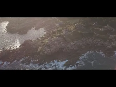
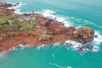
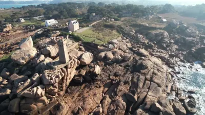
Located in the north of the Côtes-d'Armor department, the Pink Granite Coast has plenty to offer. Over more than 10 kilometers of shoreline, the coast is dotted with chaotic piles of granite blocks with unique shapes and colors. There are only three geological formations like this in the world. One in Corsica, another in China and the last one... in Brittany. If you're looking for a place that is still wild and spared from mass tourism, the Pink Granite Coast will delight you. The Pink Granite Coast is the long stretch of English Channel coastline in the north of Brittany. Over about ten kilometers, from Trébeurden in the west to Perros-Guirec in the east, the Pink Granite Coast is recognizable among a thousand.
Here, granite blocks are everywhere. Of different sizes and shapes, they line the entire shoreline. Sculpted by the sea and wind for millions of years, these blocks have taken on the most improbable shapes. As you stroll along the Pink Granite Coast, you may come across: a hippopotamus, a whale's head, a turtle, a hare, a corkscrew, a stack of crepes or even a painter's palette... Everyone lets their imagination run wild!
Map and restricted areas
Open in the main mapNearby aerodromes
Open aerodromes within 25 km of the spot, heliports included, with their distance and direction from the spot. Near an aerodrome, drone flying is prohibited or height-limited: check the UAS zones map.
| Aerodrome | Type | Distance | Elevation | Difference |
|---|---|---|---|---|
| Lannion-Côte de Granit Airport | Airport | 9.2 km S | 88 m | spot 84 m lower |
| Centre Hospitalier Heliport | Heliport | 13 km S | 28 m | spot 24 m lower |
Aviation weather (METAR and TAF)
LFRO – Lannion-Côte de Granit Airport MVFR
METAR
METAR LFRO 211200Z AUTO 14012KT 9999 OVC012 12/11 Q1013
- Wind
- 140°, 22 km/h
- Visibility
- 10 km or more
- Clouds
- Overcast (8/8) at 1,200 ft (370 m)
- Temperature
- 12 °C, dew point 11 °C
- QNH
- 1013 hPa
- Flight category
- MVFR: ceiling 1,000–3,000 ft or visibility 3–5 mi
TAF
Weather and Kp index
| Day | Weather | Temp. min. / max. | Wind | Rain | Max Kp |
|---|---|---|---|---|---|
| Sat 21 Nov | Partly cloudy | 11° / 13° | 37 km/h SE | 3.6 mm | 2 |
| Sun 22 Nov | Light rain | 11° / 13° | 60 km/h W | 8.1 mm | 2 |
| Mon 23 Nov | Partly cloudy | 11° / 13° | 46 km/h W | 1.2 mm | 4 |
| Tue 24 Nov | Cloudy | 9° / 11° | 31 km/h S | 1.8 mm | 2 |
| Wed 25 Nov | Cloudy | 8° / 9° | 23 km/h SE | 3.0 mm | – |
| Thu 26 Nov | Clear sky | 5° / 9° | 24 km/h E | – | – |
| Fri 27 Nov | Cloudy | 1° / 7° | 26 km/h SE | 2.3 mm | – |
Hour by hour: Saturday 21 November
| Time | Weather | Temp. | Wind | Rain | Clouds | Kp |
|---|---|---|---|---|---|---|
| 13:00 | Partly cloudy | 12° | 25 km/h SE | – | 66 % | 2 |
| 14:00 | Cloudy | 13° | 28 km/h SE | – | 94 % | 2 |
| 15:00 | Partly cloudy | 13° | 31 km/h SE | – | 84 % | 2 |
| 16:00 | Fair | 13° | 31 km/h SE | – | 27 % | 2 |
| 17:00 | Partly cloudy | 12° | 30 km/h SE | – | 43 % | 2 |
| 18:00 | Cloudy | 12° | 35 km/h SE | – | 98 % | 2 |
| 19:00 | Cloudy | 12° | 35 km/h SE | – | 100 % | 2 |
| 20:00 | Light rain | 12° | 35 km/h SE | 0.2 mm | 100 % | 2 |
| 21:00 | Heavy rain | 12° | 36 km/h SE | 1.4 mm | 100 % | 2 |
| 22:00 | Heavy rain | 12° | 37 km/h SE | 2.0 mm | 100 % | 2 |
Hour by hour: Sunday 22 November
| Time | Weather | Temp. | Wind | Rain | Clouds | Kp |
|---|---|---|---|---|---|---|
| 06:00 | Cloudy | 12° | 31 km/h SW | – | 98 % | 2 |
| 07:00 | Light rain | 12° | 36 km/h W | 0.3 mm | 100 % | 2 |
| 08:00 | Rain | 12° | 44 km/h W | 0.7 mm | 100 % | 2 |
| 09:00 | Rain | 12° | 51 km/h W | 1.0 mm | 100 % | 2 |
| 10:00 | Rain | 12° | 59 km/h W | 0.9 mm | 100 % | 2 |
| 11:00 | Heavy rain | 12° | 56 km/h W | 1.0 mm | 100 % | 2 |
| 12:00 | Rain | 12° | 58 km/h W | 0.5 mm | 100 % | 2 |
| 13:00 | Light rain | 12° | 60 km/h W | 0.2 mm | 100 % | 2 |
| 14:00 | Cloudy | 13° | 57 km/h W | – | 100 % | 2 |
| 15:00 | Cloudy | 13° | 59 km/h W | – | 100 % | 2 |
| 16:00 | Light rain | 13° | 59 km/h W | 0.1 mm | 100 % | 2 |
| 17:00 | Cloudy | 13° | 56 km/h W | – | 100 % | 2 |
| 18:00 | Cloudy | 13° | 55 km/h W | – | 100 % | 2 |
| 19:00 | Light rain | 12° | 54 km/h W | 0.2 mm | 99 % | 2 |
| 20:00 | Cloudy | 12° | 52 km/h W | – | 99 % | 2 |
| 21:00 | Cloudy | 12° | 50 km/h W | – | 95 % | 2 |
| 22:00 | Partly cloudy | 12° | 49 km/h W | – | 71 % | 2 |
Sunrise and sunset
| Day | Dawn | Sunrise | Golden hour | Sunset | Dusk | Day length |
|---|---|---|---|---|---|---|
| Sat 21 Nov | 07:57 | 08:32 | 08:32–09:23 · 16:37–17:28 | 17:28 | 18:03 | 8 h 55 |
| Sun 22 Nov | 07:58 | 08:33 | 08:33–09:25 · 16:35–17:27 | 17:27 | 18:02 | 8 h 53 |
| Mon 23 Nov | 08:00 | 08:35 | 08:35–09:26 · 16:34–17:26 | 17:26 | 18:01 | 8 h 50 |
| Tue 24 Nov | 08:01 | 08:36 | 08:36–09:28 · 16:33–17:25 | 17:25 | 18:00 | 8 h 48 |
| Wed 25 Nov | 08:02 | 08:38 | 08:38–09:30 · 16:32–17:24 | 17:24 | 18:00 | 8 h 46 |
| Thu 26 Nov | 08:04 | 08:39 | 08:39–09:31 · 16:31–17:23 | 17:23 | 17:59 | 8 h 44 |
| Fri 27 Nov | 08:05 | 08:41 | 08:41–09:33 · 16:30–17:22 | 17:22 | 17:58 | 8 h 41 |



Reviews
Log in to review this spot. Log in · Create a free account
No reviews yet. Share yours!