

Lac de La Taillat
No reviews yet
Have you flown here? Share your experience with other pilots.
+ Write the first reviewDescription
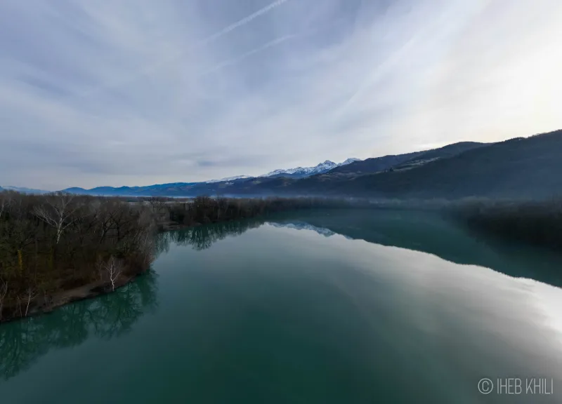
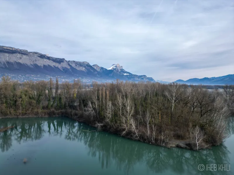
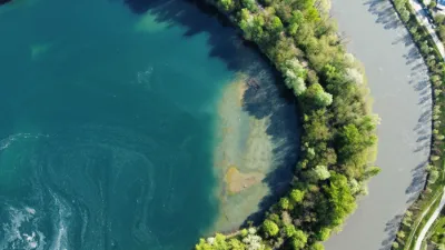
La Boucle de La Taillat is a "natural" area created by humans, and its history is recent. Its biodiversity is only waiting to grow. Once covered by alluvial forest, it was radically transformed by humans in the early 1980s. A former gravel pit for the construction of the motorway, where material extraction continued until 1987, it left behind a large body of water of about 17 hectares on a 40-hectare site. A natural refuge at the gates of the Grenoble area, the site enjoys a preserved environment. La Boucle de La Taillat has been listed in the inventory of Natural Areas of Ecological Interest for Flora and Fauna (ZNIEFF). It was also awarded the Sensitive Natural Area (ENS) label in 2004 by the Isère General Council. The municipality of Meylan, owner of the site, is the project manager for conservation and management actions, with technical and financial support from the Isère General Council. The specific characteristics of La Boucle de La Taillat and its proximity to other prime sites in the Grésivaudan valley give it a particular ecological character. The lake is fed by the water table and is not directly connected to the Isère. The site's location in the Grésivaudan valley corridor allows several bird species to rest and feed during migration periods. Nearly 80 bird species, either nesting or passing through, have been recorded on the site. The green frog, the common toad and the palmate newt use the lake and ponds to breed. About fifteen fish species have been introduced for fishing and contribute to the site's biodiversity. About ten dragonfly species have been recorded, and the site has around 150 plant species.
Map and restricted areas
Open in the main mapNearby aerodromes
Open aerodromes within 25 km of the spot, heliports included, with their distance and direction from the spot. Near an aerodrome, drone flying is prohibited or height-limited: check the UAS zones map.
| Aerodrome | Type | Distance | Elevation | Difference |
|---|---|---|---|---|
| Hôpital Nord Heliport | Heliport | 4.2 km W | 218 m | spot 6 m lower |
| Aérodrome de Grenoble Le Versoud | Aerodrome | 5.2 km NE | 220 m | spot 8 m lower |
| Quartier-Reynies Heliport | Heliport | 13 km SW | 220 m | spot 8 m lower |
| Altiport du Col De Belledonne | Aerodrome | 15 km E | 2,800 m | spot 2,588 m lower |
Aviation weather (METAR and TAF)
LFLS – Grenoble-Isère Airport VFR
METAR
METAR LFLS 210830Z AUTO 08008KT 9999 BKN056 09/08 Q1021 NOSIG
- Wind
- 080°, 15 km/h
- Visibility
- 10 km or more
- Clouds
- Broken (5-7/8) at 5,600 ft (1710 m)
- Temperature
- 9 °C, dew point 8 °C
- QNH
- 1021 hPa
- Flight category
- VFR: ceiling > 3,000 ft and visibility > 5 mi
TAF
TAF LFLS 210200Z 2103/2203 08005KT 9999 BKN055 PROB40 TEMPO 2103/2106 4000 -RA TEMPO 2200/2203 4000 RA
| Period (local time) | Change | Wind | Visibility | Weather | Clouds |
|---|---|---|---|---|---|
| 21/11 04:00 → 22/11 04:00 | Initial conditions | 080°, 9 km/h | 10 km or more | Broken (5-7/8) at 5,500 ft (1680 m) | |
| 21/11 04:00 → 21/11 07:00 | Temporarily, probability 40% | 4.0 km | Rain light | ||
| 22/11 01:00 → 22/11 04:00 | Temporarily | 4.0 km | Rain |
Weather and Kp index
| Day | Weather | Temp. min. / max. | Wind | Rain | Max Kp |
|---|---|---|---|---|---|
| Sat 21 Nov | Fair | 7° / 15° | 6 km/h E | – | 2 |
| Sun 22 Nov | Heavy rain | 7° / 12° | 10 km/h SE | 34 mm | 2 |
| Mon 23 Nov | Rain | 6° / 8° | 7 km/h NW | 7.1 mm | 4 |
| Tue 24 Nov | Cloudy | 3° / 11° | 5 km/h NW | 0.2 mm | 2 |
| Wed 25 Nov | Heavy rain | 5° / 9° | 2 km/h E | 18 mm | – |
| Thu 26 Nov | Partly cloudy | 4° / 8° | 2 km/h N | 2.6 mm | – |
| Fri 27 Nov | Fair | 1° / 9° | 3 km/h E | – | – |
Hour by hour: Saturday 21 November
| Time | Weather | Temp. | Wind | Rain | Clouds | Kp |
|---|---|---|---|---|---|---|
| 09:00 | Partly cloudy | 9° | 3 km/h E | – | 81 % | 2 |
| 10:00 | Partly cloudy | 10° | 3 km/h NE | – | 39 % | 2 |
| 11:00 | Partly cloudy | 12° | 2 km/h NW | – | 39 % | 2 |
| 12:00 | Clear sky | 14° | 3 km/h W | – | 8 % | 2 |
| 13:00 | Fair | 15° | 5 km/h NW | – | 15 % | 1 |
| 14:00 | Fair | 15° | 5 km/h W | – | 22 % | 1 |
| 15:00 | Partly cloudy | 15° | 4 km/h W | – | 48 % | 1 |
| 16:00 | Partly cloudy | 14° | 2 km/h W | – | 42 % | 2 |
| 17:00 | Partly cloudy | 12° | 1 km/h W | – | 88 % | 2 |
| 18:00 | Cloudy | 10° | 2 km/h SW | – | 87 % | 2 |
| 19:00 | Cloudy | 9° | 3 km/h E | – | 95 % | 2 |
| 20:00 | Cloudy | 8° | 4 km/h E | – | 91 % | 2 |
| 21:00 | Partly cloudy | 7° | 5 km/h E | – | 84 % | 2 |
| 22:00 | Cloudy | 7° | 5 km/h SE | – | 99 % | 2 |
Hour by hour: Sunday 22 November
| Time | Weather | Temp. | Wind | Rain | Clouds | Kp |
|---|---|---|---|---|---|---|
| 06:00 | Heavy rain | 10° | 9 km/h SE | 2.1 mm | 100 % | 2 |
| 07:00 | Heavy rain | 10° | 10 km/h SE | 1.6 mm | 100 % | 2 |
| 08:00 | Heavy rain | 11° | 8 km/h S | 3.2 mm | 100 % | 2 |
| 09:00 | Heavy rain | 11° | 8 km/h SE | 3.8 mm | 100 % | 2 |
| 10:00 | Heavy rain | 11° | 7 km/h SE | 3.5 mm | 100 % | 2 |
| 11:00 | Heavy rain | 11° | 7 km/h SE | 1.2 mm | 100 % | 2 |
| 12:00 | Heavy rain | 12° | 6 km/h SE | 1.4 mm | 100 % | 2 |
| 13:00 | Heavy rain | 11° | 7 km/h SE | 1.7 mm | 88 % | 2 |
| 14:00 | Heavy rain | 12° | 9 km/h S | 1.6 mm | 97 % | 2 |
| 15:00 | Heavy rain | 11° | 7 km/h W | 1.6 mm | 98 % | 2 |
| 16:00 | Rain | 11° | 5 km/h S | 0.5 mm | 93 % | 2 |
| 17:00 | Showers | 10° | 4 km/h N | 0.4 mm | 73 % | 2 |
| 18:00 | Showers | 10° | 4 km/h SE | 0.3 mm | 84 % | 2 |
| 19:00 | Rain | 9° | 4 km/h SE | 0.8 mm | 98 % | 2 |
| 20:00 | Showers | 9° | 3 km/h SE | 1.9 mm | 52 % | 2 |
| 21:00 | Heavy rain | 8° | 3 km/h E | 2.2 mm | 97 % | 2 |
| 22:00 | Heavy rain | 8° | 4 km/h SE | 1.4 mm | 100 % | 2 |
Sunrise and sunset
| Day | Dawn | Sunrise | Golden hour | Sunset | Dusk | Day length |
|---|---|---|---|---|---|---|
| Sat 21 Nov | 07:11 | 07:43 | 07:43–08:29 · 16:16–17:02 | 17:02 | 17:35 | 9 h 19 |
| Sun 22 Nov | 07:12 | 07:44 | 07:44–08:30 · 16:15–17:02 | 17:02 | 17:34 | 9 h 17 |
| Mon 23 Nov | 07:13 | 07:46 | 07:46–08:32 · 16:14–17:01 | 17:01 | 17:33 | 9 h 15 |
| Tue 24 Nov | 07:14 | 07:47 | 07:47–08:33 · 16:14–17:00 | 17:00 | 17:33 | 9 h 13 |
| Wed 25 Nov | 07:15 | 07:48 | 07:48–08:35 · 16:13–16:59 | 16:59 | 17:32 | 9 h 11 |
| Thu 26 Nov | 07:17 | 07:49 | 07:49–08:36 · 16:12–16:59 | 16:59 | 17:32 | 9 h 09 |
| Fri 27 Nov | 07:18 | 07:51 | 07:51–08:38 · 16:11–16:58 | 16:58 | 17:31 | 9 h 07 |



Reviews
Log in to review this spot. Log in · Create a free account
No reviews yet. Share yours!