

The Pointe de Kerpenhir

No reviews yet
Have you flown here? Share your experience with other pilots.
+ Write the first reviewDescription
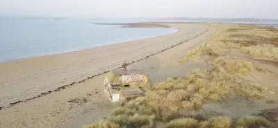
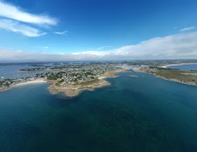
The Pointe de Kerpenhir is a must-see in the Gulf of Morbihan. This headland in Locmariaquer marks the entrance to the Gulf of Morbihan. This breathtaking viewpoint over Port-Navalo is also an ideal place to relax. Here, you can enjoy beautiful beaches and walks. So, off you go for a salty sea-air getaway! Discovering the Pointe de Kerpenhir The entrance to the Gulf of Morbihan From the Pointe de Kerpenhir, you can admire the entrance to the Gulf of Morbihan. It is here, between Arzon and Locmariaquer, that the Petite Mer meets the ocean and vice versa. The view is exceptional, notably with the Port-Navalo lighthouse. Worth discovering in every season!
The statue of Notre-Dame de Kerdro The statue you see at the Pointe de Kerpenhir in Locmariaquer is that of Notre-Dame de Kerdro. This granite statue is 2.70 meters high. The original having been destroyed, this one is relatively recent (1962).
It illustrates the legend of Notre-Dame de Kerdro (which means "safe return" in Breton). It is said that the Virgin appeared at this spot to the sailors of a fishing boat. The Virgin then told them to return to port. And they followed her advice. Shortly after their return, a huge storm began and swept away several ships.
Map and restricted areas
Open in the main mapNearby aerodromes
Open aerodromes within 25 km of the spot, heliports included, with their distance and direction from the spot. Near an aerodrome, drone flying is prohibited or height-limited: check the UAS zones map.
| Aerodrome | Type | Distance | Elevation | Difference |
|---|---|---|---|---|
| Quiberon Airport | Aerodrome | 15 km SW | 11 m | same altitude as the spot |
| Chubert Centre Hospitalier Heliport | Heliport | 18 km NE | 10 m | same altitude as the spot |
| Vannes-Meucon Airport | Airport | 25 km NE | 136 m | spot 127 m lower |
Aviation weather (METAR and TAF)
LFRV – Vannes-Meucon Airport LIFR
METAR
METAR LFRV 210630Z AUTO 10004KT 1000 BR VV/// 11/11 Q1016
- Wind
- 100°, 7 km/h
- Visibility
- 1,000 m
- Weather
- Mist
- Clouds
- –
- Temperature
- 11 °C, dew point 11 °C
- QNH
- 1016 hPa
- Flight category
- LIFR: ceiling < 500 ft or visibility < 1 mi
TAF
Weather and Kp index
| Day | Weather | Temp. min. / max. | Wind | Rain | Max Kp |
|---|---|---|---|---|---|
| Sat 21 Nov | Cloudy | 11° / 14° | 45 km/h SE | 8.2 mm | 2 |
| Sun 22 Nov | Showers | 11° / 14° | 59 km/h W | 9.7 mm | 2 |
| Mon 23 Nov | Partly cloudy | 9° / 14° | 43 km/h W | – | 4 |
| Tue 24 Nov | Clear sky | 7° / 9° | 21 km/h E | – | 2 |
| Wed 25 Nov | Light rain | 6° / 7° | 23 km/h NE | 14 mm | – |
| Thu 26 Nov | Partly cloudy | 2° / 5° | 17 km/h NE | – | – |
| Fri 27 Nov | Light rain | 4° / 13° | 27 km/h SW | 15 mm | – |
Hour by hour: Saturday 21 November
| Time | Weather | Temp. | Wind | Rain | Clouds | Kp |
|---|---|---|---|---|---|---|
| 08:00 | Fog | 11° | 17 km/h SE | – | 98 % | 2 |
| 09:00 | Fog | 11° | 19 km/h SE | – | 100 % | 2 |
| 10:00 | Cloudy | 12° | 23 km/h SE | – | 100 % | 2 |
| 11:00 | Cloudy | 12° | 28 km/h SE | – | 100 % | 2 |
| 12:00 | Cloudy | 13° | 30 km/h SE | – | 98 % | 2 |
| 13:00 | Cloudy | 13° | 31 km/h SE | – | 91 % | 1 |
| 14:00 | Cloudy | 14° | 32 km/h SE | – | 100 % | 1 |
| 15:00 | Cloudy | 14° | 35 km/h SE | – | 99 % | 1 |
| 16:00 | Cloudy | 14° | 37 km/h SE | – | 100 % | 2 |
| 17:00 | Cloudy | 13° | 37 km/h SE | – | 100 % | 2 |
| 18:00 | Rain | 13° | 39 km/h SE | 0.5 mm | 100 % | 2 |
| 19:00 | Heavy rain | 13° | 42 km/h SE | 1.1 mm | 100 % | 2 |
| 20:00 | Heavy rain | 12° | 45 km/h SE | 1.4 mm | 100 % | 2 |
| 21:00 | Heavy rain | 12° | 44 km/h SE | 1.1 mm | 100 % | 2 |
| 22:00 | Rain | 12° | 41 km/h SE | 1.0 mm | 100 % | 2 |
Hour by hour: Sunday 22 November
| Time | Weather | Temp. | Wind | Rain | Clouds | Kp |
|---|---|---|---|---|---|---|
| 06:00 | Light rain | 13° | 46 km/h W | 0.2 mm | 100 % | 2 |
| 07:00 | Cloudy | 12° | 52 km/h W | – | 100 % | 2 |
| 08:00 | Light rain | 12° | 59 km/h W | 0.1 mm | 97 % | 2 |
| 09:00 | Showers | 12° | 54 km/h W | 0.1 mm | 26 % | 2 |
| 10:00 | Fair | 12° | 51 km/h W | – | 19 % | 2 |
| 11:00 | Showers | 13° | 48 km/h W | 0.1 mm | 30 % | 2 |
| 12:00 | Showers | 13° | 49 km/h W | 0.2 mm | 51 % | 2 |
| 13:00 | Showers | 13° | 53 km/h W | 0.2 mm | 33 % | 2 |
| 14:00 | Fair | 13° | 53 km/h W | – | 20 % | 2 |
| 15:00 | Clear sky | 13° | 53 km/h W | – | 6 % | 2 |
| 16:00 | Clear sky | 13° | 54 km/h W | – | 9 % | 2 |
| 17:00 | Clear sky | 12° | 48 km/h W | – | 4 % | 2 |
| 18:00 | Clear sky | 12° | 48 km/h W | – | 9 % | 2 |
| 19:00 | Fair | 12° | 48 km/h W | – | 18 % | 2 |
| 20:00 | Clear sky | 12° | 45 km/h W | – | 5 % | 2 |
| 21:00 | Clear sky | 11° | 44 km/h W | – | 1 % | 2 |
| 22:00 | Clear sky | 11° | 44 km/h W | – | 2 % | 2 |
Sunrise and sunset
| Day | Dawn | Sunrise | Golden hour | Sunset | Dusk | Day length |
|---|---|---|---|---|---|---|
| Sat 21 Nov | 07:51 | 08:25 | 08:25–09:14 · 16:41–17:30 | 17:30 | 18:04 | 9 h 04 |
| Sun 22 Nov | 07:53 | 08:27 | 08:27–09:16 · 16:40–17:29 | 17:29 | 18:03 | 9 h 02 |
| Mon 23 Nov | 07:54 | 08:28 | 08:28–09:18 · 16:39–17:28 | 17:28 | 18:02 | 8 h 59 |
| Tue 24 Nov | 07:55 | 08:30 | 08:30–09:19 · 16:38–17:27 | 17:27 | 18:02 | 8 h 57 |
| Wed 25 Nov | 07:57 | 08:31 | 08:31–09:21 · 16:37–17:26 | 17:26 | 18:01 | 8 h 55 |
| Thu 26 Nov | 07:58 | 08:32 | 08:32–09:22 · 16:36–17:26 | 17:26 | 18:00 | 8 h 53 |
| Fri 27 Nov | 07:59 | 08:34 | 08:34–09:24 · 16:35–17:25 | 17:25 | 18:00 | 8 h 51 |




Reviews
Log in to review this spot. Log in · Create a free account
No reviews yet. Share yours!