

Quiberon peninsula, the Port Blanc arch

No reviews yet
Have you flown here? Share your experience with other pilots.
+ Write the first reviewDescription
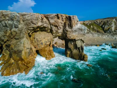
The Port-Blanc Arch, also known as Roche Percée, is a remarkable natural site on the wild coast of Saint-Pierre Quiberon. This spot is the result of marine erosion, which carved an arch into the cliff. Visitors can walk under this arch at low tide.
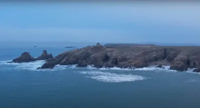
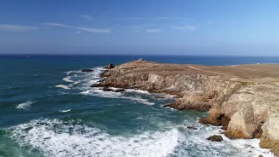
Unfortunately, this spot has been weakened in recent years by successive storms. This has caused the loss of several rocks. No one can say for sure how long this arch will withstand the storms before disappearing, but let's hope it will be as long as possible. The Port-Blanc Arch is a symbol of the power of nature and the beauty of the wild coast of Saint-Pierre Quiberon. It is a must-see for hikers, nature lovers and photographers. We hope future generations will have the chance to discover this wonderful site. Pointe du Percho: From there, you will have a beautiful view of the Wild Coast, the Penthièvre isthmus, its fort and its beach, Belle-Île and the island of Groix. The last stele marks Beg en Aud, the far tip of this coast.
Map and restricted areas
Open in the main mapNearby aerodromes
Open aerodromes within 25 km of the spot, heliports included, with their distance and direction from the spot. Near an aerodrome, drone flying is prohibited or height-limited: check the UAS zones map.
| Aerodrome | Type | Distance | Elevation | Difference |
|---|---|---|---|---|
| Quiberon Airport | Aerodrome | 5.7 km SE | 11 m | spot 5 m higher |
| Le Palais Rescue Center Heliport | Heliport | 20 km S | 27 m | spot 11 m lower |
| Aérodrome de Belle Île | Aerodrome | 22 km S | 52 m | spot 36 m lower |
Aviation weather (METAR and TAF)
LFRH – Lorient South Brittany (Bretagne Sud) Airport LIFR
METAR
METAR LFRH 210630Z AUTO 06006KT 0600 0550 R25/0650N R07/0800N FG VV/// 10/10 Q1016 NOSIG
- Wind
- 060°, 11 km/h
- Visibility
- 600 m
- Weather
- Fog
- Clouds
- –
- Temperature
- 10 °C, dew point 10 °C
- QNH
- 1016 hPa
- Flight category
- LIFR: ceiling < 500 ft or visibility < 1 mi
TAF
TAF LFRH 210500Z 2106/2206 VRB05KT 3000 BR NSC TEMPO 2106/2109 0400 FG VV/// PROB40 TEMPO 2109/2113 0900 FG VV/// TEMPO 2109/2113 11012KT BKN003 BECMG 2113/2115 12015G25KT 9999 NSW BKN016 PROB40 TEMPO 2115/2118 BKN008 TEMPO 2118/2124 3000 RA BKN008 PROB30 TEMPO 2120/2202 BKN003 TEMPO 2200/2206 3000 SHRA BKN008 BKN020CB BECMG 2203/2205 27015G25KT
| Period (local time) | Change | Wind | Visibility | Weather | Clouds |
|---|---|---|---|---|---|
| 21/11 07:00 → 21/11 14:00 | Initial conditions | Variable, 9 km/h | 3.0 km | Mist | No significant cloud |
| 21/11 07:00 → 21/11 10:00 | Temporarily | 400 m | Fog | ||
| 21/11 10:00 → 21/11 14:00 | Temporarily, probability 40% | 900 m | Fog | ||
| 21/11 10:00 → 21/11 14:00 | Temporarily | 110°, 22 km/h | Broken (5-7/8) at 300 ft (90 m) | ||
| 21/11 14:00 → 22/11 04:00 | Becoming | 120°, 28 km/h, gusts 46 km/h | 10 km or more | No significant weather | Broken (5-7/8) at 1,600 ft (490 m) |
| 21/11 16:00 → 21/11 19:00 | Temporarily, probability 40% | Broken (5-7/8) at 800 ft (240 m) | |||
| 21/11 19:00 → 22/11 01:00 | Temporarily | 3.0 km | Rain | Broken (5-7/8) at 800 ft (240 m) | |
| 21/11 21:00 → 22/11 03:00 | Temporarily, probability 30% | Broken (5-7/8) at 300 ft (90 m) | |||
| 22/11 01:00 → 22/11 07:00 | Temporarily | 3.0 km | Showers of rain | Broken (5-7/8) at 800 ft (240 m) ; Broken (5-7/8) at 2,000 ft (610 m) (cumulonimbus) | |
| 22/11 04:00 → 22/11 07:00 | Becoming | 270°, 28 km/h, gusts 46 km/h | 10 km or more | No significant weather | Broken (5-7/8) at 1,600 ft (490 m) |
Weather and Kp index
| Day | Weather | Temp. min. / max. | Wind | Rain | Max Kp |
|---|---|---|---|---|---|
| Sat 21 Nov | Cloudy | 13° / 14° | 45 km/h SE | 7.5 mm | 2 |
| Sun 22 Nov | Showers | 13° / 14° | 64 km/h W | 9.0 mm | 2 |
| Mon 23 Nov | Partly cloudy | 13° / 13° | 48 km/h NW | – | 4 |
| Tue 24 Nov | Fair | 9° / 12° | 33 km/h SE | – | 2 |
| Wed 25 Nov | Light rain | 8° / 9° | 33 km/h E | 16 mm | – |
| Thu 26 Nov | Partly cloudy | 5° / 6° | 27 km/h NE | – | – |
| Fri 27 Nov | Light rain | 9° / 13° | 37 km/h S | 14 mm | – |
Hour by hour: Saturday 21 November
| Time | Weather | Temp. | Wind | Rain | Clouds | Kp |
|---|---|---|---|---|---|---|
| 08:00 | Partly cloudy | 13° | 19 km/h SE | – | 100 % | 2 |
| 09:00 | Cloudy | 13° | 22 km/h SE | – | 100 % | 2 |
| 10:00 | Cloudy | 13° | 25 km/h SE | – | 100 % | 2 |
| 11:00 | Cloudy | 13° | 29 km/h SE | – | 100 % | 2 |
| 12:00 | Cloudy | 13° | 32 km/h SE | – | 95 % | 2 |
| 13:00 | Cloudy | 13° | 34 km/h SE | – | 98 % | 1 |
| 14:00 | Cloudy | 13° | 35 km/h SE | – | 100 % | 1 |
| 15:00 | Partly cloudy | 13° | 38 km/h SE | – | 98 % | 1 |
| 16:00 | Partly cloudy | 13° | 39 km/h SE | – | 100 % | 2 |
| 17:00 | Cloudy | 14° | 40 km/h SE | – | 100 % | 2 |
| 18:00 | Rain | 14° | 41 km/h SE | 0.8 mm | 100 % | 2 |
| 19:00 | Heavy rain | 13° | 42 km/h SE | 1.1 mm | 100 % | 2 |
| 20:00 | Rain | 13° | 45 km/h SE | 0.7 mm | 100 % | 2 |
| 21:00 | Rain | 13° | 44 km/h SE | 0.4 mm | 99 % | 2 |
| 22:00 | Heavy rain | 14° | 40 km/h SE | 2.4 mm | 100 % | 2 |
Hour by hour: Sunday 22 November
| Time | Weather | Temp. | Wind | Rain | Clouds | Kp |
|---|---|---|---|---|---|---|
| 06:00 | Cloudy | 14° | 52 km/h W | – | 100 % | 2 |
| 07:00 | Light rain | 13° | 59 km/h W | 0.3 mm | 100 % | 2 |
| 08:00 | Showers | 13° | 64 km/h W | 0.7 mm | 47 % | 2 |
| 09:00 | Showers | 13° | 54 km/h W | 0.1 mm | 12 % | 2 |
| 10:00 | Showers | 13° | 55 km/h W | 0.2 mm | 29 % | 2 |
| 11:00 | Showers | 13° | 53 km/h W | 0.2 mm | 45 % | 2 |
| 12:00 | Showers | 13° | 52 km/h W | 0.2 mm | 47 % | 2 |
| 13:00 | Showers | 13° | 58 km/h W | 0.3 mm | 8 % | 2 |
| 14:00 | Partly cloudy | 13° | 56 km/h W | – | 40 % | 2 |
| 15:00 | Clear sky | 14° | 55 km/h W | – | 9 % | 2 |
| 16:00 | Fair | 13° | 57 km/h W | – | 26 % | 2 |
| 17:00 | Showers | 13° | 51 km/h W | 0.1 mm | 12 % | 2 |
| 18:00 | Showers | 13° | 51 km/h W | 0.2 mm | 20 % | 2 |
| 19:00 | Showers | 13° | 51 km/h W | 0.2 mm | 40 % | 2 |
| 20:00 | Fair | 13° | 51 km/h W | – | 17 % | 2 |
| 21:00 | Clear sky | 13° | 49 km/h W | – | 11 % | 2 |
| 22:00 | Clear sky | 13° | 47 km/h W | – | 8 % | 2 |
Sunrise and sunset
| Day | Dawn | Sunrise | Golden hour | Sunset | Dusk | Day length |
|---|---|---|---|---|---|---|
| Sat 21 Nov | 07:52 | 08:26 | 08:26–09:15 · 16:42–17:31 | 17:31 | 18:05 | 9 h 04 |
| Sun 22 Nov | 07:53 | 08:28 | 08:28–09:17 · 16:41–17:30 | 17:30 | 18:04 | 9 h 02 |
| Mon 23 Nov | 07:55 | 08:29 | 08:29–09:18 · 16:40–17:29 | 17:29 | 18:03 | 9 h 00 |
| Tue 24 Nov | 07:56 | 08:30 | 08:30–09:20 · 16:39–17:28 | 17:28 | 18:02 | 8 h 57 |
| Wed 25 Nov | 07:57 | 08:32 | 08:32–09:22 · 16:38–17:27 | 17:27 | 18:02 | 8 h 55 |
| Thu 26 Nov | 07:59 | 08:33 | 08:33–09:23 · 16:37–17:27 | 17:27 | 18:01 | 8 h 53 |
| Fri 27 Nov | 08:00 | 08:34 | 08:34–09:25 · 16:36–17:26 | 17:26 | 18:01 | 8 h 51 |


Reviews
Log in to review this spot. Log in · Create a free account
No reviews yet. Share yours!