

Port Anna, Séné

No reviews yet
Have you flown here? Share your experience with other pilots.
+ Write the first reviewDescription
A must-see in Séné, a small commune a few kilometers from Vannes, known for its wild side, its hiking trails, its beaches, its nature reserve, but above all for its charming port: Port Anna
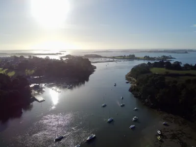
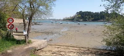
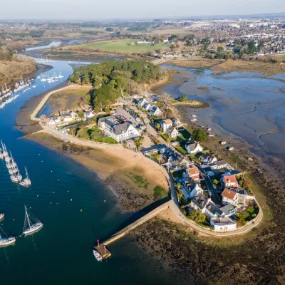
The little port of Port Anna, located at the head of a small cove at the tip of the Séné peninsula, is the last working fishing port in the Gulf of Morbihan. It faces the coast of Arradon and the Conleau peninsula. This geographical position gives it a prime vantage point for watching the boats entering or leaving the port and the Vannes river.
Founded fairly late, in the 18th century, it was once an important fishing port. Today, the fishing boats still based at Port-Anna fish for morgates, glass eels, scallops, shrimp or red mullet, depending on the season, and only one oyster farmer is still present there.
At Port Anna, you can stroll along the quay known as the "quai des morgates", or take the coastal path for superb views over the Conleau channel and see the famous pink house, with its feet in the water, which serves as a landmark for sailors heading up the channel to Vannes.
Map and restricted areas
Open in the main mapNearby aerodromes
Open aerodromes within 25 km of the spot, heliports included, with their distance and direction from the spot. Near an aerodrome, drone flying is prohibited or height-limited: check the UAS zones map.
| Aerodrome | Type | Distance | Elevation | Difference |
|---|---|---|---|---|
| Chubert Centre Hospitalier Heliport | Heliport | 5.3 km NE | 10 m | spot 10 m lower |
| Vannes-Meucon Airport | Airport | 12 km NE | 136 m | spot 136 m lower |
Aviation weather (METAR and TAF)
LFRV – Vannes-Meucon Airport LIFR
METAR
METAR LFRV 210700Z AUTO 09004KT 0600 FG VV/// 10/10 Q1016
- Wind
- 090°, 7 km/h
- Visibility
- 600 m
- Weather
- Fog
- Clouds
- –
- Temperature
- 10 °C, dew point 10 °C
- QNH
- 1016 hPa
- Flight category
- LIFR: ceiling < 500 ft or visibility < 1 mi
TAF
Weather and Kp index
| Day | Weather | Temp. min. / max. | Wind | Rain | Max Kp |
|---|---|---|---|---|---|
| Sat 21 Nov | Cloudy | 10° / 14° | 43 km/h SE | 7.5 mm | 2 |
| Sun 22 Nov | Showers | 11° / 13° | 56 km/h W | 9.8 mm | 2 |
| Mon 23 Nov | Fair | 9° / 14° | 42 km/h W | – | 4 |
| Tue 24 Nov | Clear sky | 6° / 8° | 19 km/h E | – | 2 |
| Wed 25 Nov | Light rain | 6° / 7° | 23 km/h NE | 13 mm | – |
| Thu 26 Nov | Partly cloudy | 2° / 5° | 16 km/h NE | – | – |
| Fri 27 Nov | Light rain | 3° / 13° | 31 km/h SW | 16 mm | – |
Hour by hour: Saturday 21 November
| Time | Weather | Temp. | Wind | Rain | Clouds | Kp |
|---|---|---|---|---|---|---|
| 08:00 | Fog | 10° | 17 km/h E | – | 97 % | 2 |
| 09:00 | Fog | 10° | 18 km/h E | – | 100 % | 2 |
| 10:00 | Cloudy | 11° | 22 km/h SE | – | 100 % | 2 |
| 11:00 | Cloudy | 12° | 27 km/h SE | – | 100 % | 2 |
| 12:00 | Cloudy | 12° | 29 km/h SE | – | 100 % | 2 |
| 13:00 | Cloudy | 13° | 29 km/h SE | – | 91 % | 1 |
| 14:00 | Cloudy | 14° | 31 km/h SE | – | 100 % | 1 |
| 15:00 | Cloudy | 14° | 33 km/h SE | – | 99 % | 1 |
| 16:00 | Cloudy | 13° | 34 km/h SE | – | 100 % | 2 |
| 17:00 | Cloudy | 13° | 34 km/h SE | – | 100 % | 2 |
| 18:00 | Light rain | 13° | 36 km/h SE | 0.4 mm | 100 % | 2 |
| 19:00 | Heavy rain | 13° | 41 km/h SE | 1.0 mm | 100 % | 2 |
| 20:00 | Heavy rain | 12° | 43 km/h SE | 1.3 mm | 100 % | 2 |
| 21:00 | Heavy rain | 12° | 42 km/h SE | 1.2 mm | 100 % | 2 |
| 22:00 | Rain | 12° | 40 km/h SE | 0.9 mm | 100 % | 2 |
Hour by hour: Sunday 22 November
| Time | Weather | Temp. | Wind | Rain | Clouds | Kp |
|---|---|---|---|---|---|---|
| 06:00 | Light rain | 13° | 44 km/h W | 0.1 mm | 100 % | 2 |
| 07:00 | Cloudy | 12° | 50 km/h W | – | 100 % | 2 |
| 08:00 | Cloudy | 12° | 56 km/h W | – | 99 % | 2 |
| 09:00 | Showers | 12° | 54 km/h W | 0.1 mm | 37 % | 2 |
| 10:00 | Fair | 12° | 50 km/h W | – | 19 % | 2 |
| 11:00 | Showers | 13° | 47 km/h W | 0.1 mm | 32 % | 2 |
| 12:00 | Showers | 13° | 47 km/h W | 0.1 mm | 44 % | 2 |
| 13:00 | Showers | 13° | 51 km/h W | 0.2 mm | 31 % | 2 |
| 14:00 | Showers | 13° | 52 km/h W | 0.2 mm | 24 % | 2 |
| 15:00 | Clear sky | 13° | 51 km/h W | – | 9 % | 2 |
| 16:00 | Clear sky | 13° | 52 km/h W | – | 6 % | 2 |
| 17:00 | Clear sky | 12° | 46 km/h W | – | 2 % | 2 |
| 18:00 | Clear sky | 12° | 47 km/h W | – | 11 % | 2 |
| 19:00 | Clear sky | 12° | 46 km/h W | – | 11 % | 2 |
| 20:00 | Clear sky | 11° | 44 km/h W | – | 7 % | 2 |
| 21:00 | Clear sky | 11° | 42 km/h W | – | 2 % | 2 |
| 22:00 | Clear sky | 11° | 42 km/h W | – | 1 % | 2 |
Sunrise and sunset
| Day | Dawn | Sunrise | Golden hour | Sunset | Dusk | Day length |
|---|---|---|---|---|---|---|
| Sat 21 Nov | 07:51 | 08:25 | 08:25–09:14 · 16:40–17:29 | 17:29 | 18:03 | 9 h 03 |
| Sun 22 Nov | 07:52 | 08:26 | 08:26–09:16 · 16:39–17:28 | 17:28 | 18:02 | 9 h 01 |
| Mon 23 Nov | 07:54 | 08:28 | 08:28–09:17 · 16:38–17:27 | 17:27 | 18:01 | 8 h 59 |
| Tue 24 Nov | 07:55 | 08:29 | 08:29–09:19 · 16:37–17:26 | 17:26 | 18:01 | 8 h 57 |
| Wed 25 Nov | 07:56 | 08:31 | 08:31–09:21 · 16:36–17:26 | 17:26 | 18:00 | 8 h 55 |
| Thu 26 Nov | 07:57 | 08:32 | 08:32–09:22 · 16:35–17:25 | 17:25 | 17:59 | 8 h 52 |
| Fri 27 Nov | 07:59 | 08:33 | 08:33–09:24 · 16:34–17:24 | 17:24 | 17:59 | 8 h 50 |



Reviews
Log in to review this spot. Log in · Create a free account
No reviews yet. Share yours!