

Tascon Island
No reviews yet
Have you flown here? Share your experience with other pilots.
+ Write the first reviewDescription
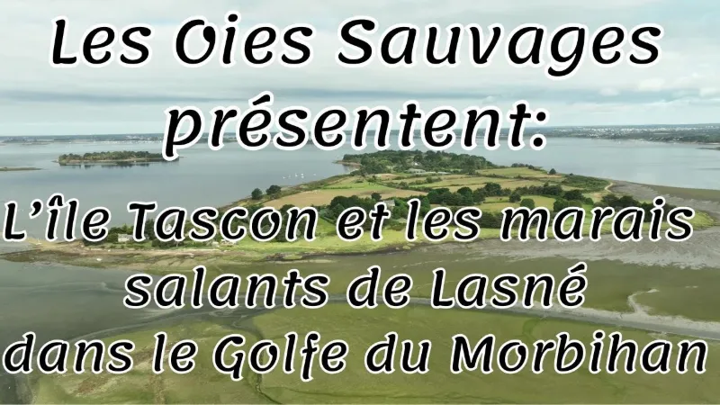
Off the coast of Saint-Armel, Tascon Island promises a nature outing among meadows and rocky foreshore. At low tide, take the submersible causeway and set off to discover the wild landscapes of the Anse de Tascon, surrounded by salt marshes. The largest of the small islands in the Gulf of Morbihan Connected to the commune of Saint-Armel on the Rhuys peninsula, Tascon is the third-largest island in the Gulf of Morbihan by area. At 55 hectares, it is still much smaller than Île aux Moines and Île d'Arz, which cover more than 300 hectares. Tascon remains one of the last islands in the gulf to be farmed. Its meadows are home to fine Charolais cows raised outdoors by a farming couple. An island accessible at low tide Tascon Island is unusual in that it can be reached at low tide by a submersible road that you can take on foot, by bike or by car. The causeway, also called the Passage du Rodu, is 400 meters long. It is uncovered at low tide for a window of 4 to 5 hours depending on the tide. At the junction with it, from the southern tip of the island, a second 200-meter sand causeway opens up and leads to the wild, protected islet of Enézy.
Walking around Tascon Island When you arrive on the island, take the only road on the left on foot. Bordered on one side by the gulf's small sea and on the other by fields and meadows, it runs along the coast for 1.5 km to reach the northern tip of the island. On the way back, you can also walk along the rocky foreshore, but only if you are wearing good shoes!
The farm on Tascon Island Near the hamlet of Tascon is the Le Menach family farm, whose land covers the whole island, which is mostly meadows. Take advantage of your trip to Tascon to visit them and stock up on seasonal vegetables, eggs and Charolais beef straight from the producer.
Tascon, 8 year-round residents! Six families live on Tascon Island year-round, and there are also about twenty second homes. The last farming couple, Christian and Meryem Le Menach, carry on the cattle-raising tradition, now in its fourth generation. They have also repopulated the island with the arrival of their twins Jules and Gabriel! The island now has 8 year-round residents! Together with his brother, Christian owns 24 of the island's 55 hectares, so it is only fitting that he chairs the Tascon residents' association.
The Anse de Tascon, a paradise for birds A true haven of peace for the thousands of birds that live in its cove and its vast seagrass bed (from November to January), the island is also a paradise for birdwatchers! It provides an important feeding site for waterbirds, although the very popular shore fishing on the foreshore remains a source of disturbance. When to cross to Tascon Island? To avoid getting stuck on the island, pay close attention to the tide times. For this, use the times for the Gulf side, not those with Port-Navalo as the reference port. To avoid being caught out by the tide, use the time of low tide at Port du Logeo or the port of Vannes. Then subtract 2 hours from low tide and add up to 2 hours after it. That gives you a 4-hour window, more than enough to walk around the island in peace! The Marais de Lasné, a former salt marsh dating from the Middle Ages, has been classified as a Sensitive Natural Area since 1978, preserving an exceptional natural and cultural heritage. Covering 31 hectares, the site combines environmental protection with traditional activities, hosting two oyster farmers and a salt worker who keep its identity alive. In 2003, a restoration turned the salt marsh into a place for discovery and interpretation, and a refuge for many migratory birds.
Located in Saint-Armel, opposite Tascon Island, the Marais de Lasné resumed activity in 2003 with the arrival of salt worker Olivier Chenelle. In spring, the elegant avocet, the black-winged stilt and the common tern return from Africa to nest. The dikes are freely accessible, offering excellent wildlife viewing, including the shelduck, the common redshank, the egret and many others. Since 2010, the black-headed gull has been nesting on the site, posing a challenge to the survival of the wader broods, as their chicks are prey for this predatory gull. Mediterranean gulls also joined the site in 2014.
Map and restricted areas
Open in the main mapNearby aerodromes
Open aerodromes within 25 km of the spot, heliports included, with their distance and direction from the spot. Near an aerodrome, drone flying is prohibited or height-limited: check the UAS zones map.
| Aerodrome | Type | Distance | Elevation | Difference |
|---|---|---|---|---|
| Chubert Centre Hospitalier Heliport | Heliport | 11 km N | 10 m | spot 5 m lower |
| Vannes-Meucon Airport | Airport | 17 km N | 136 m | spot 131 m lower |
Aviation weather (METAR and TAF)
LFRV – Vannes-Meucon Airport LIFR
METAR
METAR LFRV 210630Z AUTO 10004KT 1000 BR VV/// 11/11 Q1016
- Wind
- 100°, 7 km/h
- Visibility
- 1,000 m
- Weather
- Mist
- Clouds
- –
- Temperature
- 11 °C, dew point 11 °C
- QNH
- 1016 hPa
- Flight category
- LIFR: ceiling < 500 ft or visibility < 1 mi
TAF
Weather and Kp index
| Day | Weather | Temp. min. / max. | Wind | Rain | Max Kp |
|---|---|---|---|---|---|
| Sat 21 Nov | Cloudy | 10° / 14° | 41 km/h SE | 5.7 mm | 2 |
| Sun 22 Nov | Showers | 11° / 13° | 54 km/h W | 10 mm | 2 |
| Mon 23 Nov | Fair | 8° / 13° | 40 km/h W | – | 4 |
| Tue 24 Nov | Clear sky | 6° / 8° | 18 km/h E | – | 2 |
| Wed 25 Nov | Light rain | 5° / 7° | 22 km/h NE | 12 mm | – |
| Thu 26 Nov | Fair | 2° / 5° | 15 km/h NE | – | – |
| Fri 27 Nov | Light rain | 2° / 12° | 33 km/h SW | 17 mm | – |
Hour by hour: Saturday 21 November
| Time | Weather | Temp. | Wind | Rain | Clouds | Kp |
|---|---|---|---|---|---|---|
| 08:00 | Fog | 10° | 16 km/h E | – | 96 % | 2 |
| 09:00 | Fog | 10° | 17 km/h E | – | 100 % | 2 |
| 10:00 | Cloudy | 11° | 20 km/h SE | – | 100 % | 2 |
| 11:00 | Cloudy | 12° | 25 km/h SE | – | 100 % | 2 |
| 12:00 | Cloudy | 12° | 26 km/h SE | – | 98 % | 2 |
| 13:00 | Cloudy | 13° | 27 km/h SE | – | 94 % | 1 |
| 14:00 | Cloudy | 14° | 29 km/h SE | – | 100 % | 1 |
| 15:00 | Cloudy | 14° | 31 km/h SE | – | 99 % | 1 |
| 16:00 | Cloudy | 13° | 31 km/h SE | – | 100 % | 2 |
| 17:00 | Cloudy | 13° | 31 km/h SE | – | 100 % | 2 |
| 18:00 | Light rain | 13° | 34 km/h SE | 0.3 mm | 100 % | 2 |
| 19:00 | Heavy rain | 12° | 38 km/h SE | 1.2 mm | 100 % | 2 |
| 20:00 | Heavy rain | 12° | 41 km/h SE | 1.1 mm | 100 % | 2 |
| 21:00 | Rain | 12° | 41 km/h SE | 1.0 mm | 100 % | 2 |
| 22:00 | Rain | 12° | 40 km/h SE | 0.6 mm | 100 % | 2 |
Hour by hour: Sunday 22 November
| Time | Weather | Temp. | Wind | Rain | Clouds | Kp |
|---|---|---|---|---|---|---|
| 06:00 | Cloudy | 13° | 42 km/h W | – | 100 % | 2 |
| 07:00 | Cloudy | 12° | 49 km/h W | – | 100 % | 2 |
| 08:00 | Cloudy | 12° | 52 km/h W | – | 99 % | 2 |
| 09:00 | Partly cloudy | 12° | 54 km/h W | – | 58 % | 2 |
| 10:00 | Fair | 12° | 49 km/h W | – | 27 % | 2 |
| 11:00 | Showers | 13° | 46 km/h W | 0.2 mm | 27 % | 2 |
| 12:00 | Showers | 13° | 46 km/h W | 0.1 mm | 31 % | 2 |
| 13:00 | Showers | 13° | 49 km/h W | 0.1 mm | 30 % | 2 |
| 14:00 | Showers | 13° | 51 km/h W | 0.6 mm | 37 % | 2 |
| 15:00 | Fair | 13° | 49 km/h W | – | 15 % | 2 |
| 16:00 | Clear sky | 13° | 50 km/h W | – | 11 % | 2 |
| 17:00 | Clear sky | 12° | 45 km/h W | – | 4 % | 2 |
| 18:00 | Fair | 12° | 45 km/h W | – | 16 % | 2 |
| 19:00 | Clear sky | 11° | 43 km/h W | – | 10 % | 2 |
| 20:00 | Clear sky | 11° | 42 km/h W | – | 8 % | 2 |
| 21:00 | Clear sky | 11° | 39 km/h W | – | 2 % | 2 |
| 22:00 | Clear sky | 11° | 41 km/h W | – | 1 % | 2 |
Sunrise and sunset
| Day | Dawn | Sunrise | Golden hour | Sunset | Dusk | Day length |
|---|---|---|---|---|---|---|
| Sat 21 Nov | 07:51 | 08:25 | 08:25–09:14 · 16:40–17:29 | 17:29 | 18:03 | 9 h 04 |
| Sun 22 Nov | 07:52 | 08:26 | 08:26–09:15 · 16:39–17:28 | 17:28 | 18:02 | 9 h 01 |
| Mon 23 Nov | 07:53 | 08:27 | 08:27–09:17 · 16:38–17:27 | 17:27 | 18:01 | 8 h 59 |
| Tue 24 Nov | 07:54 | 08:29 | 08:29–09:18 · 16:37–17:26 | 17:26 | 18:01 | 8 h 57 |
| Wed 25 Nov | 07:56 | 08:30 | 08:30–09:20 · 16:36–17:26 | 17:26 | 18:00 | 8 h 55 |
| Thu 26 Nov | 07:57 | 08:31 | 08:31–09:22 · 16:35–17:25 | 17:25 | 17:59 | 8 h 53 |
| Fri 27 Nov | 07:58 | 08:33 | 08:33–09:23 · 16:34–17:24 | 17:24 | 17:59 | 8 h 51 |





Reviews
Log in to review this spot. Log in · Create a free account
No reviews yet. Share yours!