

Etang du moulin neuf, Malansac

No reviews yet
Have you flown here? Share your experience with other pilots.
+ Write the first reviewDescription
The ideal place to recharge and enjoy great experiences at the Moulin Neuf Aventure leisure center.
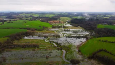
The Moulin Neuf pond is a 14 ha pond located in the commune of Malansac, bordering Pluherlin and Rochefort-en-Terre. This artificial lake was dug in the second half of the 20th century.
Old maps and the 1840 land register show that a natural pond once existed here. It was drained during the 19th century to create new farmland, and was dug out again in the 1970s for tourism reasons.
Before the lake was dug, the current restaurant was home to one of the largest farms in the commune. The pond is owned by Questembert Communauté.
The Moulin Neuf pond is fed by several streams, the most important being the Saint-Gentien stream and the Enfer stream, which join at its western entrance. Its outflow is the Gueuzon (also called the Saint-Gentien stream), a right-bank tributary of the Arz, whose deep valley skirts the hill of Rochefort-en-Terre. The depth of the pond varies between 50 cm and 3 m.
Since 2017, a leisure center called "Moulin Neuf Aventure" has offered many water activities (canoe, pedal boat, kayak, paddleboard...), nature activities (bike rental, pedal kart, rosalie) and thrill activities (zip line, treetop course).
Map and restricted areas
Open in the main mapNearby aerodromes
Open aerodromes within 25 km of the spot, heliports included, with their distance and direction from the spot. Near an aerodrome, drone flying is prohibited or height-limited: check the UAS zones map.
| Aerodrome | Type | Distance | Elevation | Difference |
|---|---|---|---|---|
| Redon Bains-sur-Oust Airport | Aerodrome | 23 km E | 68 m | spot 18 m lower |
Aviation weather (METAR and TAF)
LFRV – Vannes-Meucon Airport LIFR
METAR
METAR LFRV 210700Z AUTO 09004KT 0600 FG VV/// 10/10 Q1016
- Wind
- 090°, 7 km/h
- Visibility
- 600 m
- Weather
- Fog
- Clouds
- –
- Temperature
- 10 °C, dew point 10 °C
- QNH
- 1016 hPa
- Flight category
- LIFR: ceiling < 500 ft or visibility < 1 mi
TAF
Weather and Kp index
Sunrise and sunset
| Day | Dawn | Sunrise | Golden hour | Sunset | Dusk | Day length |
|---|---|---|---|---|---|---|
| Sat 21 Nov | 07:49 | 08:24 | 08:24–09:13 · 16:38–17:27 | 17:27 | 18:01 | 9 h 03 |
| Sun 22 Nov | 07:51 | 08:25 | 08:25–09:14 · 16:37–17:26 | 17:26 | 18:00 | 9 h 01 |
| Mon 23 Nov | 07:52 | 08:26 | 08:26–09:16 · 16:36–17:25 | 17:25 | 18:00 | 8 h 58 |
| Tue 24 Nov | 07:53 | 08:28 | 08:28–09:18 · 16:35–17:24 | 17:24 | 17:59 | 8 h 56 |
| Wed 25 Nov | 07:55 | 08:29 | 08:29–09:19 · 16:34–17:24 | 17:24 | 17:58 | 8 h 54 |
| Thu 26 Nov | 07:56 | 08:30 | 08:30–09:21 · 16:33–17:23 | 17:23 | 17:58 | 8 h 52 |
| Fri 27 Nov | 07:57 | 08:32 | 08:32–09:22 · 16:32–17:22 | 17:22 | 17:57 | 8 h 50 |



Reviews
Log in to review this spot. Log in · Create a free account
No reviews yet. Share yours!