

Châteauneuf-du-Rhône hydroelectric dam

No reviews yet
Have you flown here? Share your experience with other pilots.
+ Write the first reviewDescription
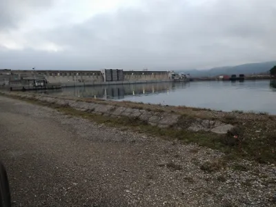
The Henri Poincaré hydroelectric power plant belongs, together with the upstream Rochemaure dam, to the Montélimar drop development, operational in 1958. Built by the Compagnie Nationale du Rhône, the plant was probably completed in 1957 (date inscribed). The downstream bridge was built in 1956. The structure went into service in 1958.
The Henri Poincaré hydroelectric plant is located in the municipality of Châteauneuf-du-Rhône, east of the town. It sits at the outlet of the Montélimar drop diversion canal, which it spans (left arm of the Rhône). It comprises three concrete structures: the power plant itself, equipped with six generating units, an adjoining discharge structure, and a lock on the right bank with a 34 m opening. A reinforced concrete beam bridge crosses these three elements downstream: six spans over a length of 138 m at the plant; two spans over 32.90 m on the discharge structure; three spans over 37 m on the lock. The roadway, a little over 5 m wide, has a 1.45 m sidewalk on the downstream side, edged with a concrete railing. It carries two lanes with two-way traffic, raised on the right bank.
Map and restricted areas
Open in the main mapNearby aerodromes
Open aerodromes within 25 km of the spot, heliports included, with their distance and direction from the spot. Near an aerodrome, drone flying is prohibited or height-limited: check the UAS zones map.
| Aerodrome | Type | Distance | Elevation | Difference |
|---|---|---|---|---|
| Aérodrome de Montélimar - Ancône | Aerodrome | 10 km N | 73 m | spot 6 m lower |
| Aérodrome de Pierrelatte | Aerodrome | 11 km S | 60 m | spot 7 m higher |
| Valréas Visan Airfield | Aerodrome | 24 km SE | 144 m | spot 77 m lower |
Aviation weather (METAR and TAF)
LFMO – Orange-Caritat (BA 115) Air Base VFR
METAR
METAR LFMO 210630Z AUTO 36004KT 320V020 CAVOK 04/04 Q1020 NOSIG
- Wind
- 360°, 7 km/h
- Visibility
- 10 km or more
- Clouds
- –
- Temperature
- 4 °C, dew point 4 °C
- QNH
- 1020 hPa
- Flight category
- VFR: ceiling > 3,000 ft and visibility > 5 mi
TAF
TAF LFMO 210200Z 2103/2203 32003KT CAVOK TX16/2115Z TN05/2105Z PROB30 TEMPO 2122/2203 4000 -RA BECMG 2201/2203 13015G25KT
| Period (local time) | Change | Wind | Visibility | Weather | Clouds |
|---|---|---|---|---|---|
| 21/11 04:00 → 22/11 02:00 | Initial conditions | 320°, 6 km/h | 10 km or more | No significant cloud | |
| 21/11 23:00 → 22/11 04:00 | Temporarily, probability 30% | 4.0 km | Rain light | ||
| 22/11 02:00 → 22/11 04:00 | Becoming | 130°, 28 km/h, gusts 46 km/h | 10 km or more | No significant cloud |
Weather and Kp index
Sunrise and sunset
| Day | Dawn | Sunrise | Golden hour | Sunset | Dusk | Day length |
|---|---|---|---|---|---|---|
| Sat 21 Nov | 07:13 | 07:45 | 07:45–08:30 · 16:24–17:09 | 17:09 | 17:41 | 9 h 23 |
| Sun 22 Nov | 07:15 | 07:47 | 07:47–08:32 · 16:23–17:08 | 17:08 | 17:40 | 9 h 21 |
| Mon 23 Nov | 07:16 | 07:48 | 07:48–08:33 · 16:22–17:07 | 17:07 | 17:39 | 9 h 19 |
| Tue 24 Nov | 07:17 | 07:49 | 07:49–08:35 · 16:21–17:07 | 17:07 | 17:39 | 9 h 17 |
| Wed 25 Nov | 07:18 | 07:50 | 07:50–08:36 · 16:20–17:06 | 17:06 | 17:38 | 9 h 15 |
| Thu 26 Nov | 07:19 | 07:52 | 07:52–08:38 · 16:19–17:05 | 17:05 | 17:38 | 9 h 13 |
| Fri 27 Nov | 07:20 | 07:53 | 07:53–08:39 · 16:19–17:05 | 17:05 | 17:37 | 9 h 12 |



Reviews
Log in to review this spot. Log in · Create a free account
No reviews yet. Share yours!