

Rougiers, the Castrum

No reviews yet
Have you flown here? Share your experience with other pilots.
+ Write the first reviewDescription
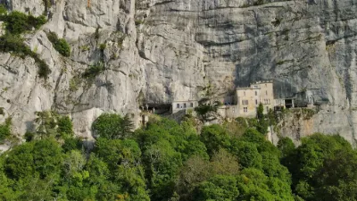
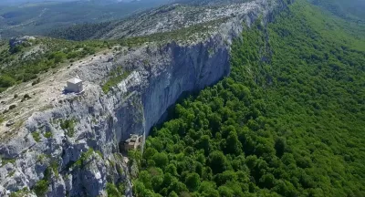
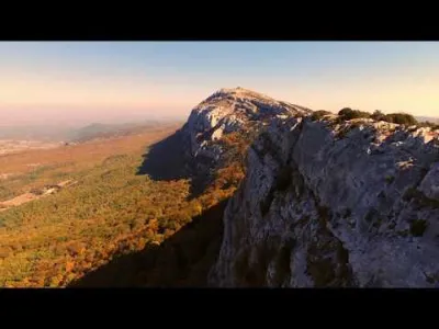
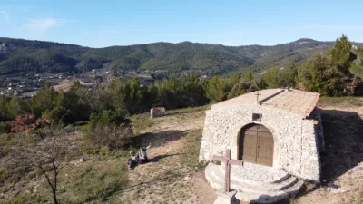
The medieval castrum (12th-15th century) of Saint Jean de Rougiers The castrum of Saint-Jean was built at the end of the 12th century. It is solidly built on a strategic point, surrounded by strong walls punctuated by towers and a keep that is still visible today. It was the property of the lords of Signes. But because of the takeover by the Angevin branch of the Counts of Provence, and the shift of activities toward the towns on the plain, these perched rural castra had few prospects. They were gradually deserted from the end of the 13th century. The site became attractive again, and its population grew between the 1330s and 1345, thanks to the setting up of a glassmakers' workshop. This came with a remodelling of the houses and surrounding courtyards. The following period was more mixed, with times when this fortified settlement regained some interest: - the terrible plague of 1348, which decimated the population of Provence, - the ravages caused by the Routiers of Arnaud de Cervole and then by the Grandes Compagnies, who notably took and devastated Saint-Maximin. - the unrest caused by Raimond de Turenne and his armed bands, who terrorized the region between 1390 and 1410. But the migration toward the plain was too strong and, once calm returned, it resumed, and the site was gradually abandoned. The Chapelle Saint Jean sits on the rocky crown that overlooks the village of Rougiers. Its geographic position, perched on its peak, inevitably exposes it to the whims of the weather. The site consists of a main building that was the place of worship, an annex that may have been used by a hermit, and a cistern for collecting rainwater.
The damage, although it does not affect the foundations, is real and significant. It affects all the elements that keep the building closed in and roofed, as well as all the plaster on the interior walls. At the corner of the outside cistern, the stone wall has partly collapsed. The work involves repointing the four façades, stripping the old render, applying lime plaster to the interior walls and the vault, and restoring the lean-to.
Map and restricted areas
Open in the main mapNearby aerodromes
Open aerodromes within 25 km of the spot, heliports included, with their distance and direction from the spot. Near an aerodrome, drone flying is prohibited or height-limited: check the UAS zones map.
| Aerodrome | Type | Distance | Elevation | Difference |
|---|---|---|---|---|
| Le Castellet Airport | Airport | 13 km S | 424 m | spot 94 m higher |
| Zi Les Paluds Heliport | Heliport | 20 km SW | 116 m | spot 402 m higher |
| Hôpital Jean Marcel Heliport | Heliport | 20 km E | 230 m | spot 288 m higher |
Aviation weather (METAR and TAF)
LFTH – Toulon-Hyères Airport VFR
METAR
METAR LFTH 210630Z AUTO 27005KT 250V310 CAVOK 14/05 Q1018 NOSIG
- Wind
- 270°, 9 km/h
- Visibility
- 10 km or more
- Clouds
- –
- Temperature
- 14 °C, dew point 5 °C
- QNH
- 1018 hPa
- Flight category
- VFR: ceiling > 3,000 ft and visibility > 5 mi
TAF
TAF LFTH 210200Z 2103/2203 30007KT CAVOK BECMG 2119/2122 VRB05KT BKN020 TEMPO 2122/2203 18010KT -RA BKN014 BKN025
| Period (local time) | Change | Wind | Visibility | Weather | Clouds |
|---|---|---|---|---|---|
| 21/11 04:00 → 21/11 20:00 | Initial conditions | 300°, 13 km/h | 10 km or more | No significant weather | No significant cloud |
| 21/11 20:00 → 22/11 04:00 | Becoming | Variable, 9 km/h | 10 km or more | No significant weather | Broken (5-7/8) at 2,000 ft (610 m) |
| 21/11 23:00 → 22/11 04:00 | Temporarily | 180°, 19 km/h | Rain light | Broken (5-7/8) at 1,400 ft (430 m) ; Broken (5-7/8) at 2,500 ft (760 m) |
Weather and Kp index
Sunrise and sunset
| Day | Dawn | Sunrise | Golden hour | Sunset | Dusk | Day length |
|---|---|---|---|---|---|---|
| Sat 21 Nov | 07:06 | 07:38 | 07:38–08:22 · 16:24–17:08 | 17:08 | 17:39 | 9 h 29 |
| Sun 22 Nov | 07:08 | 07:39 | 07:39–08:23 · 16:23–17:07 | 17:07 | 17:38 | 9 h 28 |
| Mon 23 Nov | 07:09 | 07:40 | 07:40–08:24 · 16:22–17:06 | 17:06 | 17:37 | 9 h 26 |
| Tue 24 Nov | 07:10 | 07:41 | 07:41–08:26 · 16:21–17:06 | 17:06 | 17:37 | 9 h 24 |
| Wed 25 Nov | 07:11 | 07:42 | 07:42–08:27 · 16:20–17:05 | 17:05 | 17:36 | 9 h 22 |
| Thu 26 Nov | 07:12 | 07:44 | 07:44–08:28 · 16:20–17:04 | 17:04 | 17:36 | 9 h 20 |
| Fri 27 Nov | 07:13 | 07:45 | 07:45–08:30 · 16:19–17:04 | 17:04 | 17:35 | 9 h 19 |


Reviews
Log in to review this spot. Log in · Create a free account
No reviews yet. Share yours!