

The Château de Portes

No reviews yet
Have you flown here? Share your experience with other pilots.
+ Write the first reviewDescription
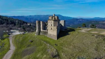
A true gateway to the Hautes Cévennes at the foot of Mont-Lozère, the Château de Portes lies on the edge of the Cévennes National Park, which was inscribed on the UNESCO World Heritage List in June 2011, and has stood for more than 10 centuries of history.
The Château de Portes offers an unrivaled view from 32 meters up over the surrounding valleys, and plenty of opportunities for hiking nearby.
A blend of a medieval fortress and a Renaissance bastion, the château went through many successive phases of construction starting in the 11th century. Around 1700, the building of a spur forming a 42° angle gave the structure a spectacular architecture shaped like a ship's bow, unusual and unique in Europe, which earned it the nickname "Vaisseau des Cévennes" (the Ship of the Cévennes).
Following the intensive exploitation of the coal mines during the war, the ground collapsed, ruining the château, which cracked at its base and was evacuated in 1929.
Around 1960, the voids under the château were filled in, which stabilized it. Its restoration was begun in 1972 by the association "Renaissance du Château de Portes". Every year, dozens of volunteers from all over Europe, lovers of heritage, give their time and passion to restore it.
Map and restricted areas
Open in the main mapNearby aerodromes
Open aerodromes within 25 km of the spot, heliports included, with their distance and direction from the spot. Near an aerodrome, drone flying is prohibited or height-limited: check the UAS zones map.
| Aerodrome | Type | Distance | Elevation | Difference |
|---|---|---|---|---|
| La Grand'combe Airfield | Aerodrome | 3.0 km SW | 502 m | spot 11 m higher |
| Aérodrome d'Alès Cévennes | Airport | 24 km S | 204 m | spot 309 m higher |
Aviation weather (METAR and TAF)
No METAR station within 50 km.
Weather and Kp index
| Day | Weather | Temp. min. / max. | Wind | Rain | Max Kp |
|---|---|---|---|---|---|
| Sat 21 Nov | Fair | 8° / 14° | 8 km/h SE | 1.5 mm | 2 |
| Sun 22 Nov | Showers | 8° / 11° | 37 km/h W | 10 mm | 2 |
| Mon 23 Nov | Partly cloudy | 4° / 12° | 32 km/h NW | – | 4 |
| Tue 24 Nov | Cloudy | 3° / 8° | 9 km/h NW | 17 mm | 2 |
| Wed 25 Nov | Rain | 5° / 7° | 10 km/h N | 72 mm | – |
| Thu 26 Nov | Partly cloudy | 1° / 9° | 5 km/h NW | 0.1 mm | – |
| Fri 27 Nov | Partly cloudy | -0° / 9° | 5 km/h S | 0.1 mm | – |
Hour by hour: Saturday 21 November
| Time | Weather | Temp. | Wind | Rain | Clouds | Kp |
|---|---|---|---|---|---|---|
| 12:00 | Fair | 13° | 7 km/h SE | – | 23 % | 2 |
| 13:00 | Fair | 14° | 8 km/h SE | – | 24 % | 1 |
| 14:00 | Partly cloudy | 13° | 8 km/h SE | – | 70 % | 1 |
| 15:00 | Partly cloudy | 13° | 8 km/h SE | – | 65 % | 1 |
| 16:00 | Partly cloudy | 12° | 8 km/h SE | – | 87 % | 2 |
| 17:00 | Partly cloudy | 10° | 6 km/h SE | – | 84 % | 2 |
| 18:00 | Partly cloudy | 8° | 3 km/h SW | – | 94 % | 2 |
| 19:00 | Cloudy | 8° | 2 km/h NW | – | 98 % | 2 |
| 20:00 | Cloudy | 8° | 3 km/h W | – | 100 % | 2 |
| 21:00 | Cloudy | 9° | 5 km/h SW | – | 100 % | 2 |
| 22:00 | Light rain | 9° | 5 km/h E | 0.2 mm | 100 % | 2 |
Hour by hour: Sunday 22 November
| Time | Weather | Temp. | Wind | Rain | Clouds | Kp |
|---|---|---|---|---|---|---|
| 06:00 | Light rain | 9° | 6 km/h W | 0.2 mm | 100 % | 2 |
| 07:00 | Light rain | 10° | 11 km/h SW | 0.2 mm | 100 % | 2 |
| 08:00 | Cloudy | 10° | 29 km/h W | – | 98 % | 2 |
| 09:00 | Cloudy | 10° | 35 km/h W | – | 99 % | 2 |
| 10:00 | Partly cloudy | 11° | 37 km/h W | – | 72 % | 2 |
| 11:00 | Showers | 11° | 30 km/h W | 0.2 mm | 80 % | 2 |
| 12:00 | Partly cloudy | 11° | 32 km/h W | – | 74 % | 2 |
| 13:00 | Showers | 11° | 33 km/h W | 0.1 mm | 77 % | 2 |
| 14:00 | Showers | 11° | 35 km/h W | 0.2 mm | 70 % | 2 |
| 15:00 | Showers | 11° | 33 km/h W | 0.2 mm | 69 % | 2 |
| 16:00 | Light rain | 10° | 33 km/h W | 0.1 mm | 98 % | 2 |
| 17:00 | Cloudy | 10° | 31 km/h W | – | 88 % | 2 |
| 18:00 | Light rain | 10° | 30 km/h W | 0.2 mm | 98 % | 2 |
| 19:00 | Cloudy | 9° | 31 km/h W | – | 99 % | 2 |
| 20:00 | Cloudy | 9° | 30 km/h W | – | 96 % | 2 |
| 21:00 | Cloudy | 9° | 29 km/h NW | – | 90 % | 2 |
| 22:00 | Cloudy | 9° | 31 km/h NW | – | 92 % | 2 |
Sunrise and sunset
| Day | Dawn | Sunrise | Golden hour | Sunset | Dusk | Day length |
|---|---|---|---|---|---|---|
| Sat 21 Nov | 07:16 | 07:47 | 07:47–08:32 · 16:27–17:12 | 17:12 | 17:44 | 9 h 24 |
| Sun 22 Nov | 07:17 | 07:49 | 07:49–08:34 · 16:26–17:11 | 17:11 | 17:43 | 9 h 22 |
| Mon 23 Nov | 07:18 | 07:50 | 07:50–08:35 · 16:25–17:11 | 17:11 | 17:43 | 9 h 20 |
| Tue 24 Nov | 07:19 | 07:51 | 07:51–08:37 · 16:25–17:10 | 17:10 | 17:42 | 9 h 18 |
| Wed 25 Nov | 07:20 | 07:52 | 07:52–08:38 · 16:24–17:09 | 17:09 | 17:41 | 9 h 17 |
| Thu 26 Nov | 07:21 | 07:54 | 07:54–08:39 · 16:23–17:09 | 17:09 | 17:41 | 9 h 15 |
| Fri 27 Nov | 07:23 | 07:55 | 07:55–08:41 · 16:22–17:08 | 17:08 | 17:40 | 9 h 13 |


Reviews
Log in to review this spot. Log in · Create a free account
No reviews yet. Share yours!