

The Anse des Paulilles, in Port Vendres

No reviews yet
Have you flown here? Share your experience with other pilots.
+ Write the first reviewDescription
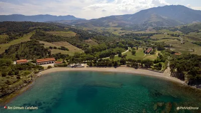
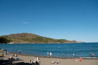
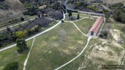
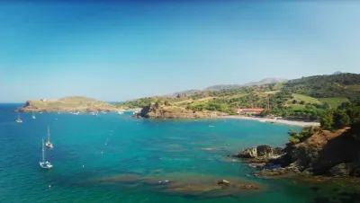
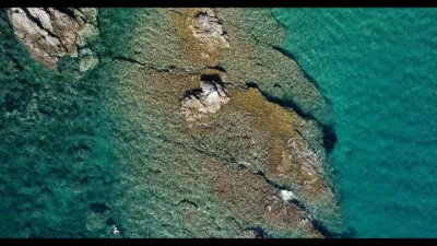
Between the Pyrenees and the Mediterranean, the Anse de Paulilles opens onto three beautiful sandy beaches on the rocky coast of the Pyrénées-Orientales, at the foot of the Albères massif, in the commune of Port-Vendres. A true green setting dominated by the Tour Madeloc, Paulilles lies at the heart of a great landscape made up of the terraced vineyards of the Banyuls – Collioure appellation, oak forests and rocky capes. The red-coloured rocky landscape, which gave the Côte Vermeille its name, is dominated by terraced vineyards. Within this great landscape, the Paulilles estate stands out with its lush vegetation, from which rises a 35-metre-high brick chimney, a reminder of the industrial and working-class history of this protected site. In 2018, Paulilles celebrates 10 years of being open to the public and 20 years since its acquisition by the Conservatoire du littoral.
Map and restricted areas
Open in the main mapNearby aerodromes
Open aerodromes within 25 km of the spot, heliports included, with their distance and direction from the spot. Near an aerodrome, drone flying is prohibited or height-limited: check the UAS zones map.
| Aerodrome | Type | Distance | Elevation | Difference |
|---|---|---|---|---|
| Centre Medical du Cap Peyrefite Heliport | Heliport | 5.5 km SE | 15 m | spot 15 m lower |
| Base ULM Saint Génis | Aerodrome | 19 km W | 46 m | spot 46 m lower |
Aviation weather (METAR and TAF)
LFMP – Perpignan-Rivesaltes (Llabanère) Airport VFR
METAR
METAR LFMP 210700Z AUTO 27002KT CAVOK 09/06 Q1020 BECMG 01010KT
- Wind
- 270°, 4 km/h
- Visibility
- 10 km or more
- Clouds
- –
- Temperature
- 9 °C, dew point 6 °C
- QNH
- 1020 hPa
- Flight category
- VFR: ceiling > 3,000 ft and visibility > 5 mi
TAF
TAF LFMP 210200Z 2103/2203 VRB03KT CAVOK BECMG 2108/2110 01010KT BECMG 2116/2118 VRB03KT
| Period (local time) | Change | Wind | Visibility | Weather | Clouds |
|---|---|---|---|---|---|
| 21/11 04:00 → 21/11 09:00 | Initial conditions | Variable, 6 km/h | 10 km or more | No significant weather | No significant cloud |
| 21/11 09:00 → 21/11 17:00 | Becoming | 010°, 19 km/h | 10 km or more | No significant weather | No significant cloud |
| 21/11 17:00 → 22/11 04:00 | Becoming | Variable, 6 km/h | 10 km or more | No significant weather | No significant cloud |
Weather and Kp index
| Day | Weather | Temp. min. / max. | Wind | Rain | Max Kp |
|---|---|---|---|---|---|
| Sat 21 Nov | Partly cloudy | 14° / 18° | 22 km/h SW | 0.2 mm | 2 |
| Sun 22 Nov | Fair | 12° / 18° | 57 km/h NW | 2.5 mm | 2 |
| Mon 23 Nov | Fair | 12° / 16° | 42 km/h NW | – | 4 |
| Tue 24 Nov | Cloudy | 12° / 14° | 20 km/h S | 0.6 mm | 2 |
| Wed 25 Nov | Rain | 11° / 14° | 24 km/h NW | 15 mm | – |
| Thu 26 Nov | Cloudy | 9° / 12° | 15 km/h N | – | – |
| Fri 27 Nov | Clear sky | 9° / 14° | 11 km/h NW | – | – |
Hour by hour: Saturday 21 November
| Time | Weather | Temp. | Wind | Rain | Clouds | Kp |
|---|---|---|---|---|---|---|
| 08:00 | Cloudy | 14° | 10 km/h SW | – | 100 % | 2 |
| 09:00 | Cloudy | 14° | 11 km/h SW | – | 100 % | 2 |
| 10:00 | Cloudy | 15° | 9 km/h S | – | 94 % | 2 |
| 11:00 | Partly cloudy | 16° | 5 km/h SE | – | 84 % | 2 |
| 12:00 | Partly cloudy | 16° | 5 km/h SE | – | 73 % | 2 |
| 13:00 | Partly cloudy | 17° | 8 km/h SE | – | 69 % | 1 |
| 14:00 | Partly cloudy | 17° | 10 km/h SE | – | 40 % | 1 |
| 15:00 | Partly cloudy | 18° | 11 km/h SE | – | 54 % | 1 |
| 16:00 | Fair | 17° | 15 km/h E | – | 37 % | 2 |
| 17:00 | Partly cloudy | 16° | 12 km/h NE | – | 77 % | 2 |
| 18:00 | Cloudy | 15° | 14 km/h SW | – | 91 % | 2 |
| 19:00 | Light rain | 15° | 17 km/h SW | 0.2 mm | 96 % | 2 |
| 20:00 | Cloudy | 14° | 16 km/h SW | – | 100 % | 2 |
| 21:00 | Cloudy | 14° | 17 km/h SW | – | 100 % | 2 |
| 22:00 | Cloudy | 14° | 20 km/h SW | – | 99 % | 2 |
Hour by hour: Sunday 22 November
| Time | Weather | Temp. | Wind | Rain | Clouds | Kp |
|---|---|---|---|---|---|---|
| 06:00 | Clear sky | 12° | 14 km/h W | – | 9 % | 2 |
| 07:00 | Showers | 13° | 18 km/h NW | 0.3 mm | 7 % | 2 |
| 08:00 | Fair | 13° | 28 km/h NW | – | 27 % | 2 |
| 09:00 | Partly cloudy | 15° | 49 km/h NW | – | 54 % | 2 |
| 10:00 | Cloudy | 16° | 51 km/h NW | – | 94 % | 2 |
| 11:00 | Cloudy | 16° | 49 km/h NW | – | 95 % | 2 |
| 12:00 | Clear sky | 17° | 57 km/h NW | – | 11 % | 2 |
| 13:00 | Fair | 18° | 49 km/h NW | – | 20 % | 2 |
| 14:00 | Clear sky | 18° | 49 km/h NW | – | 12 % | 2 |
| 15:00 | Clear sky | 18° | 50 km/h NW | – | 9 % | 2 |
| 16:00 | Fair | 17° | 50 km/h NW | – | 16 % | 2 |
| 17:00 | Clear sky | 16° | 50 km/h NW | – | 12 % | 2 |
| 18:00 | Partly cloudy | 16° | 48 km/h NW | – | 41 % | 2 |
| 19:00 | Fair | 15° | 42 km/h NW | – | 30 % | 2 |
| 20:00 | Fair | 15° | 46 km/h NW | – | 26 % | 2 |
| 21:00 | Partly cloudy | 15° | 44 km/h NW | – | 63 % | 2 |
| 22:00 | Partly cloudy | 15° | 44 km/h NW | – | 44 % | 2 |
Sunrise and sunset
| Day | Dawn | Sunrise | Golden hour | Sunset | Dusk | Day length |
|---|---|---|---|---|---|---|
| Sat 21 Nov | 07:15 | 07:46 | 07:46–08:29 · 16:38–17:21 | 17:21 | 17:51 | 9 h 34 |
| Sun 22 Nov | 07:16 | 07:47 | 07:47–08:30 · 16:37–17:20 | 17:20 | 17:51 | 9 h 32 |
| Mon 23 Nov | 07:18 | 07:48 | 07:48–08:32 · 16:36–17:19 | 17:19 | 17:50 | 9 h 31 |
| Tue 24 Nov | 07:19 | 07:50 | 07:50–08:33 · 16:35–17:19 | 17:19 | 17:50 | 9 h 29 |
| Wed 25 Nov | 07:20 | 07:51 | 07:51–08:34 · 16:35–17:18 | 17:18 | 17:49 | 9 h 27 |
| Thu 26 Nov | 07:21 | 07:52 | 07:52–08:36 · 16:34–17:18 | 17:18 | 17:49 | 9 h 25 |
| Fri 27 Nov | 07:22 | 07:53 | 07:53–08:37 · 16:33–17:17 | 17:17 | 17:48 | 9 h 24 |

Reviews
Log in to review this spot. Log in · Create a free account
No reviews yet. Share yours!