

The Cap de la Hague, the port of Goury
No reviews yet
Have you flown here? Share your experience with other pilots.
+ Write the first reviewDescription
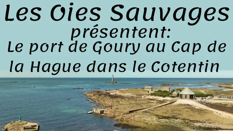
Take a stroll around the Port of Goury Once bustling with intense activity set by the customs officers and the passage of smugglers on the coast of La Hague in Normandy, the port of Goury is today mainly known for its rescue station. Built in 1870 in the commune of Auderville, the rescue station of the Société Nationale de Sauvetage en Mer is clad in stone, which gives the place its charm and makes it solid enough to withstand the powerful waves of the tide. The SNSM is one of the 218 stations along the coast that are essential for watching over potential accidents at sea involving residents and tourists who come to the coast. These stations volunteer to rescue people in danger at sea, and they save lives.
The village port still shelters fishermen today, and you can see their boats along the harbor, which give the place a special charm. So enjoy a walk to get a breath of fresh air in this authentic and wild place in the Manche. Enjoy a peaceful, out-of-the-ordinary moment close to the simple beauty of nature in the heart of a protected area, far from the hustle and bustle of the city. Put on your shoes, head out on an escapade and take the time to explore the secrets of the place: the Cotentin will offer you its finest show.
Map and restricted areas
Open in the main mapNearby aerodromes
Open aerodromes within 25 km of the spot, heliports included, with their distance and direction from the spot. Near an aerodrome, drone flying is prohibited or height-limited: check the UAS zones map.
| Aerodrome | Type | Distance | Elevation | Difference |
|---|---|---|---|---|
| Crossma Heliport | Heliport | 4.3 km SE | 147 m | spot 141 m lower |
| Aérodrome de Vauville | Aerodrome | 13 km SE | 139 m | spot 133 m lower |
| Alderney Airport | Airport | 19 km W | 88 m | spot 82 m lower |
| Flamanville Heliport | Heliport | 21 km S | 82 m | spot 76 m lower |
| Arsenal-Premar Heliport | Heliport | 23 km E | 8 m | same altitude as the spot |
Aviation weather (METAR and TAF)
EGJA – Alderney Airport VFR
METAR
METAR EGJA 210720Z 15008KT 9999 FEW006 SCT027 11/10 Q1016
- Wind
- 150°, 15 km/h
- Visibility
- 10 km or more
- Clouds
- Few (1-2/8) at 600 ft (180 m) ; Scattered (3-4/8) at 2,700 ft (820 m)
- Temperature
- 11 °C, dew point 10 °C
- QNH
- 1016 hPa
- Flight category
- VFR: ceiling > 3,000 ft and visibility > 5 mi
TAF
Weather and Kp index
| Day | Weather | Temp. min. / max. | Wind | Rain | Max Kp |
|---|---|---|---|---|---|
| Sat 21 Nov | Partly cloudy | 8° / 12° | 37 km/h SE | – | 2 |
| Sun 22 Nov | Heavy rain | 10° / 12° | 58 km/h W | 31 mm | 2 |
| Mon 23 Nov | Light rain | 9° / 12° | 31 km/h SE | 8.3 mm | 4 |
| Tue 24 Nov | Fair | 5° / 11° | 30 km/h S | – | 2 |
| Wed 25 Nov | Fair | 5° / 8° | 41 km/h NE | – | – |
| Thu 26 Nov | Cloudy | 6° / 7° | 34 km/h E | – | – |
| Fri 27 Nov | Light rain | 3° / 12° | 33 km/h SE | 2.7 mm | – |
Hour by hour: Saturday 21 November
| Time | Weather | Temp. | Wind | Rain | Clouds | Kp |
|---|---|---|---|---|---|---|
| 08:00 | Fog | 8° | 14 km/h SE | – | 100 % | 2 |
| 09:00 | Fog | 8° | 16 km/h SE | – | 99 % | 2 |
| 10:00 | Fog | 9° | 18 km/h SE | – | 99 % | 2 |
| 11:00 | Fog | 10° | 19 km/h S | – | 100 % | 2 |
| 12:00 | Cloudy | 11° | 21 km/h S | – | 98 % | 2 |
| 13:00 | Partly cloudy | 11° | 20 km/h SE | – | 84 % | 1 |
| 14:00 | Partly cloudy | 11° | 21 km/h SE | – | 80 % | 1 |
| 15:00 | Fair | 11° | 22 km/h SE | – | 34 % | 1 |
| 16:00 | Fair | 12° | 23 km/h SE | – | 38 % | 2 |
| 17:00 | Fair | 11° | 26 km/h SE | – | 20 % | 2 |
| 18:00 | Fair | 11° | 28 km/h SE | – | 32 % | 2 |
| 19:00 | Partly cloudy | 11° | 30 km/h SE | – | 74 % | 2 |
| 20:00 | Cloudy | 10° | 33 km/h SE | – | 99 % | 2 |
| 21:00 | Cloudy | 10° | 35 km/h SE | – | 100 % | 2 |
| 22:00 | Cloudy | 11° | 37 km/h SE | – | 100 % | 2 |
Hour by hour: Sunday 22 November
| Time | Weather | Temp. | Wind | Rain | Clouds | Kp |
|---|---|---|---|---|---|---|
| 06:00 | Heavy rain | 11° | 41 km/h E | 2.3 mm | 100 % | 2 |
| 07:00 | Heavy rain | 11° | 41 km/h E | 1.7 mm | 100 % | 2 |
| 08:00 | Heavy rain | 11° | 41 km/h E | 1.1 mm | 100 % | 2 |
| 09:00 | Rain | 11° | 42 km/h E | 0.9 mm | 100 % | 2 |
| 10:00 | Heavy rain | 10° | 44 km/h E | 2.3 mm | 100 % | 2 |
| 11:00 | Heavy rain | 10° | 41 km/h SE | 1.3 mm | 100 % | 2 |
| 12:00 | Heavy rain | 10° | 37 km/h SE | 1.3 mm | 100 % | 2 |
| 13:00 | Heavy rain | 11° | 33 km/h SE | 1.4 mm | 100 % | 2 |
| 14:00 | Heavy rain | 11° | 36 km/h SE | 1.4 mm | 100 % | 2 |
| 15:00 | Heavy rain | 12° | 58 km/h W | 1.2 mm | 100 % | 2 |
| 16:00 | Rain | 12° | 58 km/h W | 0.9 mm | 100 % | 2 |
| 17:00 | Rain | 12° | 57 km/h NW | 0.8 mm | 100 % | 2 |
| 18:00 | Rain | 12° | 37 km/h NE | 1.0 mm | 100 % | 2 |
| 19:00 | Heavy rain | 11° | 32 km/h NE | 1.2 mm | 100 % | 2 |
| 20:00 | Rain | 12° | 37 km/h NE | 0.9 mm | 100 % | 2 |
| 21:00 | Light rain | 11° | 31 km/h NE | 0.4 mm | 100 % | 2 |
| 22:00 | Rain | 11° | 25 km/h NE | 0.6 mm | 100 % | 2 |
Sunrise and sunset
| Day | Dawn | Sunrise | Golden hour | Sunset | Dusk | Day length |
|---|---|---|---|---|---|---|
| Sat 21 Nov | 07:53 | 08:29 | 08:29–09:21 · 16:26–17:18 | 17:18 | 17:54 | 8 h 49 |
| Sun 22 Nov | 07:55 | 08:31 | 08:31–09:23 · 16:25–17:17 | 17:17 | 17:53 | 8 h 46 |
| Mon 23 Nov | 07:56 | 08:32 | 08:32–09:25 · 16:23–17:16 | 17:16 | 17:52 | 8 h 44 |
| Tue 24 Nov | 07:57 | 08:34 | 08:34–09:27 · 16:22–17:15 | 17:15 | 17:52 | 8 h 41 |
| Wed 25 Nov | 07:59 | 08:35 | 08:35–09:28 · 16:21–17:15 | 17:15 | 17:51 | 8 h 39 |
| Thu 26 Nov | 08:00 | 08:36 | 08:36–09:30 · 16:20–17:14 | 17:14 | 17:50 | 8 h 37 |
| Fri 27 Nov | 08:01 | 08:38 | 08:38–09:32 · 16:19–17:13 | 17:13 | 17:49 | 8 h 35 |





Reviews
Log in to review this spot. Log in · Create a free account
No reviews yet. Share yours!