

Ongles, the Vière site

No reviews yet
Have you flown here? Share your experience with other pilots.
+ Write the first reviewDescription
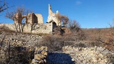
The origins of the Vière site at Ongles go back to protohistoric times. A first village was probably established on its remains in the 12th century. The old Ongles - Vière site reached its peak in the 13th century thanks to the expansion of the town, economic development and the strengthening of the defensive structures. At the end of the 16th-century wars of religion, these were destroyed, probably with explosives, the aim being to make them unusable. The dismantling of the village was a major shock in the history of old Ongles. The inhabited parts, however, were spared. Indeed, the civilian village was beginning to move toward the hamlet of La Fontaine, abandoning the remote position of old Ongles.
In the 17th and 18th centuries, the village was rebuilt with a stronger farming focus. The rubble produced by the demolition of the village provided excellent material for building cultivation terraces (olive grove, plowed fields). The houses then operated as small self-sufficient farms.
However, the 19th century was marked by the definitive abandonment of the settlement.
In the 20th century, the place was abandoned following the First World War and the rural exodus. Since then, the ruin has progressed, along with the encroachment of vegetation.
The municipality of Ongles, with the help of the Fondation du patrimoine, has launched a call for donations to safeguard the Vière site at Ongles, a jewel of local history. https://www.fondation-patrimoine.org/les-projets/site-de-viere-a-ongles
Map and restricted areas
Open in the main mapNearby aerodromes
Open aerodromes within 25 km of the spot, heliports included, with their distance and direction from the spot. Near an aerodrome, drone flying is prohibited or height-limited: check the UAS zones map.
| Aerodrome | Type | Distance | Elevation | Difference |
|---|---|---|---|---|
| Altisurface de Banon | Aerodrome | 9.8 km NW | 1,135 m | spot 469 m lower |
| Aérodrome de Château-Arnoux - Saint-Auban | Aerodrome | 20 km E | 460 m | spot 206 m higher |
| Saint Martin de Castillon | Aerodrome | 25 km SW | 335 m | spot 331 m higher |
Aviation weather (METAR and TAF)
No METAR station within 50 km.
Weather and Kp index
Sunrise and sunset
| Day | Dawn | Sunrise | Golden hour | Sunset | Dusk | Day length |
|---|---|---|---|---|---|---|
| Sat 21 Nov | 07:08 | 07:40 | 07:40–08:24 · 16:21–17:06 | 17:06 | 17:38 | 9 h 26 |
| Sun 22 Nov | 07:09 | 07:41 | 07:41–08:26 · 16:20–17:05 | 17:05 | 17:37 | 9 h 24 |
| Mon 23 Nov | 07:11 | 07:42 | 07:42–08:27 · 16:20–17:05 | 17:05 | 17:36 | 9 h 22 |
| Tue 24 Nov | 07:12 | 07:43 | 07:43–08:29 · 16:19–17:04 | 17:04 | 17:36 | 9 h 20 |
| Wed 25 Nov | 07:13 | 07:45 | 07:45–08:30 · 16:18–17:03 | 17:03 | 17:35 | 9 h 18 |
| Thu 26 Nov | 07:14 | 07:46 | 07:46–08:31 · 16:17–17:03 | 17:03 | 17:35 | 9 h 16 |
| Fri 27 Nov | 07:15 | 07:47 | 07:47–08:33 · 16:17–17:02 | 17:02 | 17:34 | 9 h 15 |




Reviews
Log in to review this spot. Log in · Create a free account
No reviews yet. Share yours!