

The Château d'Artias

No reviews yet
Have you flown here? Share your experience with other pilots.
+ Write the first reviewDescription
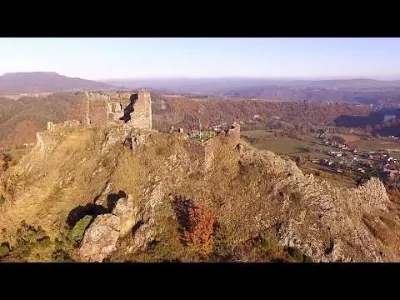
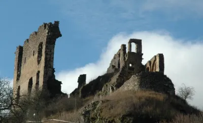
Perched on its rocky spur (723 m) in the municipality of Retournac, the Château d'Artias, in the middle of the Miaune and Madeleine mountains, rises above the meanders of the Loire.
Known since the end of the 10th century, it is one of the oldest castles in the Velay. The Romanesque chapel dates from the 12th century (very beautiful entrance portal)! A visitor center houses many medieval objects found on the site and hosts exhibitions of contemporary objects. Visit the botanical garden and, below it, the bailiff's house and the restored well. New: a bread oven rebuilt in dry stone, a memorial garden, and the preservation of the Chapelle Saint-Denis.. On one of the Way of St. James routes coming from Cluny (via Montarcher), it joins the Via Podiensis by the GR 765.
Map and restricted areas
Open in the main mapNearby aerodromes
Open aerodromes within 25 km of the spot, heliports included, with their distance and direction from the spot. Near an aerodrome, drone flying is prohibited or height-limited: check the UAS zones map.
| Aerodrome | Type | Distance | Elevation | Difference |
|---|---|---|---|---|
| Le Puy-Loudes Airfield | Airport | 24 km SW | 832 m | spot 251 m lower |
Aviation weather (METAR and TAF)
LFMH – Saint-Étienne-Bouthéon Airport VFR
METAR
METAR LFMH 210630Z AUTO 18005KT 9999 SCT046 OVC056 09/06 Q1020
- Wind
- 180°, 9 km/h
- Visibility
- 10 km or more
- Clouds
- Scattered (3-4/8) at 4,600 ft (1400 m) ; Overcast (8/8) at 5,600 ft (1710 m)
- Temperature
- 9 °C, dew point 6 °C
- QNH
- 1020 hPa
- Flight category
- VFR: ceiling > 3,000 ft and visibility > 5 mi
TAF
Weather and Kp index
Sunrise and sunset
| Day | Dawn | Sunrise | Golden hour | Sunset | Dusk | Day length |
|---|---|---|---|---|---|---|
| Sat 21 Nov | 07:18 | 07:50 | 07:50–08:36 · 16:23–17:09 | 17:09 | 17:42 | 9 h 19 |
| Sun 22 Nov | 07:19 | 07:52 | 07:52–08:38 · 16:22–17:09 | 17:09 | 17:41 | 9 h 17 |
| Mon 23 Nov | 07:20 | 07:53 | 07:53–08:39 · 16:22–17:08 | 17:08 | 17:40 | 9 h 15 |
| Tue 24 Nov | 07:22 | 07:54 | 07:54–08:41 · 16:21–17:07 | 17:07 | 17:40 | 9 h 13 |
| Wed 25 Nov | 07:23 | 07:55 | 07:55–08:42 · 16:20–17:07 | 17:07 | 17:39 | 9 h 11 |
| Thu 26 Nov | 07:24 | 07:57 | 07:57–08:43 · 16:19–17:06 | 17:06 | 17:39 | 9 h 09 |
| Fri 27 Nov | 07:25 | 07:58 | 07:58–08:45 · 16:18–17:05 | 17:05 | 17:38 | 9 h 07 |
Reviews
Log in to review this spot. Log in · Create a free account
No reviews yet. Share yours!