

The Lake of St-Pée sur Nivelle

No reviews yet
Have you flown here? Share your experience with other pilots.
+ Write the first reviewDescription
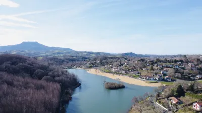
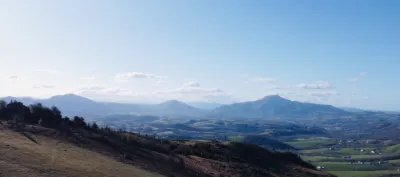
13 km from the sea and 8 km from the Spanish border, at the foot of the mountain in a unique green setting, the Lac de Saint-Pée-sur-Nivelle with its fine sandy beach is a paradise for families. The site offers plenty of activities: an Aquazone leisure center, lots of water slides, pedal boats, canoeing, stand-up paddleboarding, 2 tennis courts, fishing, picnic areas under the trees, children's games... A 3 km walk goes all the way around the lake. Swimming is supervised in July and August.
Map and restricted areas
Open in the main mapNearby aerodromes
Open aerodromes within 25 km of the spot, heliports included, with their distance and direction from the spot. Near an aerodrome, drone flying is prohibited or height-limited: check the UAS zones map.
| Aerodrome | Type | Distance | Elevation | Difference |
|---|---|---|---|---|
| Itxassou Airfield | Aerodrome | 8.0 km E | 185 m | spot 115 m lower |
| Biarritz-Anglet-Bayonne Airport | Airport | 14 km N | 75 m | spot 5 m lower |
| Centre Hospitalier De La Côte Basque Heliport | Heliport | 16 km N | 23 m | spot 47 m higher |
| San Sebastián Airport | Airport | 22 km W | 5 m | spot 65 m higher |
Aviation weather (METAR and TAF)
LFBZ – Biarritz-Anglet-Bayonne Airport VFR
METAR
METAR LFBZ 210630Z AUTO 18004KT 130V230 9999 FEW069 OVC110 15/08 Q1017 NOSIG
- Wind
- 180°, 7 km/h
- Visibility
- 10 km or more
- Clouds
- Few (1-2/8) at 6,900 ft (2100 m) ; Overcast (8/8) at 11,000 ft (3350 m)
- Temperature
- 15 °C, dew point 8 °C
- QNH
- 1017 hPa
- Flight category
- VFR: ceiling > 3,000 ft and visibility > 5 mi
TAF
TAF LFBZ 210500Z 2106/2206 VRB03KT 9999 BKN060 BECMG 2108/2110 18010KT TEMPO 2115/2121 18015G25KT 4000 -RA BKN030 TEMPO 2121/2202 18015G30KT 4000 -RA BKN030 TEMPO 2202/2206 28015G40KT 3000 SHRA BKN015TCU
| Period (local time) | Change | Wind | Visibility | Weather | Clouds |
|---|---|---|---|---|---|
| 21/11 07:00 → 21/11 09:00 | Initial conditions | Variable, 6 km/h | 10 km or more | Broken (5-7/8) at 6,000 ft (1830 m) | |
| 21/11 09:00 → 22/11 07:00 | Becoming | 180°, 19 km/h | 10 km or more | Broken (5-7/8) at 6,000 ft (1830 m) | |
| 21/11 16:00 → 21/11 22:00 | Temporarily | 180°, 28 km/h, gusts 46 km/h | 4.0 km | Rain light | Broken (5-7/8) at 3,000 ft (910 m) |
| 21/11 22:00 → 22/11 03:00 | Temporarily | 180°, 28 km/h, gusts 56 km/h | 4.0 km | Rain light | Broken (5-7/8) at 3,000 ft (910 m) |
| 22/11 03:00 → 22/11 07:00 | Temporarily | 280°, 28 km/h, gusts 74 km/h | 3.0 km | Showers of rain | Broken (5-7/8) at 1,500 ft (460 m) (towering cumulus) |
Weather and Kp index
| Day | Weather | Temp. min. / max. | Wind | Rain | Max Kp |
|---|---|---|---|---|---|
| Sat 21 Nov | Light rain | 13° / 16° | 32 km/h S | 7.5 mm | 2 |
| Sun 22 Nov | Fair | 10° / 15° | 37 km/h W | 10 mm | 2 |
| Mon 23 Nov | Cloudy | 10° / 14° | 24 km/h W | 4.9 mm | 4 |
| Tue 24 Nov | Cloudy | 6° / 15° | 19 km/h S | 0.5 mm | 2 |
| Wed 25 Nov | Showers | 7° / 11° | 18 km/h W | 9.7 mm | – |
| Thu 26 Nov | Showers | 5° / 10° | 16 km/h W | 4.6 mm | – |
| Fri 27 Nov | Cloudy | 7° / 13° | 15 km/h S | – | – |
Hour by hour: Saturday 21 November
| Time | Weather | Temp. | Wind | Rain | Clouds | Kp |
|---|---|---|---|---|---|---|
| 08:00 | Light rain | 14° | 18 km/h S | 0.2 mm | 100 % | 2 |
| 09:00 | Light rain | 14° | 21 km/h S | 0.2 mm | 100 % | 2 |
| 10:00 | Cloudy | 14° | 23 km/h S | – | 100 % | 2 |
| 11:00 | Cloudy | 15° | 25 km/h S | – | 100 % | 2 |
| 12:00 | Cloudy | 15° | 26 km/h S | – | 99 % | 2 |
| 13:00 | Light rain | 16° | 29 km/h S | 0.2 mm | 100 % | 1 |
| 14:00 | Light rain | 15° | 30 km/h S | 0.2 mm | 99 % | 1 |
| 15:00 | Rain | 15° | 32 km/h S | 0.5 mm | 100 % | 1 |
| 16:00 | Rain | 14° | 31 km/h S | 0.6 mm | 100 % | 2 |
| 17:00 | Heavy rain | 14° | 32 km/h S | 1.3 mm | 100 % | 2 |
| 18:00 | Rain | 13° | 32 km/h S | 0.6 mm | 100 % | 2 |
| 19:00 | Rain | 13° | 32 km/h S | 0.5 mm | 100 % | 2 |
| 20:00 | Heavy rain | 13° | 28 km/h S | 2.1 mm | 100 % | 2 |
| 21:00 | Heavy rain | 13° | 24 km/h S | 1.1 mm | 100 % | 2 |
| 22:00 | Cloudy | 14° | 30 km/h S | – | 100 % | 2 |
Hour by hour: Sunday 22 November
| Time | Weather | Temp. | Wind | Rain | Clouds | Kp |
|---|---|---|---|---|---|---|
| 06:00 | Fair | 11° | 31 km/h W | – | 16 % | 2 |
| 07:00 | Fair | 11° | 34 km/h W | – | 15 % | 2 |
| 08:00 | Fair | 12° | 31 km/h W | – | 18 % | 2 |
| 09:00 | Showers | 12° | 29 km/h W | 0.1 mm | 44 % | 2 |
| 10:00 | Partly cloudy | 13° | 32 km/h W | – | 66 % | 2 |
| 11:00 | Partly cloudy | 14° | 28 km/h W | – | 86 % | 2 |
| 12:00 | Fair | 14° | 31 km/h W | – | 36 % | 2 |
| 13:00 | Fair | 15° | 34 km/h W | – | 31 % | 2 |
| 14:00 | Showers | 14° | 37 km/h W | 0.3 mm | 31 % | 2 |
| 15:00 | Showers | 13° | 32 km/h W | 0.2 mm | 64 % | 2 |
| 16:00 | Showers | 13° | 30 km/h W | 0.7 mm | 62 % | 2 |
| 17:00 | Showers | 11° | 26 km/h W | 0.6 mm | 59 % | 2 |
| 18:00 | Showers | 10° | 23 km/h W | 0.6 mm | 36 % | 2 |
| 19:00 | Showers | 10° | 26 km/h W | 0.7 mm | 73 % | 2 |
| 20:00 | Showers | 10° | 24 km/h W | 0.6 mm | 65 % | 2 |
| 21:00 | Showers | 10° | 23 km/h W | 0.5 mm | 75 % | 2 |
| 22:00 | Showers | 10° | 22 km/h W | 0.5 mm | 73 % | 2 |
Sunrise and sunset
| Day | Dawn | Sunrise | Golden hour | Sunset | Dusk | Day length |
|---|---|---|---|---|---|---|
| Sat 21 Nov | 07:36 | 08:07 | 08:07–08:51 · 16:53–17:37 | 17:37 | 18:08 | 9 h 30 |
| Sun 22 Nov | 07:37 | 08:08 | 08:08–08:52 · 16:52–17:36 | 17:36 | 18:07 | 9 h 28 |
| Mon 23 Nov | 07:38 | 08:09 | 08:09–08:54 · 16:51–17:36 | 17:36 | 18:07 | 9 h 26 |
| Tue 24 Nov | 07:39 | 08:11 | 08:11–08:55 · 16:51–17:35 | 17:35 | 18:06 | 9 h 24 |
| Wed 25 Nov | 07:40 | 08:12 | 08:12–08:56 · 16:50–17:34 | 17:34 | 18:06 | 9 h 22 |
| Thu 26 Nov | 07:41 | 08:13 | 08:13–08:58 · 16:49–17:34 | 17:34 | 18:05 | 9 h 20 |
| Fri 27 Nov | 07:43 | 08:14 | 08:14–08:59 · 16:48–17:33 | 17:33 | 18:05 | 9 h 19 |


Reviews
Log in to review this spot. Log in · Create a free account
No reviews yet. Share yours!