

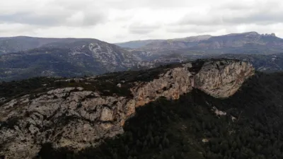
Gémenos, St Clair Chapel

No reviews yet
Have you flown here? Share your experience with other pilots.
+ Write the first reviewDescription
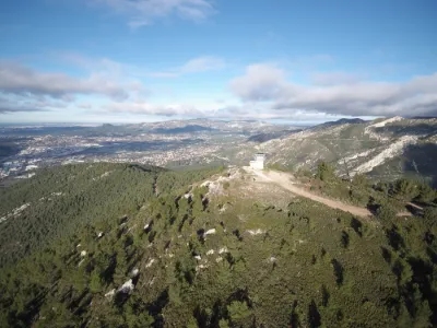
• Ancient and medieval origins: The site first housed a pagan place of worship, then a Gallo-Roman settlement on the Saint-Clair oppidum. It was fortified during the Saracen invasions in the 8th century, with a surrounding wall and a square tower. • Construction: In the 10th century, a Romanesque chapel was built on the base of this old tower. • History: It served as a hermitage in the 17th century before being abandoned in the early 18th century, when its wooden statue of Saint Clair was moved to the Priory of Saint-Jean-de-Garguier. • Pilgrimage: A traditional pilgrimage takes place there every January 2, starting from the Priory of Saint-Jean-de-Garguier, with a Mass and a blessing of the valley
Map and restricted areas
Open in the main mapNearby aerodromes
Open aerodromes within 25 km of the spot, heliports included, with their distance and direction from the spot. Near an aerodrome, drone flying is prohibited or height-limited: check the UAS zones map.
| Aerodrome | Type | Distance | Elevation | Difference |
|---|---|---|---|---|
| Zi Les Paluds Heliport | Heliport | 3.9 km SW | 116 m | spot 323 m higher |
| Le Castellet Airport | Airport | 14 km SE | 424 m | spot 15 m higher |
| Base Hydro-ULM de La Ciotat | Seaplane base | 15 km S | 0 m | spot 439 m higher |
| Hôpital La Timone Heliport | Heliport | 19 km W | 42 m | spot 397 m higher |
| Nord Heliport | Heliport | 23 km W | 187 m | spot 252 m higher |
Aviation weather (METAR and TAF)
LFML – Marseille Provence Airport VFR
METAR
METAR LFML 171330Z AUTO 08005KT 9999 ///TCU 17/13 Q1004 TEMPO 4000 SHRA
- Wind
- 080°, 9 km/h
- Visibility
- 10 km or more
- Clouds
- –
- Temperature
- 17 °C, dew point 13 °C
- QNH
- 1004 hPa
- Flight category
- VFR: ceiling > 3,000 ft and visibility > 5 mi
TAF
TAF AMD LFML 171130Z 1711/1815 VRB06KT 9999 BKN024 TX18/1712Z TN13/1806Z PROB40 TEMPO 1711/1719 4000 SHRA SCT070TCU PROB40 TEMPO 1719/1724 BKN008 PROB30 TEMPO 1800/1807 4000 BR PROB40 TEMPO 1808/1813 SHRA SCT070TCU
| Period (local time) | Change | Wind | Visibility | Weather | Clouds |
|---|---|---|---|---|---|
| 17/11 12:00 → 18/11 16:00 | Initial conditions | Variable, 11 km/h | 10 km or more | Broken (5-7/8) at 2,400 ft (730 m) | |
| 17/11 12:00 → 17/11 20:00 | Temporarily, probability 40% | 4.0 km | Showers of rain | Scattered (3-4/8) at 7,000 ft (2130 m) (towering cumulus) | |
| 17/11 20:00 → 18/11 01:00 | Temporarily, probability 40% | Broken (5-7/8) at 800 ft (240 m) | |||
| 18/11 01:00 → 18/11 08:00 | Temporarily, probability 30% | 4.0 km | Mist | ||
| 18/11 09:00 → 18/11 14:00 | Temporarily, probability 40% | Showers of rain | Scattered (3-4/8) at 7,000 ft (2130 m) (towering cumulus) |
Weather and Kp index
Sunrise and sunset
| Day | Dawn | Sunrise | Golden hour | Sunset | Dusk | Day length |
|---|---|---|---|---|---|---|
| Tue 17 Nov | 07:02 | 07:33 | 07:33–08:16 · 16:28–17:12 | 17:12 | 17:42 | 9 h 38 |
| Wed 18 Nov | 07:04 | 07:34 | 07:34–08:18 · 16:27–17:11 | 17:11 | 17:42 | 9 h 36 |
| Thu 19 Nov | 07:05 | 07:36 | 07:36–08:19 · 16:26–17:10 | 17:10 | 17:41 | 9 h 34 |
| Fri 20 Nov | 07:06 | 07:37 | 07:37–08:21 · 16:25–17:09 | 17:09 | 17:40 | 9 h 32 |
| Sat 21 Nov | 07:07 | 07:38 | 07:38–08:22 · 16:25–17:08 | 17:08 | 17:40 | 9 h 30 |
| Sun 22 Nov | 07:08 | 07:39 | 07:39–08:23 · 16:24–17:08 | 17:08 | 17:39 | 9 h 28 |
| Mon 23 Nov | 07:09 | 07:41 | 07:41–08:25 · 16:23–17:07 | 17:07 | 17:38 | 9 h 26 |

Reviews
Log in to review this spot. Log in · Create a free account
No reviews yet. Share yours!