

Golden Arms: Nocara - Le Armi di Sant'Angelo
Aucun avis pour l'instant
Vous avez volé ici ? Partagez votre expérience avec les autres pilotes.
+ Donner le premier avisDescription
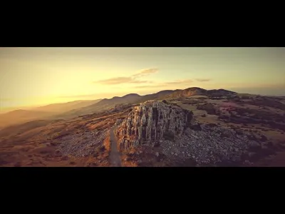
The archaeological site Armi di Sant'Angelo (Arm di Gatt in the local dialect), 4 km from Nocara (CS), is a limestone cliff that stands alone atop the central peak of the Serra Maggiore, at an altitude of 747 m. Like a gothic cathedral, in the past it was used as a mystical place of meeting of the hags of the surrounding municipalities and is linked to mysterious folk beliefs and sinister apparitions of angels that proclaim the death of those who see them.
Near this cliff are the remains of the city of Presinace, a "Civitas" probably Longobard that at the time of Ancient Greece was the site of Serra Maiori, located on a strategic point from which dominates the valley of the Canna river to the Ionian Sea and the valleys of Ragone and Sarmento, tributaries of the Sinni river. In the Hellenistic period, on the Serra Maggiore and the nearby hills, was built a network of fortified settlements placed in defense of territory Italiot the Ionian coast and during the Middle Ages, these places were reoccupied by the people of the plains reproposing the defensive mesh of the Greek age: Presinace, Armi di S. Angelo, Nocara, Murge di Santa Caterina e Monte Soprano, Monte Coppolo, and Bufaleria, were developed by paths that developed along the ridges of the hills. The Legend attributes to Nocara the birthplace of the Greek city of Lagaria. Pliny the Elder wrote: "Where the bay is shaped like a sickle is the site of the ancient city of Lagaria"
Carte et zones de restriction
Voir sur la grande carteMétéo et indice Kp
Lever et coucher du soleil
| Jour | Aube | Lever | Heure dorée | Coucher | Crépuscule | Durée du jour |
|---|---|---|---|---|---|---|
| Mar. 17 nov. | 06:13 | 06:42 | 06:42–07:22 · 15:56–16:36 | 16:36 | 17:05 | 9 h 54 |
| Mer. 18 nov. | 06:14 | 06:43 | 06:43–07:23 · 15:55–16:36 | 16:36 | 17:05 | 9 h 52 |
| Jeu. 19 nov. | 06:15 | 06:44 | 06:44–07:25 · 15:54–16:35 | 16:35 | 17:04 | 9 h 51 |
| Ven. 20 nov. | 06:16 | 06:45 | 06:45–07:26 · 15:53–16:34 | 16:34 | 17:04 | 9 h 49 |
| Sam. 21 nov. | 06:17 | 06:46 | 06:46–07:27 · 15:53–16:34 | 16:34 | 17:03 | 9 h 47 |
| Dim. 22 nov. | 06:18 | 06:47 | 06:47–07:28 · 15:52–16:33 | 16:33 | 17:02 | 9 h 45 |
| Lun. 23 nov. | 06:19 | 06:48 | 06:48–07:30 · 15:51–16:32 | 16:32 | 17:02 | 9 h 44 |
Avis
Connectez-vous pour donner votre avis sur ce spot. Se connecter · Créer un compte gratuit
Aucun avis pour l'instant. Partagez le vôtre !