

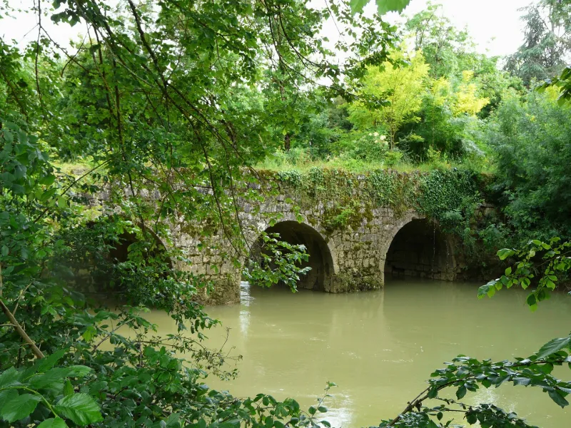
Tauziète Bridge over the Osse
No reviews yet
Have you flown here? Share your experience with other pilots.
+ Write the first reviewHistory
La tradition attribue le pont à l'époque romane. L'ouvrage franchit la rivière grâce à quatre arches plein cintre reposant sur trois piles. Les becs sont établis sur des contreforts sur lesquels étaient sans doute aménagés des refuges. Si le bec de la pile centrale fait face au courant, les becs des piles latérales sont disposés obliquement pour s'opposer au mieux au courant lorsque le niveau de l'eau s'élève. Le pont est construit en moyen appareil, mais la voûte des arches est montée en grand appareil à joints maigres. Les arcs de tête sont extradossés. Des chasse-roues sont disposés contre le parapet qui subsiste.
Map and restricted areas
Open in the main mapRestricted zones
| Zone | Category | Limits | Conditions |
|---|---|---|---|
| Mont de Marsan | Zone réglementée | 914 m above sea level → 2297 m above sea level | Vols interdits sauf lorsque the official document of the zone l'autorise explicitement ou avec l'accord du gestionnaire de la zone lorsqu'il est désigné par the official document of the zone |
| Mont de Marsan | Zone réglementée | 1529 m above sea level → 6259 m above sea level | Vols interdits sauf lorsque the official document of the zone l'autorise explicitement ou avec l'accord du gestionnaire de la zone lorsqu'il est désigné par the official document of the zone |
Nearby aerodromes
Open aerodromes within 25 km of the spot, heliports included, with their distance and direction from the spot. Near an aerodrome, drone flying is prohibited or height-limited: check the UAS zones map.
| Aerodrome | Type | Distance | Elevation |
|---|---|---|---|
| Agen-La Garenne Airport | Airport | 24 km E | 62 m |
| Aérodrome de Condom - Valence-sur-Baïse | Aerodrome | 25 km S | 135 m |
Aviation weather (METAR and TAF)
LFBA – Agen-La Garenne Airport IFR
METAR
METAR LFBA 171400Z AUTO 26004KT 230V290 2900 +RA BR SCT006/// BKN012/// OVC019/// ///TCU 14/14 Q1003 TEMPO 3000 RA BKN014 BKN035 FEW060CB
- Wind
- 260°, 7 km/h
- Visibility
- 2.9 km
- Weather
- Rain heavy ; mist
- Clouds
- Scattered (3-4/8) at 600 ft (180 m) ; Broken (5-7/8) at 1,200 ft (370 m) ; Overcast (8/8) at 1,900 ft (580 m)
- Temperature
- 14 °C, dew point 14 °C
- QNH
- 1003 hPa
- Flight category
- IFR: ceiling 500–1,000 ft or visibility 1–3 mi
TAF
TAF AMD LFBA 171415Z 1714/1721 25010KT CAVOK TEMPO 1714/1717 2000 RA SCT005 BKN014 BKN035 FEW060CB TEMPO 1719/1721 3000 RA BKN040TCU
| Period (local time) | Change | Wind | Visibility | Weather | Clouds |
|---|---|---|---|---|---|
| 17/11 15:00 → 17/11 22:00 | Initial conditions | 250°, 19 km/h | 10 km or more | No significant weather | No significant cloud |
| 17/11 15:00 → 17/11 18:00 | Temporarily | 2.0 km | Rain | Scattered (3-4/8) at 500 ft (150 m) ; Broken (5-7/8) at 1,400 ft (430 m) ; Broken (5-7/8) at 3,500 ft (1070 m) | |
| 17/11 20:00 → 17/11 22:00 | Temporarily | 3.0 km | Rain | Broken (5-7/8) at 4,000 ft (1220 m) (towering cumulus) |
Weather and Kp index
Sunrise and sunset
| Day | Dawn | Sunrise | Golden hour | Sunset | Dusk | Day length |
|---|---|---|---|---|---|---|
| Tue 17 Nov | 07:25 | 07:57 | 07:57–08:41 · 16:47–17:31 | 17:31 | 18:02 | 9 h 34 |
| Wed 18 Nov | 07:27 | 07:58 | 07:58–08:42 · 16:46–17:30 | 17:30 | 18:01 | 9 h 31 |
| Thu 19 Nov | 07:28 | 07:59 | 07:59–08:44 · 16:45–17:29 | 17:29 | 18:01 | 9 h 29 |
| Fri 20 Nov | 07:29 | 08:01 | 08:01–08:45 · 16:44–17:28 | 17:28 | 18:00 | 9 h 27 |
| Sat 21 Nov | 07:30 | 08:02 | 08:02–08:47 · 16:43–17:28 | 17:28 | 17:59 | 9 h 25 |
| Sun 22 Nov | 07:31 | 08:03 | 08:03–08:48 · 16:42–17:27 | 17:27 | 17:58 | 9 h 23 |
| Mon 23 Nov | 07:33 | 08:04 | 08:04–08:49 · 16:41–17:26 | 17:26 | 17:58 | 9 h 21 |

Reviews (0)
Log in to review this spot. Log in · Create a free account
No reviews yet. Share yours!