

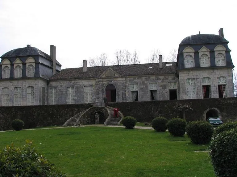
Trenqueléon or Trenquelleon Castle
No reviews yet
Have you flown here? Share your experience with other pilots.
+ Write the first reviewHistory
Le château, qui conserve sur sa face sud une tour paraissant dater du 15e siècle, a été remanié au 18e siècle. La façade sur la cour intérieure date de cette époque. Le corps de logis s'ouvre sur une terrasse surélevée et cailloutée, formant mosaïque. La partie centrale est flanquée de deux pavillons dont la toiture est en forme de coupole à quatre pans et trois ressauts. La porte centrale est surmontée d'un triangle de pierre. Les bâtiments des communs ferment complètement la cour d'entrée. Architecture achevée en 1771 par Charles de Batz-Trenqueléon réalisée pour Elisabeth de Malides qui fréquentait la Cour du Roi. Architecte de renom à identifier. Une petite fille de Charles, Adèle de Batz-Trenqueléon fondera en 1804 l'Institut des Filles de Marie, affilié plus tard à la congrégation de l'Immaculée qui s'appellera plus tard Filles de Marie Immaculée : mère Adèle est donc la fondatrice des Marianistes femmes sous la direction du père Chaminade. Le château de Trenqueléon avec sa chapelle reste donc un lieu de mémoire pour les soeurs marianistes de tous pays.
Map and restricted areas
Open in the main mapRestricted zones
| Zone | Category | Limits | Conditions |
|---|---|---|---|
| Zena Perigord Low | ZRT | FL 165 / FL 195 | SUP AIP 062/26 · Du jeudi 23 avril 2026 au jeudi 25 mars 2027 |
Nearby aerodromes
Open aerodromes within 25 km of the spot, heliports included, with their distance and direction from the spot. Near an aerodrome, drone flying is prohibited or height-limited: check the UAS zones map.
| Aerodrome | Type | Distance | Elevation |
|---|---|---|---|
| Agen-La Garenne Airport | Airport | 21 km E | 62 m |
| Montpezat d'Agenais | Aerodrome | 21 km NE | 37 m |
Aviation weather (METAR and TAF)
LFBA – Agen-La Garenne Airport IFR
METAR
METAR LFBA 171400Z AUTO 26004KT 230V290 2900 +RA BR SCT006/// BKN012/// OVC019/// ///TCU 14/14 Q1003 TEMPO 3000 RA BKN014 BKN035 FEW060CB
- Wind
- 260°, 7 km/h
- Visibility
- 2.9 km
- Weather
- Rain heavy ; mist
- Clouds
- Scattered (3-4/8) at 600 ft (180 m) ; Broken (5-7/8) at 1,200 ft (370 m) ; Overcast (8/8) at 1,900 ft (580 m)
- Temperature
- 14 °C, dew point 14 °C
- QNH
- 1003 hPa
- Flight category
- IFR: ceiling 500–1,000 ft or visibility 1–3 mi
TAF
TAF AMD LFBA 171415Z 1714/1721 25010KT CAVOK TEMPO 1714/1717 2000 RA SCT005 BKN014 BKN035 FEW060CB TEMPO 1719/1721 3000 RA BKN040TCU
| Period (local time) | Change | Wind | Visibility | Weather | Clouds |
|---|---|---|---|---|---|
| 17/11 15:00 → 17/11 22:00 | Initial conditions | 250°, 19 km/h | 10 km or more | No significant weather | No significant cloud |
| 17/11 15:00 → 17/11 18:00 | Temporarily | 2.0 km | Rain | Scattered (3-4/8) at 500 ft (150 m) ; Broken (5-7/8) at 1,400 ft (430 m) ; Broken (5-7/8) at 3,500 ft (1070 m) | |
| 17/11 20:00 → 17/11 22:00 | Temporarily | 3.0 km | Rain | Broken (5-7/8) at 4,000 ft (1220 m) (towering cumulus) |
Weather and Kp index
Sunrise and sunset
| Day | Dawn | Sunrise | Golden hour | Sunset | Dusk | Day length |
|---|---|---|---|---|---|---|
| Tue 17 Nov | 07:25 | 07:57 | 07:57–08:41 · 16:46–17:30 | 17:30 | 18:02 | 9 h 33 |
| Wed 18 Nov | 07:27 | 07:58 | 07:58–08:42 · 16:45–17:30 | 17:30 | 18:01 | 9 h 31 |
| Thu 19 Nov | 07:28 | 07:59 | 07:59–08:44 · 16:44–17:29 | 17:29 | 18:00 | 9 h 29 |
| Fri 20 Nov | 07:29 | 08:01 | 08:01–08:45 · 16:43–17:28 | 17:28 | 17:59 | 9 h 27 |
| Sat 21 Nov | 07:30 | 08:02 | 08:02–08:47 · 16:42–17:27 | 17:27 | 17:59 | 9 h 25 |
| Sun 22 Nov | 07:31 | 08:03 | 08:03–08:48 · 16:41–17:26 | 17:26 | 17:58 | 9 h 23 |
| Mon 23 Nov | 07:33 | 08:04 | 08:04–08:50 · 16:40–17:26 | 17:26 | 17:57 | 9 h 21 |

Reviews (0)
Log in to review this spot. Log in · Create a free account
No reviews yet. Share yours!