

Schoenenbourg Fort (Maginot Line)
No reviews yet
Have you flown here? Share your experience with other pilots.
+ Write the first reviewHistory
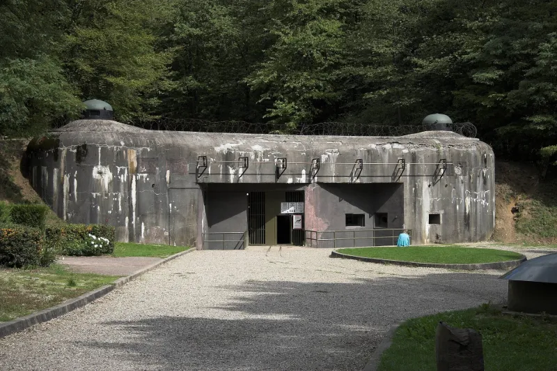
Fort défensif et ouvrage d'artillerie faisant partie du secteur fortifié de Haguenau (ligne Maginot) conçu en 1929 et construit en béton armé de 1930 à 1935. Prévu pour une garnison de 600 hommes, le fort est doté de deux blocs d'entrée, six blocs de combat et trois kilomètres de galeries souterraines avec des voies ferrées électrifiées. Attaqué le 14 mai 1940, l'ouvrage résistait encore au moment de l'armistice du 25 juin 1940, ses défenseurs se rendant le 1er juillet. A l'abandon à partir de 1968, l'ouvrage a été remarquablement restauré et mis en valeur par l'Association des amis de la ligne Maginot ; il est ouvert comme musée depuis 1982.
Map and restricted areas
Open in the main mapRestricted zones
| Zone | Category | Limits | Conditions |
|---|---|---|---|
| R 122 | Zone réglementée | 3053 m above sea level → 6259 m above sea level | Vols interdits sauf lorsque the official document of the zone l'autorise explicitement ou avec l'accord du gestionnaire de la zone lorsqu'il est désigné par the official document of the zone |
Nearby aerodromes
Open aerodromes within 25 km of the spot, heliports included, with their distance and direction from the spot. Near an aerodrome, drone flying is prohibited or height-limited: check the UAS zones map.
| Aerodrome | Type | Distance | Elevation |
|---|---|---|---|
| Base ULM de Wissembourg | Aerodrome | 5.4 km NE | 175 m |
| Schweighofen Airport | Aerodrome | 9.2 km NE | 150 m |
| Base ULM de Salmbach | Aerodrome | 11 km E | 155 m |
| Bundenthal-Rumbach Airfield | Aerodrome | 17 km NW | 303 m |
| Haguenau Airfield | Aerodrome | 20 km S | 150 m |
Aviation weather (METAR and TAF)
EDSB – Karlsruhe Baden-Baden Airport VFR
METAR
METAR EDSB 171420Z AUTO /////KT 9999 BKN048 17/09 Q0993
- Wind
- –
- Visibility
- 10 km or more
- Clouds
- Broken (5-7/8) at 4,800 ft (1460 m)
- Temperature
- 17 °C, dew point 9 °C
- QNH
- 993 hPa
- Flight category
- VFR: ceiling > 3,000 ft and visibility > 5 mi
TAF
TAF EDSB 171100Z 1712/1812 21020G30KT 9999 SCT020 TEMPO 1712/1714 4500 RA BKN012 PROB30 TEMPO 1714/1716 23020G40KT 4000 TSRA BKN012 BKN020CB BECMG 1715/1717 21015G25KT TEMPO 1721/1812 SHRA SCT010 BKN020CB PROB40 TEMPO 1722/1812 22025G40KT 4000 TSRA BKN010 BKN020CB
| Period (local time) | Change | Wind | Visibility | Weather | Clouds |
|---|---|---|---|---|---|
| 17/11 13:00 → 17/11 16:00 | Initial conditions | 210°, 37 km/h, gusts 56 km/h | 10 km or more | Scattered (3-4/8) at 2,000 ft (610 m) | |
| 17/11 13:00 → 17/11 15:00 | Temporarily | 4.5 km | Rain | Broken (5-7/8) at 1,200 ft (370 m) | |
| 17/11 15:00 → 17/11 17:00 | Temporarily, probability 30% | 230°, 37 km/h, gusts 74 km/h | 4.0 km | Thunderstorm rain | Broken (5-7/8) at 1,200 ft (370 m) ; Broken (5-7/8) at 2,000 ft (610 m) (cumulonimbus) |
| 17/11 16:00 → 18/11 13:00 | Becoming | 210°, 28 km/h, gusts 46 km/h | 10 km or more | Scattered (3-4/8) at 2,000 ft (610 m) | |
| 17/11 22:00 → 18/11 13:00 | Temporarily | Showers of rain | Scattered (3-4/8) at 1,000 ft (300 m) ; Broken (5-7/8) at 2,000 ft (610 m) (cumulonimbus) | ||
| 17/11 23:00 → 18/11 13:00 | Temporarily, probability 40% | 220°, 46 km/h, gusts 74 km/h | 4.0 km | Thunderstorm rain | Broken (5-7/8) at 1,000 ft (300 m) ; Broken (5-7/8) at 2,000 ft (610 m) (cumulonimbus) |
Weather and Kp index
Sunrise and sunset
| Day | Dawn | Sunrise | Golden hour | Sunset | Dusk | Day length |
|---|---|---|---|---|---|---|
| Tue 17 Nov | 07:06 | 07:41 | 07:41–08:31 · 15:56–16:46 | 16:46 | 17:21 | 9 h 04 |
| Wed 18 Nov | 07:07 | 07:42 | 07:42–08:33 · 15:54–16:45 | 16:45 | 17:20 | 9 h 02 |
| Thu 19 Nov | 07:09 | 07:44 | 07:44–08:34 · 15:53–16:44 | 16:44 | 17:19 | 8 h 59 |
| Fri 20 Nov | 07:10 | 07:45 | 07:45–08:36 · 15:52–16:43 | 16:43 | 17:18 | 8 h 57 |
| Sat 21 Nov | 07:12 | 07:47 | 07:47–08:38 · 15:50–16:42 | 16:42 | 17:17 | 8 h 54 |
| Sun 22 Nov | 07:13 | 07:48 | 07:48–08:40 · 15:49–16:41 | 16:41 | 17:16 | 8 h 52 |
| Mon 23 Nov | 07:14 | 07:50 | 07:50–08:41 · 15:48–16:40 | 16:40 | 17:15 | 8 h 49 |


Reviews (0)
Log in to review this spot. Log in · Create a free account
No reviews yet. Share yours!