

Heritage
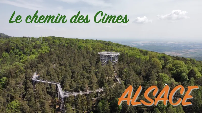
Le chemin des cimes
2 pilot reviews
“Merci pour ton commentaire. N’hésite pas à aller visiter ma chaîne YouTube « balades alsac…” — Jipe1000, 4 years ago
Read the reviews + Write my reviewDescription
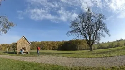
This is a treetop trail accessible to everyone. You enjoy a breathtaking panorama of the Alsatian forest from the observation tower.
Map and restricted areas
Open in the main mapNearby aerodromes
Open aerodromes within 25 km of the spot, heliports included, with their distance and direction from the spot. Near an aerodrome, drone flying is prohibited or height-limited: check the UAS zones map.
| Aerodrome | Type | Distance | Elevation | Difference |
|---|---|---|---|---|
| Base ULM de Wissembourg | Aerodrome | 8.8 km E | 175 m | spot 290 m higher |
| Schweighofen Airport | Aerodrome | 10 km E | 150 m | spot 315 m higher |
| Bundenthal-Rumbach Airfield | Aerodrome | 11 km NW | 303 m | spot 162 m higher |
| Base ULM de Salmbach | Aerodrome | 16 km E | 155 m | spot 310 m higher |
| Haguenau Airfield | Aerodrome | 23 km S | 150 m | spot 315 m higher |
Aviation weather (METAR and TAF)
EDSB – Karlsruhe Baden-Baden Airport VFR
METAR
METAR EDSB 211050Z AUTO VRB02KT CAVOK 08/03 Q1020
- Wind
- Variable, 4 km/h
- Visibility
- 10 km or more
- Clouds
- –
- Temperature
- 8 °C, dew point 3 °C
- QNH
- 1020 hPa
- Flight category
- VFR: ceiling > 3,000 ft and visibility > 5 mi
TAF
TAF EDSB 210500Z 2106/2206 VRB03KT 9999 SCT030 BECMG 2200/2203 03005KT PROB30 TEMPO 2202/2206 1500 BR BKN003
| Period (local time) | Change | Wind | Visibility | Weather | Clouds |
|---|---|---|---|---|---|
| 21/11 07:00 → 22/11 01:00 | Initial conditions | Variable, 6 km/h | 10 km or more | Scattered (3-4/8) at 3,000 ft (910 m) | |
| 22/11 01:00 → 22/11 07:00 | Becoming | 030°, 9 km/h | 10 km or more | Scattered (3-4/8) at 3,000 ft (910 m) | |
| 22/11 03:00 → 22/11 07:00 | Temporarily, probability 30% | 1.5 km | Mist | Broken (5-7/8) at 300 ft (90 m) |
Weather and Kp index
| Day | Weather | Temp. min. / max. | Wind | Rain | Max Kp |
|---|---|---|---|---|---|
| Sat 21 Nov | Clear sky | 1° / 8° | 8 km/h N | – | 2 |
| Sun 22 Nov | Light rain | 0° / 4° | 22 km/h NE | 1.4 mm | 2 |
| Mon 23 Nov | Partly cloudy | -5° / 2° | 15 km/h NE | – | 4 |
| Tue 24 Nov | Clear sky | -5° / 1° | 17 km/h NE | – | 2 |
| Wed 25 Nov | Cloudy | -4° / 0° | 24 km/h NE | – | – |
| Thu 26 Nov | Cloudy | -3° / 0° | 21 km/h NE | 0.3 mm | – |
| Fri 27 Nov | Cloudy | -1° / 2° | 6 km/h NE | 0.1 mm | – |
Hour by hour: Saturday 21 November
| Time | Weather | Temp. | Wind | Rain | Clouds | Kp |
|---|---|---|---|---|---|---|
| 12:00 | Clear sky | 7° | 5 km/h SW | – | 1 % | 2 |
| 13:00 | Clear sky | 7° | 5 km/h SW | – | 0 % | 1 |
| 14:00 | Clear sky | 8° | 4 km/h SW | – | 2 % | 1 |
| 15:00 | Clear sky | 7° | 5 km/h SW | – | 1 % | 1 |
| 16:00 | Clear sky | 6° | 4 km/h S | – | 2 % | 2 |
| 17:00 | Clear sky | 4° | 5 km/h SW | – | 0 % | 2 |
| 18:00 | Clear sky | 3° | 4 km/h SW | – | 2 % | 2 |
| 19:00 | Clear sky | 3° | 2 km/h W | – | 5 % | 2 |
| 20:00 | Clear sky | 2° | 1 km/h W | – | 9 % | 2 |
| 21:00 | Clear sky | 2° | 4 km/h N | – | 4 % | 2 |
| 22:00 | Partly cloudy | 1° | 6 km/h N | – | 47 % | 2 |
Hour by hour: Sunday 22 November
| Time | Weather | Temp. | Wind | Rain | Clouds | Kp |
|---|---|---|---|---|---|---|
| 06:00 | Partly cloudy | 0° | 15 km/h NE | – | 100 % | 2 |
| 07:00 | Cloudy | 1° | 16 km/h NE | – | 100 % | 2 |
| 08:00 | Cloudy | 1° | 17 km/h NE | – | 100 % | 2 |
| 09:00 | Cloudy | 1° | 18 km/h NE | – | 100 % | 2 |
| 10:00 | Cloudy | 2° | 22 km/h NE | – | 100 % | 2 |
| 11:00 | Cloudy | 2° | 17 km/h NE | – | 100 % | 2 |
| 12:00 | Cloudy | 3° | 16 km/h NE | – | 100 % | 2 |
| 13:00 | Light rain | 4° | 15 km/h NE | 0.1 mm | 100 % | 2 |
| 14:00 | Light rain | 4° | 13 km/h NE | 0.2 mm | 100 % | 2 |
| 15:00 | Light rain | 4° | 13 km/h NE | 0.3 mm | 100 % | 2 |
| 16:00 | Light rain | 3° | 14 km/h NE | 0.3 mm | 100 % | 2 |
| 17:00 | Light rain | 2° | 14 km/h NE | 0.3 mm | 100 % | 2 |
| 18:00 | Sleet | 2° | 15 km/h NE | 0.2 mm | 100 % | 2 |
| 19:00 | Cloudy | 2° | 18 km/h NE | – | 100 % | 2 |
| 20:00 | Cloudy | 2° | 19 km/h NE | – | 100 % | 2 |
| 21:00 | Cloudy | 2° | 18 km/h NE | – | 100 % | 2 |
| 22:00 | Partly cloudy | 1° | 17 km/h NE | – | 97 % | 2 |
Sunrise and sunset
| Day | Dawn | Sunrise | Golden hour | Sunset | Dusk | Day length |
|---|---|---|---|---|---|---|
| Sat 21 Nov | 07:12 | 07:47 | 07:47–08:38 · 15:51–16:42 | 16:42 | 17:17 | 8 h 54 |
| Sun 22 Nov | 07:13 | 07:49 | 07:49–08:40 · 15:49–16:41 | 16:41 | 17:16 | 8 h 52 |
| Mon 23 Nov | 07:15 | 07:50 | 07:50–08:42 · 15:48–16:40 | 16:40 | 17:15 | 8 h 49 |
| Tue 24 Nov | 07:16 | 07:52 | 07:52–08:43 · 15:47–16:39 | 16:39 | 17:14 | 8 h 47 |
| Wed 25 Nov | 07:17 | 07:53 | 07:53–08:45 · 15:46–16:38 | 16:38 | 17:14 | 8 h 45 |
| Thu 26 Nov | 07:19 | 07:54 | 07:54–08:47 · 15:45–16:37 | 16:37 | 17:13 | 8 h 42 |
| Fri 27 Nov | 07:20 | 07:56 | 07:56–08:48 · 15:44–16:37 | 16:37 | 17:12 | 8 h 40 |

Reviews
Log in to review this spot. Log in · Create a free account
Jipe1000
Merci pour ton commentaire. N’hésite pas à aller visiter ma chaîne YouTube « balades alsaciennes », j’ai plein d’autres vidéos… A bientôt
jypai83
Salut, super la vidéo ça donne envie de découvrir le lieu c'est ce que j'aime.