

Castle
No reviews yet
Have you flown here? Share your experience with other pilots.
+ Write the first reviewHistory
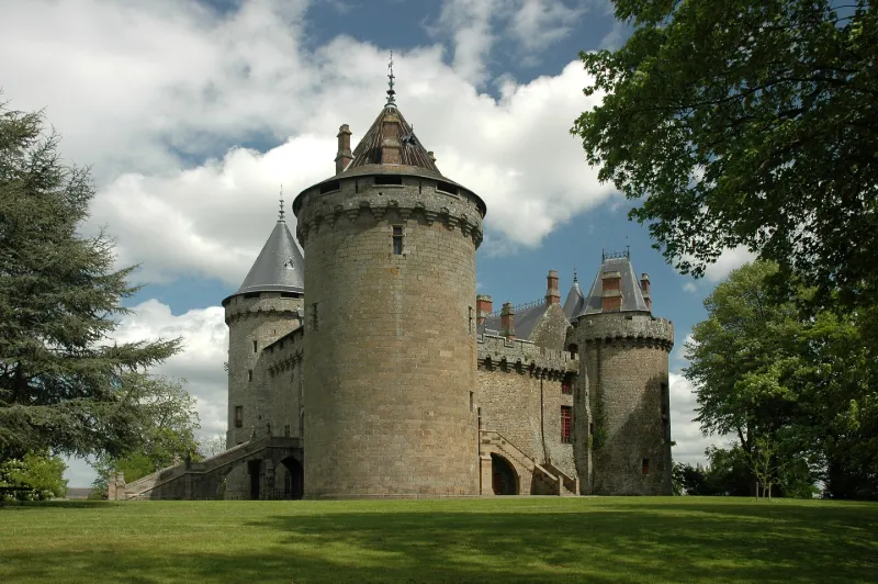
La seigneurie de Combourg était un démembrement de la seigneurie des archevêques de Dol et relevait sans doute, à l'origine, des archevêques. Elle parvint à s'affranchir de cette suzeraineté ecclésiastique et à relever presque uniquement du Duc. Le château fut construit vers 1025 par l'archevêque Guinguené qui le donna à son frère bâtard Riwallon. C'est en 1761 que la famille de Chateaubriand en acquit la propriété. Restauré en 1866 et en 1878, le château se compose de quatre vastes et puissants bâtiments en granit appareillé, munis de créneaux et mâchicoulis enfermant une cour rectangulaire. Cette massive forteresse est flanquée, aux quatre angles, de tours rondes à créneaux et mâchicoulis, à toitures coniques. Les mâchicoulis de la courtine nord et ceux de la tour nord-ouest présentent sur leurs trois faces des encorbellements à quatre ressauts ; ceux de la tour nord-est sont à trois ressauts seulement ; ils supportent des linteaux ornés de trilobes simulés inscrits dans des arcatures brisées. L'intérieur a été également entièrement restauré. Sa chapelle se voit encore à l'entrée du vestibule d'honneur. La grande salle des Gardes forme aujourd'hui deux salons. Le parc actuel remplace d'anciens mails.
Map and restricted areas
Open in the main mapRestricted zones
Nearby aerodromes
Open aerodromes within 25 km of the spot, heliports included, with their distance and direction from the spot. Near an aerodrome, drone flying is prohibited or height-limited: check the UAS zones map.
No known open aerodrome within 25 km.
Aviation weather (METAR and TAF)
LFRD – Dinard-Pleurtuit-Saint-Malo Airport MVFR
METAR
METAR LFRD 171400Z AUTO 23021G36KT 9999 OVC030 OVC036 16/11 Q0988 TEMPO 1400 TSRAGS BKN008 BKN020CB
- Wind
- 230°, 39 km/h, gusts 67 km/h
- Visibility
- 10 km or more
- Clouds
- Overcast (8/8) at 3,000 ft (910 m) ; Overcast (8/8) at 3,600 ft (1100 m)
- Temperature
- 16 °C, dew point 11 °C
- QNH
- 988 hPa
- Flight category
- MVFR: ceiling 1,000–3,000 ft or visibility 3–5 mi
TAF
TAF LFRD 171100Z 1712/1812 25020G30KT 9999 BKN020 TEMPO 1712/1812 3000 SHRA BKN012 SCT020CB SCT025TCU PROB40 TEMPO 1712/1716 23025G45KT 1400 TSRAGS BKN008 BKN020CB PROB30 TEMPO 1800/1806 1400 TSRA
| Period (local time) | Change | Wind | Visibility | Weather | Clouds |
|---|---|---|---|---|---|
| 17/11 13:00 → 18/11 13:00 | Initial conditions | 250°, 37 km/h, gusts 56 km/h | 10 km or more | Broken (5-7/8) at 2,000 ft (610 m) | |
| 17/11 13:00 → 18/11 13:00 | Temporarily | 3.0 km | Showers of rain | Broken (5-7/8) at 1,200 ft (370 m) ; Scattered (3-4/8) at 2,000 ft (610 m) (cumulonimbus) ; Scattered (3-4/8) at 2,500 ft (760 m) (towering cumulus) | |
| 17/11 13:00 → 17/11 17:00 | Temporarily, probability 40% | 230°, 46 km/h, gusts 83 km/h | 1.4 km | Thunderstorm rain ; thunderstorm small hail | Broken (5-7/8) at 800 ft (240 m) ; Broken (5-7/8) at 2,000 ft (610 m) (cumulonimbus) |
| 18/11 01:00 → 18/11 07:00 | Temporarily, probability 30% | 1.4 km | Thunderstorm rain |
Weather and Kp index
Sunrise and sunset
| Day | Dawn | Sunrise | Golden hour | Sunset | Dusk | Day length |
|---|---|---|---|---|---|---|
| Tue 17 Nov | 07:43 | 08:18 | 08:18–09:07 · 16:37–17:26 | 17:26 | 18:01 | 9 h 08 |
| Wed 18 Nov | 07:45 | 08:19 | 08:19–09:09 · 16:36–17:25 | 17:25 | 18:00 | 9 h 05 |
| Thu 19 Nov | 07:46 | 08:21 | 08:21–09:10 · 16:34–17:24 | 17:24 | 17:59 | 9 h 03 |
| Fri 20 Nov | 07:48 | 08:22 | 08:22–09:12 · 16:33–17:23 | 17:23 | 17:58 | 9 h 00 |
| Sat 21 Nov | 07:49 | 08:24 | 08:24–09:14 · 16:32–17:22 | 17:22 | 17:57 | 8 h 58 |
| Sun 22 Nov | 07:50 | 08:25 | 08:25–09:16 · 16:31–17:21 | 17:21 | 17:56 | 8 h 56 |
| Mon 23 Nov | 07:52 | 08:26 | 08:26–09:17 · 16:30–17:20 | 17:20 | 17:55 | 8 h 53 |



Reviews (0)
Log in to review this spot. Log in · Create a free account
No reviews yet. Share yours!