

Grippel Tower
No reviews yet
Have you flown here? Share your experience with other pilots.
+ Write the first reviewHistory
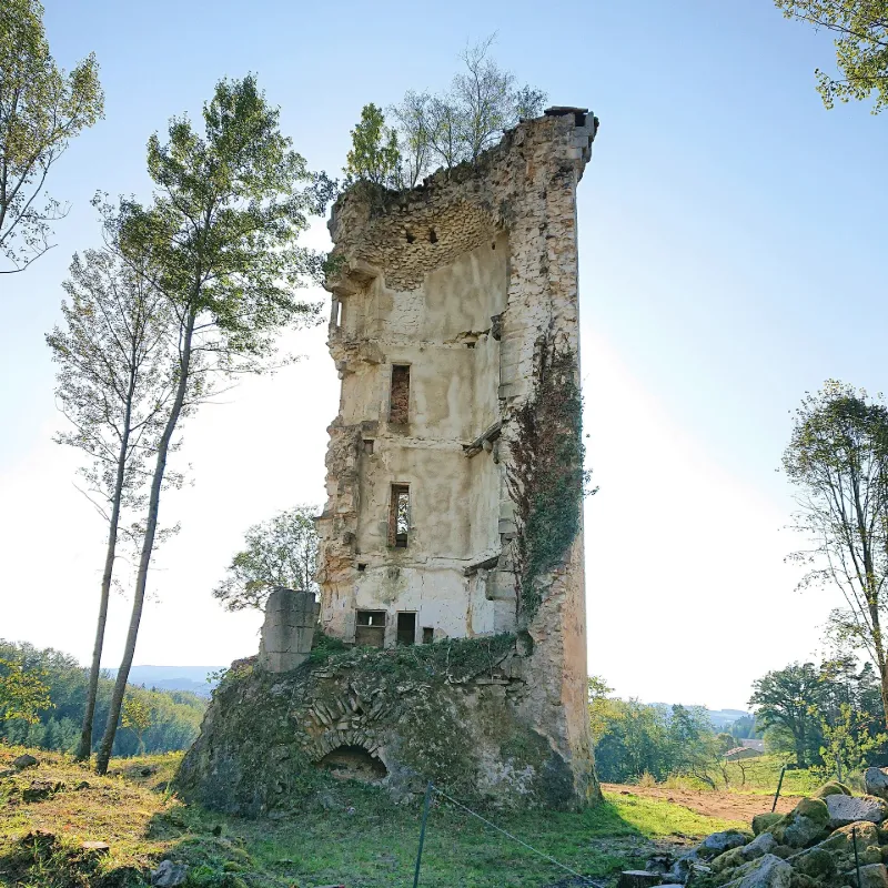
Cette tour est un exemple intéressant des nombreux ouvrages fortifiés qui témoignent du passé régional. Bertrand de la Tour, seigneur d'Olliergues, donne permission à Pierre de la Tour de fortifier son château en 1429. C'est probablement à la suite de cette autorisation que fut construite ou profondément remaniée la tour dont le couronnement n'est pas antérieur à la fin du 15e siècle. L'ouvrage se présente comme un donjon circulaire, isolé et indépendant, procédant de la tradition romane. La disposition des ouvertures extérieures permet de penser que cette construction possède trois étages au-dessus d'un rez-de-chaussée surélevé. Les ouvertures les plus basses étaient défendues par des grilles. Trois fentes étroites chanfreinées s'ouvrant à des hauteurs différentes devaient probablement éclairer l'escalier accédant aux étages et au couronnement. Le crénelage qui devait primitivement couronner la tour, a été démoli. Une rangée de mâchicoulis, dont les linteaux sont ornés d'une accolade, subsite intacte.
Map and restricted areas
Open in the main mapRestricted zones
Nearby aerodromes
Open aerodromes within 25 km of the spot, heliports included, with their distance and direction from the spot. Near an aerodrome, drone flying is prohibited or height-limited: check the UAS zones map.
| Aerodrome | Type | Distance | Elevation |
|---|---|---|---|
| Col du Béal Altiport | Aerodrome | 7.1 km E | 1,470 m |
| Ambert Le Poyet Airport | Aerodrome | 18 km S | 563 m |
Aviation weather (METAR and TAF)
LFLC – Clermont-Ferrand Auvergne Airport VFR
METAR
METAR LFLC 171400Z AUTO 15012G27KT 120V190 9999 BKN053 BKN190 OVC210 18/08 Q1000
- Wind
- 150°, 22 km/h, gusts 50 km/h
- Visibility
- 10 km or more
- Clouds
- Broken (5-7/8) at 5,300 ft (1620 m) ; Broken (5-7/8) at 19,000 ft (5790 m) ; Overcast (8/8) at 21,000 ft (6400 m)
- Temperature
- 18 °C, dew point 8 °C
- QNH
- 1000 hPa
- Flight category
- VFR: ceiling > 3,000 ft and visibility > 5 mi
TAF
TAF LFLC 170500Z 1706/1806 19012KT CAVOK TEMPO 1706/1710 19018G30KT -RA BKN050 PROB30 TEMPO 1707/1710 22025G45KT RA BKN020 FM171000 22012KT CAVOK TEMPO 1710/1717 22018G30KT PROB30 TEMPO 1714/1717 -SHRA BKN060TCU FM171700 25015KT CAVOK TEMPO 1717/1806 25018G30KT PROB30 TEMPO 1720/1723 25025G45KT SHRA BKN060TCU
| Period (local time) | Change | Wind | Visibility | Weather | Clouds |
|---|---|---|---|---|---|
| 17/11 07:00 → 17/11 11:00 | Initial conditions | 190°, 22 km/h | 10 km or more | No significant weather | No significant cloud |
| 17/11 07:00 → 17/11 11:00 | Temporarily | 190°, 33 km/h, gusts 56 km/h | Rain light | Broken (5-7/8) at 5,000 ft (1520 m) | |
| 17/11 08:00 → 17/11 11:00 | Temporarily, probability 30% | 220°, 46 km/h, gusts 83 km/h | Rain | Broken (5-7/8) at 2,000 ft (610 m) | |
| 17/11 11:00 → 17/11 18:00 | From | 220°, 22 km/h | 10 km or more | No significant weather | No significant cloud |
| 17/11 11:00 → 17/11 18:00 | Temporarily | 220°, 33 km/h, gusts 56 km/h | |||
| 17/11 15:00 → 17/11 18:00 | Temporarily, probability 30% | Showers of rain light | Broken (5-7/8) at 6,000 ft (1830 m) (towering cumulus) | ||
| 17/11 18:00 → 18/11 07:00 | Temporarily | 250°, 33 km/h, gusts 56 km/h | |||
| 17/11 18:00 → 18/11 07:00 | From | 250°, 28 km/h | 10 km or more | No significant weather | No significant cloud |
| 17/11 21:00 → 18/11 00:00 | Temporarily, probability 30% | 250°, 46 km/h, gusts 83 km/h | Showers of rain | Broken (5-7/8) at 6,000 ft (1830 m) (towering cumulus) |
Weather and Kp index
Sunrise and sunset
| Day | Dawn | Sunrise | Golden hour | Sunset | Dusk | Day length |
|---|---|---|---|---|---|---|
| Tue 17 Nov | 07:15 | 07:47 | 07:47–08:33 · 16:27–17:13 | 17:13 | 17:45 | 9 h 25 |
| Wed 18 Nov | 07:16 | 07:49 | 07:49–08:35 · 16:26–17:12 | 17:12 | 17:44 | 9 h 23 |
| Thu 19 Nov | 07:18 | 07:50 | 07:50–08:36 · 16:25–17:11 | 17:11 | 17:43 | 9 h 20 |
| Fri 20 Nov | 07:19 | 07:52 | 07:52–08:38 · 16:24–17:10 | 17:10 | 17:43 | 9 h 18 |
| Sat 21 Nov | 07:20 | 07:53 | 07:53–08:39 · 16:23–17:09 | 17:09 | 17:42 | 9 h 16 |
| Sun 22 Nov | 07:21 | 07:54 | 07:54–08:41 · 16:22–17:08 | 17:08 | 17:41 | 9 h 14 |
| Mon 23 Nov | 07:23 | 07:55 | 07:55–08:42 · 16:21–17:08 | 17:08 | 17:41 | 9 h 12 |

Reviews (0)
Log in to review this spot. Log in · Create a free account
No reviews yet. Share yours!