

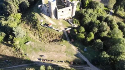
Villechaize Castle
No reviews yet
Have you flown here? Share your experience with other pilots.
+ Write the first reviewHistory
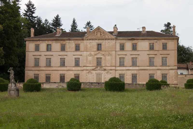
Le domaine se compose d'un bâtiment principal avec les communs à l'arrière, séparés par une cour. L'ensemble est clos de murs. L'avant-corps central est surmonté d'un fronton décoré de lions encadrant un blason. Certains communs sont plus anciens que le château qui date du 18e siècle. Sur l'arrière d'un commun se trouve un vestige de l'ancien château, une tour arasée. Les pièces possèdent toutes cheminée, boiseries, soieries, tapisseries, plafonds peints et parquets, chacune étant différente dans le traitement du décor. Le premier étage contient les chambres. Au premier niveau, chapelle avec décor peint et un vitrail de Georges Nicolas Dufetre. Les décors datent du 19e siècle. La composition actuelle du parc a été établie selon un plan de Gabriel Luizet, de 1916. C'est un jardin régulier qui se compose d'une succession de trois terrasses maçonnées. Un mur de soutènement contre lequel s'appuie une chapelle en ruine, sépare la dernière terrasse des prairies du domaine. La statuaire du jardin est riche.
Map and restricted areas
Open in the main mapRestricted zones
Nearby aerodromes
Open aerodromes within 25 km of the spot, heliports included, with their distance and direction from the spot. Near an aerodrome, drone flying is prohibited or height-limited: check the UAS zones map.
| Aerodrome | Type | Distance | Elevation |
|---|---|---|---|
| Col du Béal Altiport | Aerodrome | 16 km S | 1,470 m |
Aviation weather (METAR and TAF)
LFMH – Saint-Étienne-Bouthéon Airport VFR
METAR
METAR LFMH 171400Z AUTO 22010KT 190V250 9999 FEW049 19/08 Q1001
- Wind
- 220°, 19 km/h
- Visibility
- 10 km or more
- Clouds
- Few (1-2/8) at 4,900 ft (1490 m)
- Temperature
- 19 °C, dew point 8 °C
- QNH
- 1001 hPa
- Flight category
- VFR: ceiling > 3,000 ft and visibility > 5 mi
TAF
Weather and Kp index
| Day | Weather | Temp. min. / max. | Wind | Rain | Max Kp |
|---|---|---|---|---|---|
| Tue 17 Nov | Fair | 10° / 14° | 27 km/h SW | 1.3 mm | 5 |
| Wed 18 Nov | Showers | 8° / 11° | 26 km/h W | 9.4 mm | 5 |
| Thu 19 Nov | Showers | 6° / 10° | 31 km/h W | 8.3 mm | 3 |
| Fri 20 Nov | Showers | 6° / 9° | 26 km/h SW | 2.7 mm | 3 |
| Sat 21 Nov | Clear sky | 6° / 11° | 18 km/h W | 1.2 mm | – |
| Sun 22 Nov | Showers | 7° / 10° | 28 km/h W | 8.8 mm | – |
| Mon 23 Nov | Partly cloudy | 4° / 8° | 24 km/h W | 1.3 mm | – |
Hour by hour: Tuesday 17 November
| Time | Weather | Temp. | Wind | Rain | Clouds | Kp |
|---|---|---|---|---|---|---|
| 15:00 | Fair | 14° | 23 km/h SW | – | 23 % | 4 |
| 16:00 | Partly cloudy | 13° | 26 km/h SW | – | 41 % | 4 |
| 17:00 | Fair | 12° | 22 km/h SW | – | 26 % | 4 |
| 18:00 | Fair | 11° | 22 km/h SW | – | 28 % | 4 |
| 19:00 | Cloudy | 10° | 22 km/h SW | – | 97 % | 5 |
| 20:00 | Cloudy | 10° | 23 km/h SW | – | 94 % | 5 |
| 21:00 | Light rain | 11° | 27 km/h SW | 0.1 mm | 100 % | 5 |
| 22:00 | Light rain | 10° | 26 km/h SW | 0.3 mm | 100 % | 5 |
Hour by hour: Wednesday 18 November
| Time | Weather | Temp. | Wind | Rain | Clouds | Kp |
|---|---|---|---|---|---|---|
| 06:00 | Showers | 9° | 24 km/h W | 0.1 mm | 33 % | 4 |
| 07:00 | Showers | 8° | 19 km/h W | 0.1 mm | 83 % | 4 |
| 08:00 | Partly cloudy | 8° | 19 km/h SW | – | 44 % | 4 |
| 09:00 | Partly cloudy | 8° | 20 km/h SW | – | 78 % | 4 |
| 10:00 | Heavy rain | 9° | 22 km/h W | 1.2 mm | 90 % | 4 |
| 11:00 | Showers | 9° | 25 km/h W | 0.7 mm | 52 % | 4 |
| 12:00 | Fair | 10° | 25 km/h W | – | 34 % | 4 |
| 13:00 | Showers | 11° | 26 km/h W | 0.2 mm | 62 % | 3 |
| 14:00 | Cloudy | 11° | 24 km/h SW | – | 88 % | 3 |
| 15:00 | Light rain | 11° | 24 km/h SW | 0.4 mm | 98 % | 3 |
| 16:00 | Light rain | 10° | 22 km/h SW | 0.4 mm | 98 % | 3 |
| 17:00 | Cloudy | 9° | 18 km/h SW | – | 100 % | 3 |
| 18:00 | Cloudy | 9° | 17 km/h SW | – | 93 % | 3 |
| 19:00 | Cloudy | 9° | 18 km/h SW | – | 87 % | 2 |
| 20:00 | Cloudy | 9° | 19 km/h SW | – | 97 % | 2 |
| 21:00 | Cloudy | 8° | 18 km/h SW | – | 96 % | 2 |
| 22:00 | Cloudy | 8° | 17 km/h SW | – | 97 % | 2 |
Sunrise and sunset
| Day | Dawn | Sunrise | Golden hour | Sunset | Dusk | Day length |
|---|---|---|---|---|---|---|
| Tue 17 Nov | 07:15 | 07:47 | 07:47–08:33 · 16:26–17:12 | 17:12 | 17:44 | 9 h 24 |
| Wed 18 Nov | 07:16 | 07:49 | 07:49–08:35 · 16:25–17:11 | 17:11 | 17:43 | 9 h 22 |
| Thu 19 Nov | 07:18 | 07:50 | 07:50–08:37 · 16:24–17:10 | 17:10 | 17:43 | 9 h 19 |
| Fri 20 Nov | 07:19 | 07:51 | 07:51–08:38 · 16:23–17:09 | 17:09 | 17:42 | 9 h 17 |
| Sat 21 Nov | 07:20 | 07:53 | 07:53–08:40 · 16:22–17:08 | 17:08 | 17:41 | 9 h 15 |
| Sun 22 Nov | 07:21 | 07:54 | 07:54–08:41 · 16:21–17:07 | 17:07 | 17:40 | 9 h 13 |
| Mon 23 Nov | 07:23 | 07:55 | 07:55–08:43 · 16:20–17:07 | 17:07 | 17:40 | 9 h 11 |
Reviews (0)
Log in to review this spot. Log in · Create a free account
No reviews yet. Share yours!