

Théoule Water Mill
No reviews yet
Have you flown here? Share your experience with other pilots.
+ Write the first reviewHistory
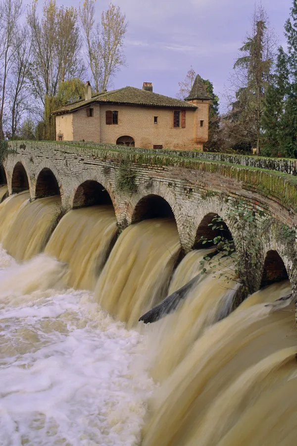
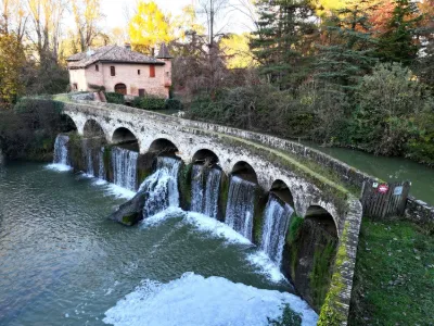
Edifié entre 1480 et 1520 par les moines cisterciens de l'abbaye de Belleperche dont il dépendait, ce moulin à farine fortifié pourvu de deux échauguettes, dont l'une dérasée et de trois meurtrières en façade, a l'allure d'un manoir. Le corps de bâtiment, en brique romaine, comprenait le logement du meunier. Il est solidaire d'un pont barrage, appelé "Pont des Anes", au tracé tourmenté et sinusoïdal, à onze arches d'ouverture modulée, construit en brique et reposant sur des assises en pierre de taille. Le moulin, installé dans la partie terminale d'une rivière de plus de 130 kilomètres, était équipé en 1919 de quatre paires de meules dont subsistent les chambres d'eau et les rouets en métal, ainsi que la turbine produisant l'électricité. Fonctionnant jusqu'en 1952, il a été restauré de 1977 à 1980.
Map and restricted areas
Open in the main mapRestricted zones
Nearby aerodromes
Open aerodromes within 25 km of the spot, heliports included, with their distance and direction from the spot. Near an aerodrome, drone flying is prohibited or height-limited: check the UAS zones map.
| Aerodrome | Type | Distance | Elevation |
|---|---|---|---|
| Fromissard ULM | Aerodrome | 9.2 km E | 96 m |
| Aérodrome de Castelsarrasin Moissac | Aerodrome | 11 km N | 74 m |
| Base ULM du Burgaud | Aerodrome | 19 km S | 183 m |
| Aérodrome Morin - Védrines | Aerodrome | 21 km E | 107 m |
Aviation weather (METAR and TAF)
LFBO – Toulouse-Blagnac Airport MVFR
METAR
METAR LFBO 171330Z AUTO 03004KT 320V080 9999 OVC024 14/13 Q1004 TEMPO 4000 RA BKN010
- Wind
- 030°, 7 km/h
- Visibility
- 10 km or more
- Clouds
- Overcast (8/8) at 2,400 ft (730 m)
- Temperature
- 14 °C, dew point 13 °C
- QNH
- 1004 hPa
- Flight category
- MVFR: ceiling 1,000–3,000 ft or visibility 3–5 mi
TAF
TAF LFBO 171100Z 1712/1818 18006KT 9999 BKN038 TEMPO 1712/1717 4000 RA BKN010 TEMPO 1717/1720 8000 -RA BKN014 BECMG 1720/1722 CAVOK BECMG 1803/1805 33006KT BECMG 1805/1807 4000 -RA BKN013 BKN040 BECMG 1807/1809 25010KT BECMG 1809/1811 9999 NSW BKN030 BECMG 1816/1818 19006KT CAVOK
| Period (local time) | Change | Wind | Visibility | Weather | Clouds |
|---|---|---|---|---|---|
| 17/11 13:00 → 17/11 21:00 | Initial conditions | 180°, 11 km/h | 10 km or more | Broken (5-7/8) at 3,800 ft (1160 m) | |
| 17/11 13:00 → 17/11 18:00 | Temporarily | 4.0 km | Rain | Broken (5-7/8) at 1,000 ft (300 m) | |
| 17/11 18:00 → 17/11 21:00 | Temporarily | 8 km | Rain light | Broken (5-7/8) at 1,400 ft (430 m) | |
| 17/11 21:00 → 18/11 04:00 | Becoming | 180°, 11 km/h | 10 km or more | No significant weather | No significant cloud |
| 18/11 04:00 → 18/11 06:00 | Becoming | 330°, 11 km/h | 10 km or more | No significant weather | No significant cloud |
| 18/11 06:00 → 18/11 08:00 | Becoming | 330°, 11 km/h | 4.0 km | Rain light | Broken (5-7/8) at 1,300 ft (400 m) ; Broken (5-7/8) at 4,000 ft (1220 m) |
| 18/11 08:00 → 18/11 10:00 | Becoming | 250°, 19 km/h | 4.0 km | Rain light | Broken (5-7/8) at 1,300 ft (400 m) ; Broken (5-7/8) at 4,000 ft (1220 m) |
| 18/11 10:00 → 18/11 17:00 | Becoming | 250°, 19 km/h | 10 km or more | No significant weather | Broken (5-7/8) at 3,000 ft (910 m) |
| 18/11 17:00 → 18/11 19:00 | Becoming | 190°, 11 km/h | 10 km or more | No significant weather | No significant cloud |
Weather and Kp index
| Day | Weather | Temp. min. / max. | Wind | Rain | Max Kp |
|---|---|---|---|---|---|
| Tue 17 Nov | Rain | 12° / 14° | 17 km/h SW | 11 mm | 5 |
| Wed 18 Nov | Fair | 12° / 18° | 24 km/h W | 5.0 mm | 5 |
| Thu 19 Nov | Showers | 10° / 14° | 32 km/h W | 11 mm | 3 |
| Fri 20 Nov | Fair | 10° / 15° | 27 km/h W | 2.4 mm | 3 |
| Sat 21 Nov | Cloudy | 8° / 15° | 12 km/h E | 0.9 mm | – |
| Sun 22 Nov | Showers | 11° / 15° | 28 km/h W | 4.9 mm | – |
| Mon 23 Nov | Cloudy | 8° / 14° | 14 km/h SW | – | – |
Hour by hour: Tuesday 17 November
| Time | Weather | Temp. | Wind | Rain | Clouds | Kp |
|---|---|---|---|---|---|---|
| 15:00 | Rain | 14° | 11 km/h W | 0.4 mm | 100 % | 4 |
| 16:00 | Heavy rain | 13° | 8 km/h NW | 1.4 mm | 100 % | 4 |
| 17:00 | Heavy rain | 13° | 8 km/h SE | 2.1 mm | 100 % | 4 |
| 18:00 | Heavy rain | 12° | 8 km/h NE | 1.7 mm | 100 % | 4 |
| 19:00 | Heavy rain | 12° | 8 km/h S | 1.7 mm | 100 % | 5 |
| 20:00 | Heavy rain | 12° | 10 km/h S | 1.4 mm | 100 % | 5 |
| 21:00 | Heavy rain | 12° | 12 km/h S | 1.2 mm | 100 % | 5 |
| 22:00 | Heavy rain | 13° | 13 km/h SW | 1.2 mm | 100 % | 5 |
Hour by hour: Wednesday 18 November
| Time | Weather | Temp. | Wind | Rain | Clouds | Kp |
|---|---|---|---|---|---|---|
| 06:00 | Partly cloudy | 14° | 21 km/h W | – | 53 % | 4 |
| 07:00 | Cloudy | 14° | 23 km/h W | – | 98 % | 4 |
| 08:00 | Cloudy | 14° | 23 km/h W | – | 100 % | 4 |
| 09:00 | Fair | 14° | 21 km/h W | – | 26 % | 4 |
| 10:00 | Fair | 15° | 19 km/h W | – | 34 % | 4 |
| 11:00 | Clear sky | 15° | 21 km/h SW | – | 3 % | 4 |
| 12:00 | Fair | 16° | 23 km/h W | – | 20 % | 4 |
| 13:00 | Fair | 17° | 24 km/h W | – | 22 % | 3 |
| 14:00 | Fair | 17° | 22 km/h W | – | 21 % | 3 |
| 15:00 | Fair | 18° | 19 km/h W | – | 18 % | 3 |
| 16:00 | Clear sky | 17° | 15 km/h W | – | 7 % | 3 |
| 17:00 | Fair | 15° | 8 km/h SW | – | 25 % | 3 |
| 18:00 | Partly cloudy | 13° | 7 km/h S | – | 97 % | 3 |
| 19:00 | Cloudy | 12° | 9 km/h S | – | 99 % | 2 |
| 20:00 | Cloudy | 13° | 15 km/h SE | – | 100 % | 2 |
| 21:00 | Cloudy | 13° | 17 km/h SE | – | 100 % | 2 |
| 22:00 | Heavy rain | 14° | 20 km/h SE | 1.6 mm | 100 % | 2 |
Sunrise and sunset
| Day | Dawn | Sunrise | Golden hour | Sunset | Dusk | Day length |
|---|---|---|---|---|---|---|
| Tue 17 Nov | 07:22 | 07:53 | 07:53–08:37 · 16:44–17:28 | 17:28 | 17:59 | 9 h 34 |
| Wed 18 Nov | 07:23 | 07:54 | 07:54–08:39 · 16:43–17:27 | 17:27 | 17:58 | 9 h 32 |
| Thu 19 Nov | 07:24 | 07:56 | 07:56–08:40 · 16:42–17:26 | 17:26 | 17:58 | 9 h 30 |
| Fri 20 Nov | 07:25 | 07:57 | 07:57–08:41 · 16:41–17:25 | 17:25 | 17:57 | 9 h 28 |
| Sat 21 Nov | 07:27 | 07:58 | 07:58–08:43 · 16:40–17:25 | 17:25 | 17:56 | 9 h 26 |
| Sun 22 Nov | 07:28 | 07:59 | 07:59–08:44 · 16:39–17:24 | 17:24 | 17:55 | 9 h 24 |
| Mon 23 Nov | 07:29 | 08:01 | 08:01–08:46 · 16:38–17:23 | 17:23 | 17:55 | 9 h 22 |


Reviews (0)
Log in to review this spot. Log in · Create a free account
No reviews yet. Share yours!