

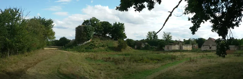
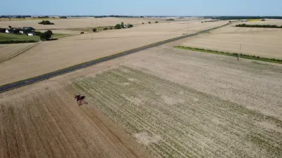
Remains of Bourg-le-Château Castle
No reviews yet
Have you flown here? Share your experience with other pilots.
+ Write the first reviewHistory
Le château est cité pour la première fois dans une bulle d'Alexandre III de 1163. L'édifice comprend trois enceintes : celle de la motte du donjon, celle de la basse cour, celle de la grande cour communiquant avec la précédente par un pont-levis. Le donjon est une tour circulaire avec chemin de ronde fermé par une enceinte ovale, flanqué au nord de deux tours. L'accès à la basse cour se fait par un portail cintré flanqué de deux tours. Casemates dans l'enceinte voûtée en berceau. Au fond de la grande cour se trouve le manoir du 15e siècle.
Map and restricted areas
Open in the main mapRestricted zones
| Zone | Category | Limits | Conditions |
|---|---|---|---|
| Avord | Zone réglementée | 914 m above sea level → 2297 m above sea level | Vols interdits sauf lorsque the official document of the zone l'autorise explicitement ou avec l'accord du gestionnaire de la zone lorsqu'il est désigné par the official document of the zone |
| Avord | Zone réglementée | 1529 m above sea level → 6259 m above sea level | Vols interdits sauf lorsque the official document of the zone l'autorise explicitement ou avec l'accord du gestionnaire de la zone lorsqu'il est désigné par the official document of the zone |
Nearby aerodromes
Open aerodromes within 25 km of the spot, heliports included, with their distance and direction from the spot. Near an aerodrome, drone flying is prohibited or height-limited: check the UAS zones map.
| Aerodrome | Type | Distance | Elevation |
|---|---|---|---|
| Issoudun Le Fay Airfield | Aerodrome | 10.0 km NE | 162 m |
| Châteauroux-Déols "Marcel Dassault" Airport | Airport | 21 km W | 161 m |
| Centre Hospitalier Heliport | Heliport | 22 km W | 170 m |
Aviation weather (METAR and TAF)
LFLX – Châteauroux-Déols "Marcel Dassault" Airport VFR
METAR
METAR LFLX 171400Z AUTO 22025KT 9999 SCT037 BKN045 BKN052 17/11 Q0997 BECMG 22020G30KT
- Wind
- 220°, 46 km/h
- Visibility
- 10 km or more
- Clouds
- Scattered (3-4/8) at 3,700 ft (1130 m) ; Broken (5-7/8) at 4,500 ft (1370 m) ; Broken (5-7/8) at 5,200 ft (1580 m)
- Temperature
- 17 °C, dew point 11 °C
- QNH
- 997 hPa
- Flight category
- VFR: ceiling > 3,000 ft and visibility > 5 mi
TAF
TAF LFLX 171100Z 1712/1818 22020G30KT 9999 BKN025 TEMPO 1717/1721 2500 SHRA BKN015CB PROB30 TEMPO 1719/1721 25025G45KT BECMG 1721/1723 24015KT PROB40 TEMPO 1805/1816 24020G30KT PROB30 TEMPO 1805/1810 3000 -TSRA BKN015CB
| Period (local time) | Change | Wind | Visibility | Weather | Clouds |
|---|---|---|---|---|---|
| 17/11 13:00 → 17/11 22:00 | Initial conditions | 220°, 37 km/h, gusts 56 km/h | 10 km or more | Broken (5-7/8) at 2,500 ft (760 m) | |
| 17/11 18:00 → 17/11 22:00 | Temporarily | 2.5 km | Showers of rain | Broken (5-7/8) at 1,500 ft (460 m) (cumulonimbus) | |
| 17/11 20:00 → 17/11 22:00 | Temporarily, probability 30% | 250°, 46 km/h, gusts 83 km/h | |||
| 17/11 22:00 → 18/11 19:00 | Becoming | 240°, 28 km/h | 10 km or more | Broken (5-7/8) at 2,500 ft (760 m) | |
| 18/11 06:00 → 18/11 17:00 | Temporarily, probability 40% | 240°, 37 km/h, gusts 56 km/h | |||
| 18/11 06:00 → 18/11 11:00 | Temporarily, probability 30% | 3.0 km | Thunderstorm rain light | Broken (5-7/8) at 1,500 ft (460 m) (cumulonimbus) |
Weather and Kp index
Sunrise and sunset
| Day | Dawn | Sunrise | Golden hour | Sunset | Dusk | Day length |
|---|---|---|---|---|---|---|
| Tue 17 Nov | 07:25 | 07:58 | 07:58–08:45 · 16:29–17:16 | 17:16 | 17:49 | 9 h 18 |
| Wed 18 Nov | 07:26 | 07:59 | 07:59–08:46 · 16:28–17:15 | 17:15 | 17:48 | 9 h 16 |
| Thu 19 Nov | 07:27 | 08:00 | 08:00–08:48 · 16:27–17:14 | 17:14 | 17:48 | 9 h 13 |
| Fri 20 Nov | 07:29 | 08:02 | 08:02–08:50 · 16:26–17:13 | 17:13 | 17:47 | 9 h 11 |
| Sat 21 Nov | 07:30 | 08:03 | 08:03–08:51 · 16:25–17:13 | 17:13 | 17:46 | 9 h 09 |
| Sun 22 Nov | 07:31 | 08:05 | 08:05–08:53 · 16:23–17:12 | 17:12 | 17:45 | 9 h 07 |
| Mon 23 Nov | 07:32 | 08:06 | 08:06–08:54 · 16:22–17:11 | 17:11 | 17:45 | 9 h 04 |
Reviews (0)
Log in to review this spot. Log in · Create a free account
No reviews yet. Share yours!