

Brandon Tower
No reviews yet
Have you flown here? Share your experience with other pilots.
+ Write the first reviewHistory
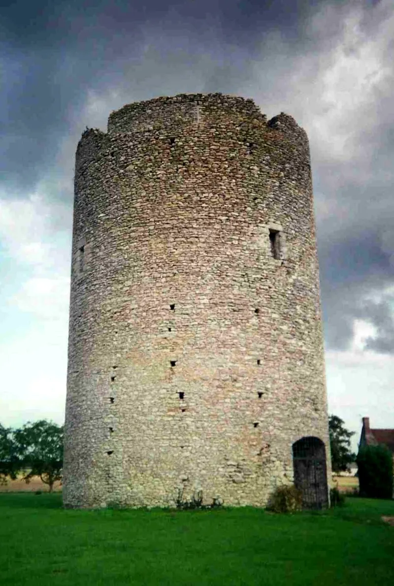
Cette tour cylindrique est le seul vestige important d'une forteresse dont l'origine est inconnue. Elle servit peut-être de poste d'observation fortifié et de lieu de ravitaillement. La muraille est en moellons de meulière noyés dans un mortier très dur. La tour fut partiellement démolie à une époque et dans des circonstances indéterminées. Un aveu de 1583 indique qu'elle fut en partie ruinée par les Anglais. Le chemin de ronde, garni de créneaux et de meurtrières, qui la couronnait, a disparu. Ce qui reste de la tour comportait un rez-de-chaussée et deux étages non voûtés. L'accès devait se faire par des souterrains.
Map and restricted areas
Open in the main mapRestricted zones
Nearby aerodromes
Open aerodromes within 25 km of the spot, heliports included, with their distance and direction from the spot. Near an aerodrome, drone flying is prohibited or height-limited: check the UAS zones map.
| Aerodrome | Type | Distance | Elevation |
|---|---|---|---|
| Amboise Dierre Airport | Aerodrome | 7.5 km NE | 55 m |
| Trousseau Chu Heliport | Heliport | 13 km NW | 84 m |
| Tours Sorigny Airport | Aerodrome | 13 km W | 91 m |
| Tours-Val-de-Loire Airport | Airport | 18 km NW | 109 m |
| Tours Le Louroux Airport | Aerodrome | 20 km SW | 126 m |
Aviation weather (METAR and TAF)
No METAR station within 50 km.
Weather and Kp index
Sunrise and sunset
| Day | Dawn | Sunrise | Golden hour | Sunset | Dusk | Day length |
|---|---|---|---|---|---|---|
| Tue 17 Nov | 07:30 | 08:04 | 08:04–08:52 · 16:32–17:19 | 17:19 | 17:53 | 9 h 15 |
| Wed 18 Nov | 07:32 | 08:05 | 08:05–08:53 · 16:30–17:18 | 17:18 | 17:52 | 9 h 13 |
| Thu 19 Nov | 07:33 | 08:07 | 08:07–08:55 · 16:29–17:17 | 17:17 | 17:51 | 9 h 10 |
| Fri 20 Nov | 07:34 | 08:08 | 08:08–08:56 · 16:28–17:16 | 17:16 | 17:50 | 9 h 08 |
| Sat 21 Nov | 07:36 | 08:09 | 08:09–08:58 · 16:27–17:15 | 17:15 | 17:49 | 9 h 06 |
| Sun 22 Nov | 07:37 | 08:11 | 08:11–09:00 · 16:26–17:15 | 17:15 | 17:48 | 9 h 03 |
| Mon 23 Nov | 07:38 | 08:12 | 08:12–09:01 · 16:25–17:14 | 17:14 | 17:48 | 9 h 01 |
Reviews (0)
Log in to review this spot. Log in · Create a free account
No reviews yet. Share yours!