

Leugny Castle
No reviews yet
Have you flown here? Share your experience with other pilots.
+ Write the first reviewHistory
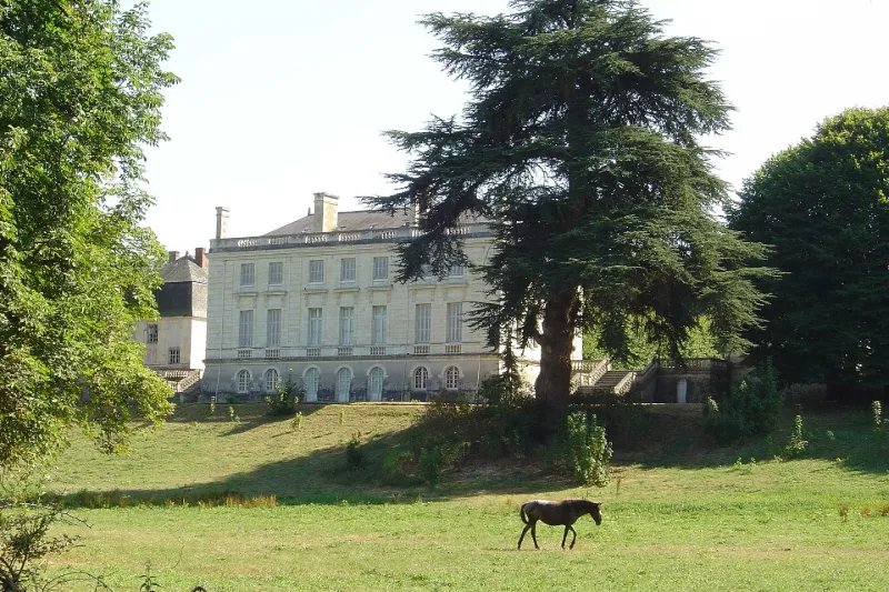
Exemple d'architecture de la fin du 18e siècle, construit par André Portier, architecte et collaborateur de Gabriel. Corps de logis double composé d'un rez-de-chaussée, d'un étage et d'un grenier couronné par une balustrade. Chaque étage est percé de sept fenêtres sur les façades cour et jardin, et quatre à chaque bout du bâtiment. Les portes-fenêtres du rez-de-chaussée sont surmontées d'entablements formant consoles, ornées de fleur de pomme de terre. Situés de part et d'autre de la cour d'honneur, les communs paraissent antérieurs au château.
Map and restricted areas
Open in the main mapRestricted zones
Nearby aerodromes
Open aerodromes within 25 km of the spot, heliports included, with their distance and direction from the spot. Near an aerodrome, drone flying is prohibited or height-limited: check the UAS zones map.
| Aerodrome | Type | Distance | Elevation |
|---|---|---|---|
| Amboise Dierre Airport | Aerodrome | 6.0 km E | 55 m |
| Trousseau Chu Heliport | Heliport | 12 km W | 84 m |
| Tours-Val-de-Loire Airport | Airport | 14 km NW | 109 m |
| Tours Sorigny Airport | Aerodrome | 15 km SW | 91 m |
| Tours Le Louroux Airport | Aerodrome | 25 km SW | 126 m |
Aviation weather (METAR and TAF)
No METAR station within 50 km.
Weather and Kp index
Sunrise and sunset
| Day | Dawn | Sunrise | Golden hour | Sunset | Dusk | Day length |
|---|---|---|---|---|---|---|
| Tue 17 Nov | 07:30 | 08:04 | 08:04–08:52 · 16:31–17:19 | 17:19 | 17:53 | 9 h 15 |
| Wed 18 Nov | 07:32 | 08:05 | 08:05–08:53 · 16:30–17:18 | 17:18 | 17:52 | 9 h 12 |
| Thu 19 Nov | 07:33 | 08:07 | 08:07–08:55 · 16:29–17:17 | 17:17 | 17:51 | 9 h 10 |
| Fri 20 Nov | 07:34 | 08:08 | 08:08–08:57 · 16:28–17:16 | 17:16 | 17:50 | 9 h 08 |
| Sat 21 Nov | 07:36 | 08:10 | 08:10–08:58 · 16:27–17:15 | 17:15 | 17:49 | 9 h 05 |
| Sun 22 Nov | 07:37 | 08:11 | 08:11–09:00 · 16:25–17:14 | 17:14 | 17:48 | 9 h 03 |
| Mon 23 Nov | 07:38 | 08:12 | 08:12–09:01 · 16:24–17:14 | 17:14 | 17:48 | 9 h 01 |
Reviews (0)
Log in to review this spot. Log in · Create a free account
No reviews yet. Share yours!