

Former Abbey and Castle of l'Etoile
No reviews yet
Have you flown here? Share your experience with other pilots.
+ Write the first reviewHistory
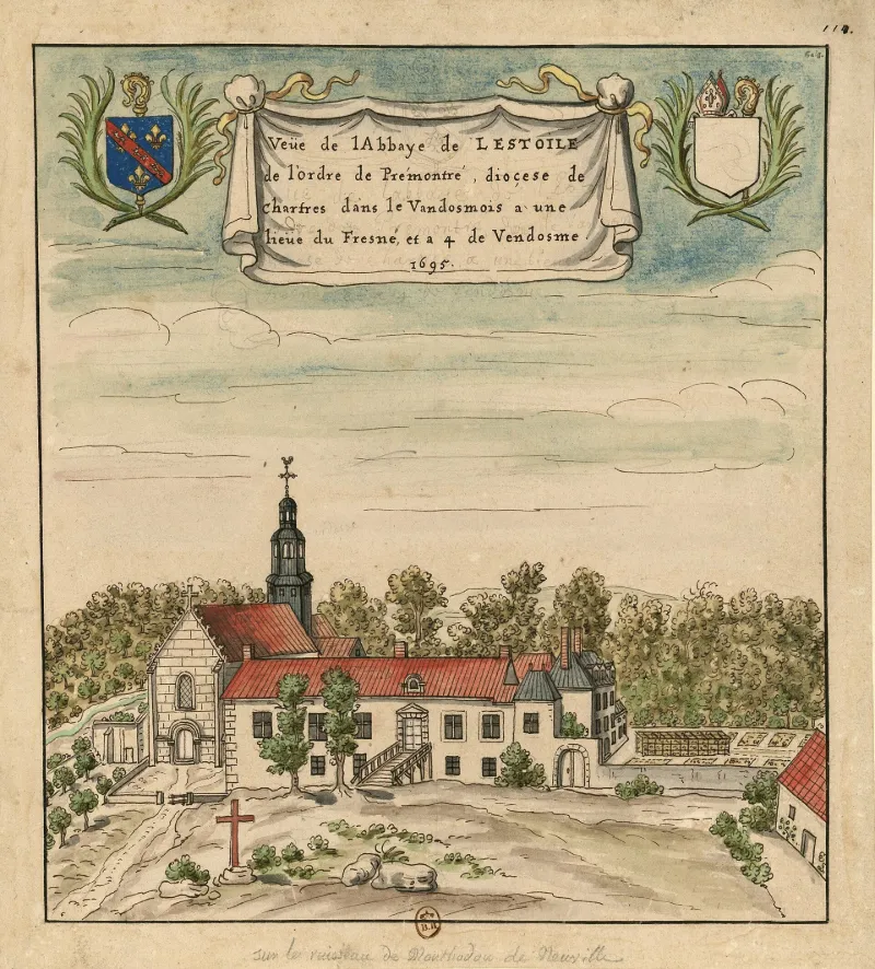
Abbaye fondée dans les années 1130 par le comte de Vendôme, Geoffroy Grisegonelle, et son épouse, Mathilde de Châteaudun. L'abbaye appartient à l'ordre des Prémontrés. En 1559, elle passe en commende. En 1670, elle se réforme. En 1770, elle est réunie à l'abbaye Saint-Georges de Saint-Martin-des-Bois. A partir de 1850, l'ensemble est démantelé par Frédéric de La Rochefoucauld qui fait abattre l'essentiel des bâtiments conventuels et transforme le site pour édifier son château. L'abbatiale comprend une nef de quatre travées et un choeur terminé par une abside cantonnée de deux absidioles. Les deux collatéraux ont été supprimés. Le carré du transept supportait, à l'origine, le clocher central. La façade occidentale conserve son portail d'origine. Le pignon à crochets est une réfection du 16e siècle. L'abbaye se distingue par son caractère dépouillé, refusant toute sculpture décorative. ££Bâti à partir de 1851, le château de l'Etoile est établi sur la partie supérieure ouest du site. Construit d'après les plans de l'architecte Phidias Vestier, il présente un plan massé dans un style éclectique néo-Louis XIII.
Map and restricted areas
Open in the main mapRestricted zones
Nearby aerodromes
Open aerodromes within 25 km of the spot, heliports included, with their distance and direction from the spot. Near an aerodrome, drone flying is prohibited or height-limited: check the UAS zones map.
| Aerodrome | Type | Distance | Elevation |
|---|---|---|---|
| Tours-Val-de-Loire Airport | Airport | 25 km SW | 109 m |
| Aérodrome de Blois-Le Breuil | Aerodrome | 25 km E | 121 m |
Aviation weather (METAR and TAF)
LFOT – Tours-Val-de-Loire Airport VFR
METAR
METAR LFOT 171230Z AUTO 23016KT 9999 ////// 16/// Q0996
- Wind
- 230°, 30 km/h
- Visibility
- 10 km or more
- Clouds
- –
- Temperature
- –
- QNH
- 996 hPa
- Flight category
- VFR: ceiling > 3,000 ft and visibility > 5 mi
TAF
TAF LFOT 171100Z 1712/1812 25020G30KT 9999 BKN025 PROB40 TEMPO 1717/1721 25025G40KT 2500 SHRA BKN020CB PROB30 TEMPO 1718/1721 TS BECMG 1721/1723 24012KT PROB40 TEMPO 1804/1812 24020G30KT PROB30 TEMPO 1804/1810 3000 -TSRA BKN020CB
| Period (local time) | Change | Wind | Visibility | Weather | Clouds |
|---|---|---|---|---|---|
| 17/11 13:00 → 17/11 22:00 | Initial conditions | 250°, 37 km/h, gusts 56 km/h | 10 km or more | Broken (5-7/8) at 2,500 ft (760 m) | |
| 17/11 18:00 → 17/11 22:00 | Temporarily, probability 40% | 250°, 46 km/h, gusts 74 km/h | 2.5 km | Showers of rain | Broken (5-7/8) at 2,000 ft (610 m) (cumulonimbus) |
| 17/11 19:00 → 17/11 22:00 | Temporarily, probability 30% | Thunderstorm | |||
| 17/11 22:00 → 18/11 13:00 | Becoming | 240°, 22 km/h | 10 km or more | Broken (5-7/8) at 2,500 ft (760 m) | |
| 18/11 05:00 → 18/11 13:00 | Temporarily, probability 40% | 240°, 37 km/h, gusts 56 km/h | |||
| 18/11 05:00 → 18/11 11:00 | Temporarily, probability 30% | 3.0 km | Thunderstorm rain light | Broken (5-7/8) at 2,000 ft (610 m) (cumulonimbus) |
Weather and Kp index
| Day | Weather | Temp. min. / max. | Wind | Rain | Max Kp |
|---|---|---|---|---|---|
| Tue 17 Nov | Cloudy | 11° / 15° | 33 km/h SW | 2.6 mm | 5 |
| Wed 18 Nov | Showers | 10° / 14° | 33 km/h SW | 9.0 mm | 5 |
| Thu 19 Nov | Showers | 9° / 13° | 32 km/h SW | 5.3 mm | 3 |
| Fri 20 Nov | Showers | 9° / 13° | 27 km/h SW | 1.4 mm | 3 |
| Sat 21 Nov | Cloudy | 7° / 11° | 21 km/h W | – | – |
| Sun 22 Nov | Rain | 8° / 12° | 26 km/h SW | 13 mm | – |
| Mon 23 Nov | Fair | 6° / 12° | 21 km/h W | 0.2 mm | – |
Hour by hour: Tuesday 17 November
| Time | Weather | Temp. | Wind | Rain | Clouds | Kp |
|---|---|---|---|---|---|---|
| 15:00 | Cloudy | 15° | 31 km/h SW | – | 91 % | 4 |
| 16:00 | Cloudy | 15° | 32 km/h SW | – | 93 % | 4 |
| 17:00 | Light rain | 14° | 32 km/h SW | 0.2 mm | 96 % | 4 |
| 18:00 | Heavy rain | 13° | 31 km/h SW | 1.2 mm | 94 % | 4 |
| 19:00 | Rain | 12° | 29 km/h SW | 0.9 mm | 100 % | 5 |
| 20:00 | Light rain | 12° | 32 km/h SW | 0.3 mm | 100 % | 5 |
| 21:00 | Cloudy | 12° | 33 km/h SW | – | 97 % | 5 |
| 22:00 | Fair | 12° | 29 km/h SW | – | 38 % | 5 |
Hour by hour: Wednesday 18 November
| Time | Weather | Temp. | Wind | Rain | Clouds | Kp |
|---|---|---|---|---|---|---|
| 06:00 | Partly cloudy | 10° | 25 km/h SW | – | 75 % | 4 |
| 07:00 | Partly cloudy | 10° | 25 km/h SW | – | 63 % | 4 |
| 08:00 | Partly cloudy | 10° | 25 km/h SW | – | 68 % | 4 |
| 09:00 | Partly cloudy | 10° | 26 km/h SW | – | 41 % | 4 |
| 10:00 | Fair | 11° | 23 km/h SW | – | 38 % | 4 |
| 11:00 | Fair | 12° | 26 km/h SW | – | 24 % | 4 |
| 12:00 | Showers | 13° | 33 km/h SW | 0.1 mm | 27 % | 4 |
| 13:00 | Showers | 14° | 31 km/h SW | 0.3 mm | 30 % | 3 |
| 14:00 | Fair | 14° | 30 km/h W | – | 29 % | 3 |
| 15:00 | Fair | 14° | 26 km/h SW | – | 26 % | 3 |
| 16:00 | Showers | 13° | 23 km/h SW | 0.2 mm | 18 % | 3 |
| 17:00 | Partly cloudy | 12° | 22 km/h SW | – | 38 % | 3 |
| 18:00 | Cloudy | 11° | 19 km/h SW | – | 96 % | 3 |
| 19:00 | Light rain | 11° | 20 km/h SW | 0.3 mm | 100 % | 2 |
| 20:00 | Heavy rain | 11° | 22 km/h S | 1.3 mm | 100 % | 2 |
| 21:00 | Heavy rain | 11° | 24 km/h S | 1.7 mm | 100 % | 2 |
| 22:00 | Heavy rain | 11° | 24 km/h S | 2.1 mm | 100 % | 2 |
Sunrise and sunset
| Day | Dawn | Sunrise | Golden hour | Sunset | Dusk | Day length |
|---|---|---|---|---|---|---|
| Tue 17 Nov | 07:31 | 08:05 | 08:05–08:53 · 16:30–17:18 | 17:18 | 17:52 | 9 h 13 |
| Wed 18 Nov | 07:32 | 08:06 | 08:06–08:55 · 16:29–17:17 | 17:17 | 17:51 | 9 h 11 |
| Thu 19 Nov | 07:34 | 08:08 | 08:08–08:56 · 16:27–17:16 | 17:16 | 17:50 | 9 h 08 |
| Fri 20 Nov | 07:35 | 08:09 | 08:09–08:58 · 16:26–17:15 | 17:15 | 17:49 | 9 h 06 |
| Sat 21 Nov | 07:36 | 08:10 | 08:10–08:59 · 16:25–17:14 | 17:14 | 17:48 | 9 h 03 |
| Sun 22 Nov | 07:38 | 08:12 | 08:12–09:01 · 16:24–17:13 | 17:13 | 17:48 | 9 h 01 |
| Mon 23 Nov | 07:39 | 08:13 | 08:13–09:03 · 16:23–17:13 | 17:13 | 17:47 | 8 h 59 |
Reviews (0)
Log in to review this spot. Log in · Create a free account
No reviews yet. Share yours!