

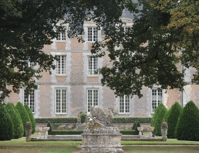
Plessis-Fortia or Plessis-Saint-Amand Castle
No reviews yet
Have you flown here? Share your experience with other pilots.
+ Write the first reviewHistory
Ancien fief relevant du château de Vendôme. Construit en briques et pierres, le château occupe le côté nord-ouest d'une terrasse rectangulaire entourée primitivement de douves sur ses quatre côtés, ces douves ayant été comblées au nord-est sous le Premier Empire. Il se compose d'un bâtiment central et de deux pavillons rectangulaires perpendiculaires et saillant légèrement sur les façades. De part et d'autre du pont de pierre franchissant la douve sud-est pour donner accès à la cour d'honneur, se trouvent deux pavillons en brique et pierre. Au nord-est, le château a été prolongé sous le Premier Empire par un bâtiment d'habitation.
Map and restricted areas
Open in the main mapRestricted zones
| Zone | Category | Limits | Conditions |
|---|---|---|---|
| Zrt Blois | ZRT | FL 050 / FL 110 | SUP AIP 153/26 · Du lundi 20 juillet au jeudi 24 décembre 2026 |
Nearby aerodromes
Open aerodromes within 25 km of the spot, heliports included, with their distance and direction from the spot. Near an aerodrome, drone flying is prohibited or height-limited: check the UAS zones map.
| Aerodrome | Type | Distance | Elevation |
|---|---|---|---|
| Aérodrome de Blois-Le Breuil | Aerodrome | 16 km E | 121 m |
Aviation weather (METAR and TAF)
No METAR station within 50 km.
Weather and Kp index
Sunrise and sunset
| Day | Dawn | Sunrise | Golden hour | Sunset | Dusk | Day length |
|---|---|---|---|---|---|---|
| Tue 17 Nov | 07:31 | 08:04 | 08:04–08:53 · 16:29–17:17 | 17:17 | 17:51 | 9 h 13 |
| Wed 18 Nov | 07:32 | 08:06 | 08:06–08:54 · 16:28–17:16 | 17:16 | 17:50 | 9 h 10 |
| Thu 19 Nov | 07:33 | 08:07 | 08:07–08:56 · 16:27–17:15 | 17:15 | 17:49 | 9 h 08 |
| Fri 20 Nov | 07:35 | 08:09 | 08:09–08:58 · 16:25–17:14 | 17:14 | 17:48 | 9 h 05 |
| Sat 21 Nov | 07:36 | 08:10 | 08:10–08:59 · 16:24–17:13 | 17:13 | 17:48 | 9 h 03 |
| Sun 22 Nov | 07:37 | 08:12 | 08:12–09:01 · 16:23–17:13 | 17:13 | 17:47 | 9 h 01 |
| Mon 23 Nov | 07:39 | 08:13 | 08:13–09:03 · 16:22–17:12 | 17:12 | 17:46 | 8 h 58 |

Reviews (0)
Log in to review this spot. Log in · Create a free account
No reviews yet. Share yours!